File:Sfc map 20230405.png
Aller à la navigation
Aller à la recherche

Taille de cet aperçu : 800 × 576 pixels. Autres résolutions : 320 × 230 pixels | 640 × 461 pixels | 1 024 × 737 pixels | 1 088 × 783 pixels.
Fichier d’origine (1 088 × 783 pixels, taille du fichier : 147 kio, type MIME : image/png)
Légendes
Légendes
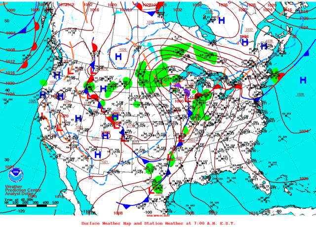
Carte météorologique de l'Amérique du Nord le 5 avril 2023 à 12 UTC
Description
[modifier]
| Description |
Français : Carte météorologique de l'Amérique du Nord le 5 avril 2023 à 12 UTC. Les front sont indiqué selon les convention et la température de 0 degrés Celsius est en tiretés bleus.
English: North American weather map of 12 UTC on April 5, 2023. The fronts are shown according to conventions and the freezing temperature is the dash blue line. |
| Date | |
| Source | https://www.wpc.ncep.noaa.gov/dailywxmap/dwm_stnplot_20230405.html |
| Auteur | Weather Prediction Centre of the National Weather Service |
Conditions d’utilisation
[modifier]
This image is in the public domain because it was stored on the web servers of the U.S. National Weather Service. NWS-created images are automatically public domain in the U.S. since the NWS is a part of the U.S. government. However, the NWS sites also host non-NWS images which have been submitted by individuals: these are generally shown as "Courtesy of ...". Such images have explicitly been released to the public domain by the copyright owner as part of the upload process.
As stated at https://www.weather.gov/fsd/disclaimer: "By submitting images, you understand that your image is being released into the public domain. This means that your photo or video may be downloaded, copied, and used by others." Thus, all* images on NWS servers are public domain (including "Courtesy of ..." and “Photo by ...” images) unless specifically stated otherwise through a copyright (©) watermark.
*A deletion discussion in November 2023 ruled that Getty Images on the web servers of NWS, are to be considered copyrighted, even without a copyright (©) watermark and are the sole exception to this rule.
|
Historique du fichier
Cliquer sur une date et heure pour voir le fichier tel qu'il était à ce moment-là.
| Date et heure | Vignette | Dimensions | Utilisateur | Commentaire | |
|---|---|---|---|---|---|
| actuel | 19 avril 2023 à 03:29 | | 1 088 × 783 (147 kio) | Pierre cb (d | contributions) | Uploaded a work by {{w|Weather Prediction Centre}} of the {{w|National Weather Service}} from https://www.wpc.ncep.noaa.gov/dailywxmap/dwm_stnplot_20230405.html with UploadWizard |
Vous ne pouvez pas remplacer ce fichier.
Utilisations locales du fichier
Aucune page n’utilise ce fichier.
Utilisations du fichier sur d’autres wikis
Les autres wikis suivants utilisent ce fichier :
- Utilisation sur en.wikipedia.org
- Utilisation sur fr.wikipedia.org