File:Situatiekaart van Schokland 1788.jpg
Jump to navigation
Jump to search
Size of this preview: 800 × 256 pixels. Other resolutions: 320 × 102 pixels | 1,000 × 320 pixels.
Original file (1,000 × 320 pixels, file size: 42 KB, MIME type: image/jpeg)
Captions
Captions
Add a one-line explanation of what this file represents
Summary[edit]
| Description |
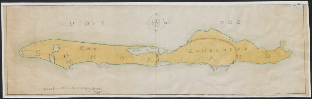
Nederlands: Situatiekaarten van Schokland, met daarop aangegeven de te verbeteren zeeweringen. 3 bladen, waarvan nr. 14659 een deel van het eiland weergeeft. Vgl. Landdagstukken, februari 1789, punt 69 en resolutie van de staten van Friesland van 27-2-1792. |
| Date | |
| Source | http://www.frieskaartenkabinet.nl/nl/fries-kaartenkabinet/14657 |
| Author | Unknown author |
Licensing[edit]
|
This work is in the public domain in its country of origin and other countries and areas where the copyright term is the author's life plus 100 years or fewer. This work is in the public domain in the United States because it was published (or registered with the U.S. Copyright Office) before January 1, 1929. | |
| This file has been identified as being free of known restrictions under copyright law, including all related and neighboring rights. | |
File history
Click on a date/time to view the file as it appeared at that time.
| Date/Time | Thumbnail | Dimensions | User | Comment | |
|---|---|---|---|---|---|
| current | 20:13, 10 September 2015 | 1,000 × 320 (42 KB) | Hannolans (talk | contribs) | User created page with UploadWizard |
You cannot overwrite this file.
File usage on Commons
There are no pages that use this file.
File usage on other wikis
The following other wikis use this file:
- Usage on de.wikipedia.org
- Usage on nl.wikipedia.org