File:Sketch of rebel fortifications at Hayne's Bluff. LOC 99447416.jpg
Jump to navigation
Jump to search

Size of this preview: 800 × 265 pixels. Other resolutions: 320 × 106 pixels | 640 × 212 pixels | 1,024 × 339 pixels | 1,280 × 424 pixels | 2,560 × 847 pixels | 8,473 × 2,805 pixels.
Original file (8,473 × 2,805 pixels, file size: 2.92 MB, MIME type: image/jpeg)
Captions
Captions
Add a one-line explanation of what this file represents
Summary
[edit]| Description |
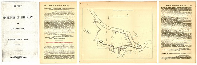
English: Scale ca. 1:23,000. LC Civil War Maps (2nd ed.), 271.5 From Report of the Secretary of the Navy, with an appendix, containing reports from officers. December 1863, (Washington, Government Printing Office, 1863). opp. p. 492. Map accompanies Acting Rear Adm. David D. Porter's report dated May 20, 1863, entitled "Destruction of the fortifications at Haines's Bluff." Description derived from published bibliography. Available also through the Library of Congress web site as raster image. |
||
| Title | Sketch of rebel fortifications at Hayne's Bluff. | ||
| Shelf ID | G3984.H39 1863 .U5 | ||
| Date | |||
| Source | https://www.loc.gov/item/99447416/ | ||
| Author | United States. Navy | ||
| Permission (Reusing this file) |
|
||
| Other versions |
|
||
| Location | United States · Mississippi · Haynes Bluff Landing | ||
| Part of | Military Battles And Campaigns · American Memory · Civil War Maps · Catalog · Geography And Map Division | ||
| Subject | United States · Maps · Mississippi · Haynes Bluff Landing (Miss.) · Haynes Bluff Landing |

.jpg)
Licensing
[edit]
|
This is a faithful photographic reproduction of a two-dimensional, public domain work of art. The work of art itself is in the public domain for the following reason:
The official position taken by the Wikimedia Foundation is that "faithful reproductions of two-dimensional public domain works of art are public domain".
This photographic reproduction is therefore also considered to be in the public domain in the United States. In other jurisdictions, re-use of this content may be restricted; see Reuse of PD-Art photographs for details. | ||||
File history
Click on a date/time to view the file as it appeared at that time.
| Date/Time | Thumbnail | Dimensions | User | Comment | |
|---|---|---|---|---|---|
| current | 19:09, 16 May 2018 | 8,473 × 2,805 (2.92 MB) | Fæ (talk | contribs) | LOC Maps https://www.loc.gov/item/99447416/ #9634 |
You cannot overwrite this file.
File usage on Commons
The following 2 pages use this file: