File:Smith River Hotshots (31038634805).jpg
Original file (6,936 × 3,902 pixels, file size: 26.66 MB, MIME type: image/jpeg)
Captions
Summary
[edit]DescriptionSmith River Hotshots (31038634805).jpg |
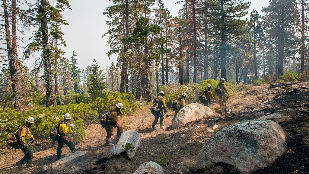
The Smith River Hotshots work in a tree mortality area at the Cedar Fire which took place on the Sequoia National Forest. Photo by Lance Cheung, USDA, Tuesday, August 23, 2016. |
Date | |
Source | Smith River Hotshots |
Author | Pacific Southwest Region 5 |
Camera location | 35° 45′ 02.04″ N, 118° 31′ 26.35″ W | View this and other nearby images on: OpenStreetMap | 35.750567; -118.523987 |
---|
Licensing
[edit]- You are free:
- to share – to copy, distribute and transmit the work
- to remix – to adapt the work
- Under the following conditions:
- attribution – You must give appropriate credit, provide a link to the license, and indicate if changes were made. You may do so in any reasonable manner, but not in any way that suggests the licensor endorses you or your use.
This image was originally posted to Flickr by Forest Service, USDA at https://flickr.com/photos/39108150@N05/31038634805. It was reviewed on 8 May 2018 by FlickreviewR 2 and was confirmed to be licensed under the terms of the cc-by-2.0. |
8 May 2018
Public domainPublic domainfalsefalse |
This image or file is a work of a United States Department of Agriculture employee, taken or made as part of that person's official duties. As a work of the U.S. federal government, the image is in the public domain.
English ∙ español ∙ Nederlands ∙ slovenščina ∙ Tiếng Việt ∙ македонски ∙ русский ∙ українська ∙ 日本語 ∙ +/− |
File history
Click on a date/time to view the file as it appeared at that time.
Date/Time | Thumbnail | Dimensions | User | Comment | |
---|---|---|---|---|---|
current | 20:18, 8 May 2018 | 6,936 × 3,902 (26.66 MB) | OceanAtoll (talk | contribs) | Transferred from Flickr via #flickr2commons |
You cannot overwrite this file.
File usage on Commons
There are no pages that use this file.
Metadata
This file contains additional information such as Exif metadata which may have been added by the digital camera, scanner, or software program used to create or digitize it. If the file has been modified from its original state, some details such as the timestamp may not fully reflect those of the original file. The timestamp is only as accurate as the clock in the camera, and it may be completely wrong.
Image title |
|
---|---|
Camera manufacturer | NIKON CORPORATION |
Camera model | NIKON D800 |
Author | Lance Cheung |
Copyright holder |
|
Exposure time | 1/500 sec (0.002) |
F-number | f/14 |
ISO speed rating | 640 |
Date and time of data generation | 09:36, 23 August 2016 |
Lens focal length | 17 mm |
User comments | USDA Photo by Lance Cheung. |
Latitude | 35° 45′ 2.04″ N |
Longitude | 118° 31′ 26.35″ W |
Altitude | 2,066 meters above sea level |
Label | Approved |
Usage terms |
|
Short title |
|
Software used | Adobe Bridge CS6 (Macintosh) |
File change date and time | 11:56, 30 August 2016 |
Exposure Program | Normal program |
Exif version | 2.21 |
Date and time of digitizing | 09:36, 23 August 2016 |
APEX shutter speed | 8.965784 |
APEX aperture | 7.61471 |
APEX exposure bias | −0.66666666666667 |
Maximum land aperture | 3 APEX (f/2.83) |
Metering mode | Center weighted average |
Light source | Fine weather |
Flash | Flash did not fire, compulsory flash suppression |
DateTimeOriginal subseconds | 00 |
DateTimeDigitized subseconds | 00 |
Focal plane X resolution | 2,048.4022216797 |
Focal plane Y resolution | 2,048.4022216797 |
Focal plane resolution unit | 3 |
Sensing method | One-chip color area sensor |
File source | Digital still camera |
Scene type | A directly photographed image |
Exposure mode | Auto exposure |
White balance | Manual white balance |
Digital zoom ratio | 1 |
Focal length in 35 mm film | 17 mm |
Scene capture type | Standard |
Scene control | Low gain up |
Contrast | Normal |
Saturation | Normal |
Sharpness | Normal |
Subject distance range | Unknown |
GPS time (atomic clock) | 17:36 |
Satellites used for measurement | 07 |
Geodetic survey data used | WGS 84 |
GPS date | 23 August 2016 |
GPS tag version | 2.3.0.0 |
Serial number of camera | 3078763 |
Lens used | 17.0-35.0 mm f/2.8 |
Date metadata was last modified | 04:56, 30 August 2016 |
Rating (out of 5) | 5 |
Unique ID of original document | 365968579D597AAE0AC1729D71E75586 |
Copyright status | Copyright status not set |
Contact information | lance.cheung@oc.usda.gov
www.flickr.com/photos/usdagov 1400 Independence Avenue, SW Washington, District of Columbia, 202150 USA |
Keywords | USDA “Department of Agriculture” forest “national forest” wildfire wildland “forest fire” “U.S. Forest Service” Kernville “Lake Isabella” “Kern River” “Tulare County” “Kern County” Posey Ponderosa “tree morality” pine Sequoia Redwood firefighter. |
IIM version | 4 |