File:Snow Across the Himalayas and Kunlun Mountains (MODIS).jpg
Jump to navigation
Jump to search

Size of this preview: 782 × 600 pixels. Other resolutions: 313 × 240 pixels | 626 × 480 pixels | 1,002 × 768 pixels | 1,280 × 982 pixels | 2,560 × 1,963 pixels | 6,098 × 4,676 pixels.
Original file (6,098 × 4,676 pixels, file size: 4.37 MB, MIME type: image/jpeg)
Captions
Captions
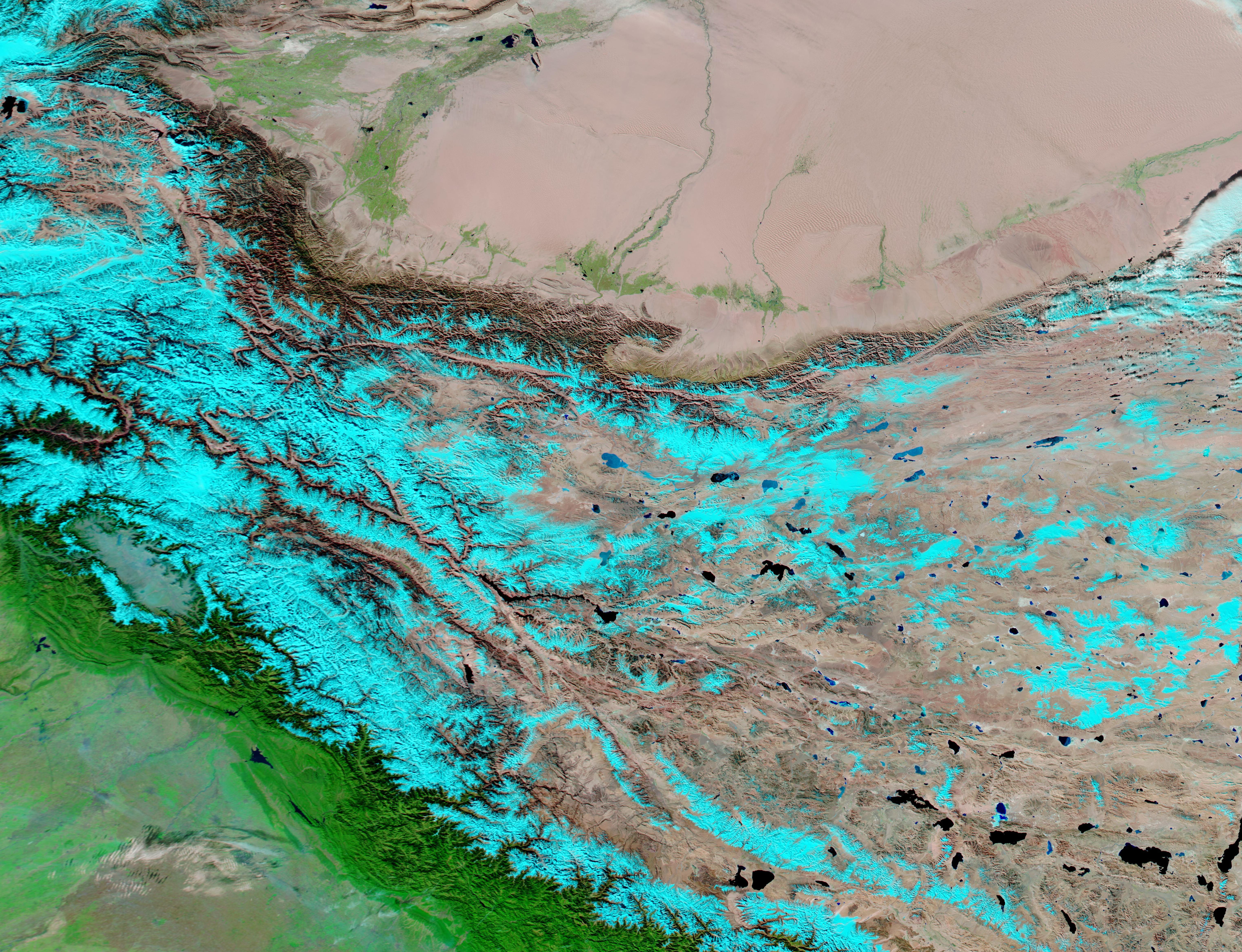
On November 24, the Moderate Resolution Imaging Spectroradiometer (MODIS) on board NASA’s Aqua satellite acquired a false-color image of the tall peaks between China’s Taklamakan Desert (north) and India’s Indo-Gangetic Plain.
Summary
[edit].jpg&action=edit§ion=1)
| Description |
English: Fresh snow topped the Himalayas and the Kunlun Mountains in late November 2022.
On November 24, the Moderate Resolution Imaging Spectroradiometer (MODIS) on board NASA’s Aqua satellite acquired a false-color image of the tall peaks between China’s Taklamakan Desert (north) and India’s Indo-Gangetic Plain. The use of infrared and visible light (MODIS bands 7,2,1) helps separate snow, which appears bright electric blue, from standing water/lakes, which appear dark blue. Also, vegetation appears bright green while open land looks tan or brown. The extremely dry and sand-filled Taklamakan Desert fills the northern section of the image. Vegetation flourishes where moisture exists, both around the edges of the desert and along a very few rivers that flow toward the center of the Taklamakan. The topography sharply increases on the southwestern and southern edge of the desert, where the Kunlun Mountains rise upward more than 23,000 feet in some locations. Further south, the tall Himalaya Mountains roughly parallel the Kunlun in the west, but the two ranges diverge in the east, split by the Tibetan Plateau. The Tibetan Plateau is sometimes called the “Roof of the World” as it is the world’s highest and largest plateau, with an average elevation of more than 14,000 feet. Many lakes speckle the Tibetan Plateau. The southern slopes of the Himalayas are covered with deep green vegetation, indicating abundant moisture. The low-lying plain at the foot of the Himalayas is an extremely fertile region, as can be inferred from the abundant vegetation that spreads southward to the edge of the image. |
||
| Date | Taken on 24 November 2022 | ||
| Source |
Snow Across the Himalayas and Kunlun Mountains (direct link)
|
||
| Author | MODIS Land Rapid Response Team, NASA GSFC |
| This media is a product of the Aqua mission Credit and attribution belongs to the mission team, if not already specified in the "author" row |
Licensing
[edit].jpg&action=edit§ion=2)
| This file is in the public domain in the United States because it was solely created by NASA. NASA copyright policy states that "NASA material is not protected by copyright unless noted". (See Template:PD-USGov, NASA copyright policy page or JPL Image Use Policy.) | ||
 |
Warnings:
|
File history
Click on a date/time to view the file as it appeared at that time.
| Date/Time | Thumbnail | Dimensions | User | Comment | |
|---|---|---|---|---|---|
| current | 10:05, 30 August 2023 | | 6,098 × 4,676 (4.37 MB) | OptimusPrimeBot (talk | contribs) | #Spacemedia - Upload of http://modis.gsfc.nasa.gov/gallery/images/image11262022_250m.jpg via Commons:Spacemedia |
You cannot overwrite this file.
File usage on Commons
There are no pages that use this file.
.jpg&oldid=909385035)