File:Snow around the Grand Canyon (MODIS 2018-12-08).jpg

Original file (1,873 × 1,466 pixels, file size: 449 KB, MIME type: image/jpeg)
Captions
Captions
Summary
[edit].jpg&action=edit§ion=1)
| Description |
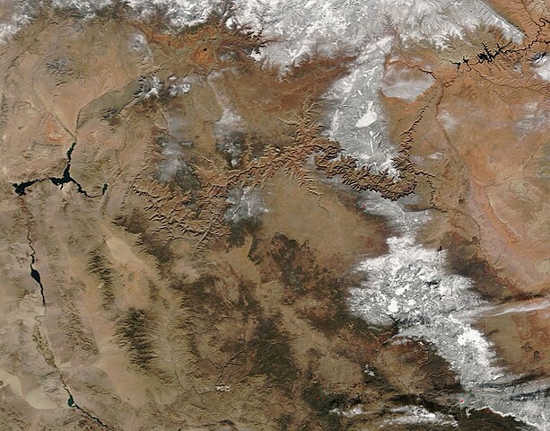
English: A far-reaching winter storm brought heavy snow to Arizona in late November, 2018 before sweeping northeastward to bring ice and snow to a wide swath of states, including Maine, before moving offshore. The Weather Center reported that 10 inches (25.4 cm) of fresh snow fell on the North Rim of the Grand Canyon on November 30, while Flagstaff acquired 5.8 in (14.7 cm). Light snow continued through much of Arizona through December 2.
On December 3, 2018, the Moderate Resolution Imaging Spectroradiometer (MODIS) on board NASA’s Terra satellite acquired a true-color image centered on the Grand Canyon after the passing of the storm. The rugged terrain of the Grand Canyon, carved primarily by the Colorado River over the past six millions years, is one of North America’s most spectacular geological features. Spanning about 277 miles (466 km) of the Arizona Desert, the canyon drops as much as 5,000 feet (1,524 meters) to reach the winding Colorado River. The North Rim is the highest elevation in Grand Canyon National Park, reaching over 8,000 feet (2,438 m). According to the National Park Service, winter precipitation usually falls as snow on the rims, but melts to rain before reaching the canyon floor. The North Rim receives the heaviest snowfall, averaging 142” per year, with a record snowfall of 272.8” (almost 23 feet) in 1978. The South Rim averages 58” of snow, and Phantom Ranch less than 1”. |
||
| Date | Taken on 3 December 2018 | ||
| Source |
Snow around the Grand Canyon (direct link)
|
||
| Author | MODIS Land Rapid Response Team, NASA GSFC |
| This media is a product of the Terra mission Credit and attribution belongs to the mission team, if not already specified in the "author" row |
Licensing
[edit].jpg&action=edit§ion=2)
| This file is in the public domain in the United States because it was solely created by NASA. NASA copyright policy states that "NASA material is not protected by copyright unless noted". (See Template:PD-USGov, NASA copyright policy page or JPL Image Use Policy.) | ||
 |
Warnings:
|
File history
Click on a date/time to view the file as it appeared at that time.
| Date/Time | Thumbnail | Dimensions | User | Comment | |
|---|---|---|---|---|---|
| current | 01:20, 17 February 2024 | | 1,873 × 1,466 (449 KB) | OptimusPrimeBot (talk | contribs) | #Spacemedia - Upload of http://modis.gsfc.nasa.gov/gallery/images/image12082018_250m.jpg via Commons:Spacemedia |
You cannot overwrite this file.
File usage on Commons
There are no pages that use this file.
.jpg&oldid=852926957)