File:Socsksargen.png
Jump to navigation
Jump to search

Size of this preview: 507 × 600 pixels. Other resolutions: 203 × 240 pixels | 406 × 480 pixels | 649 × 768 pixels | 866 × 1,024 pixels | 1,846 × 2,183 pixels.
Original file (1,846 × 2,183 pixels, file size: 475 KB, MIME type: image/png)
Captions
Captions
Add a one-line explanation of what this file represents
Summary[edit]
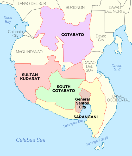
| Description | Political Map of Socsksargen Region, Philippines. Showing Cotabato, Sarangani, South Cotabato, Sultan Kudarat and General Santos City. Used:PhlMapCit.svg by Felipe_Aira and Philippines location map.svg by NordNordWest |
| Date | |
| Source | Own work |
| Author | Exec8 |
This file is licensed under the Creative Commons Attribution-Share Alike 4.0 International license.
- You are free:
- to share – to copy, distribute and transmit the work
- to remix – to adapt the work
- Under the following conditions:
- attribution – You must give appropriate credit, provide a link to the license, and indicate if changes were made. You may do so in any reasonable manner, but not in any way that suggests the licensor endorses you or your use.
- share alike – If you remix, transform, or build upon the material, you must distribute your contributions under the same or compatible license as the original.
File history
Click on a date/time to view the file as it appeared at that time.
| Date/Time | Thumbnail | Dimensions | User | Comment | |
|---|---|---|---|---|---|
| current | 19:15, 28 November 2021 | | 1,846 × 2,183 (475 KB) | Magog the Ogre (talk | contribs) | Reverted to version as of 03:41, 28 November 2021 (UTC) |
| 03:41, 28 November 2021 | No thumbnail | 865 × 1,197 (151 KB) | Sanchezph (talk | contribs) | Reverted to version as of 03:37, 28 November 2021 (UTC) | |
| 03:41, 28 November 2021 |  | 1,846 × 2,183 (475 KB) | Sanchezph (talk | contribs) | Reverted to version as of 08:56, 30 March 2021 (UTC) | |
| 03:37, 28 November 2021 | No thumbnail | 865 × 1,197 (151 KB) | Sanchezph (talk | contribs) | Reverted to version as of 12:17, 28 March 2021 (UTC) | |
| 08:56, 30 March 2021 |  | 1,846 × 2,183 (475 KB) | HueMan1 (talk | contribs) | Reverted to version as of 15:32, 14 May 2020 (UTC) | |
| 12:17, 28 March 2021 | No thumbnail | 865 × 1,197 (151 KB) | Teamayuiyui (talk | contribs) | 4 Provinces | |
| 15:32, 14 May 2020 |  | 1,846 × 2,183 (475 KB) | HueMan1 (talk | contribs) | Reverted to version as of 01:23, 30 January 2019 (UTC) | |
| 01:23, 30 January 2019 |  | 1,846 × 2,183 (475 KB) | Exec8 (talk | contribs) | Border adjustments | |
| 05:20, 29 January 2019 |  | 1,829 × 2,180 (382 KB) | Exec8 (talk | contribs) | == {{int:filedesc}} == {{Information |description=Political Map of Socsksargen Region, Philippines. Showing Cotabato, Sarangani, South Cotabato, Sultan Kudarat and General Santos City. Used:PhlMapCit.svg by Felipe_Aira and Philippines location map.svg by [[User:No... |
You cannot overwrite this file.
File usage on Commons
There are no pages that use this file.
File usage on other wikis
The following other wikis use this file:
- Usage on bcl.wikipedia.org
- Usage on ceb.wikipedia.org
- Usage on en.wikipedia.org
- Usage on es.wikipedia.org
- Usage on hi.wikipedia.org
- Usage on incubator.wikimedia.org
- Usage on ka.wikipedia.org
- გენერალ-სანტოსი
- კოტაბატოს პროვინცია
- სამხრეთი კოტაბატო
- თარგი:საკოკსკსარგენი
- ბანგა (სამხრეთი კოტაბატო)
- ლაკე-სებუ (სამხრეთი კოტაბატო)
- ნორალა
- პოლომოლოკი
- სანტო-ნინიო (სამხრეთი კოტაბატო)
- სურალია
- ტამპაკანი
- ტუპი (სამხრეთი კოტაბატო)
- ტანტანგანი
- ტ'ბოლი (სამხრეთი კოტაბატო)
- ალამადა
- ალეოსანი
- ანტიპასი (კოტაბატო)
- არაკანი (კოტაბატო)
- ბანისილანი
- კარმენი (კოტაბატო)
- კაბაკანი
- ლიბუნგანი
- მაგპეტი
- მაკილალა
- მატალამი
- პიგკავაიანი
- მ'ლანგი
- მიდსაიაპი
- პიკიტი
- პრესიდენტ-როხასი (კოტაბატო)
- ტულუნანი
View more global usage of this file.