File:Sogn og Fjordane Municipalities.png
Jump to navigation
Jump to search
Size of this preview: 800 × 487 pixels. Other resolutions: 320 × 195 pixels | 640 × 390 pixels | 1,025 × 624 pixels.
Original file (1,025 × 624 pixels, file size: 29 KB, MIME type: image/png)
Captions
Captions
Add a one-line explanation of what this file represents

|
This locator map image could be re-created using vector graphics as an SVG file. This has several advantages; see Commons:Media for cleanup for more information. If an SVG form of this image is available, please upload it and afterwards replace this template with
{{vector version available|new image name}}.
It is recommended to name the SVG file “Sogn og Fjordane Municipalities.svg”—then the template Vector version available (or Vva) does not need the new image name parameter. |
Transferred from en.wikipedia to Commons by Maksim.
The original description page was here. All following user names refer to en.wikipedia.
Summary[edit]
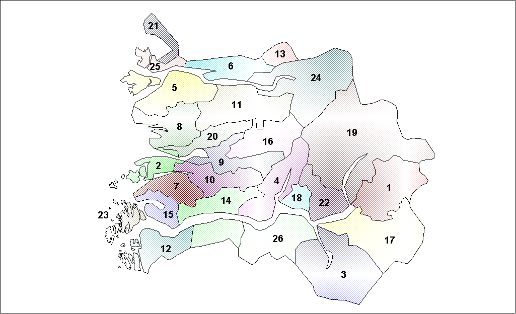
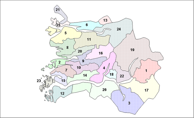
Map of the municipalities of Sogn og Fjordane County in Norway. Created by Rarelibra for public domain use. Created using MapInfo Professional v7.5 and various mapping resources.
Licensing[edit]
| I, the copyright holder of this work, release this work into the public domain. This applies worldwide. In some countries this may not be legally possible; if so: I grant anyone the right to use this work for any purpose, without any conditions, unless such conditions are required by law. |
| date/time | username | edit summary |
|---|---|---|
| 14:58, 26 January 2006 | en:User:Rarelibra | (Map of the municipalities of Sogn og Fjordane County in Norway. Created by <a href="/wiki/User:Rarelibra" title="User:Rarelibra">Rarelibra</a> for public domain use. Created using MapInfo Professional v7.5 and various mapping resources.) |
Original upload log[edit]
Legend: (cur) = this is the current file, (del) = delete this old version, (rev) = revert to this old version.
Click on date to download the file or see the image uploaded on that date.
- (del) (cur) 18:36, 26 January 2006 . . en:User:Rarelibra Rarelibra ( en:User_talk:Rarelibra Talk) . . 1025x624 (30045 bytes) (Map of the municipalities of Sogn og Fjordane County in Norway. Created by en:User:Rarelibra Rarelibra for public domain use. Created using MapInfo Professional v7.5 and various mapping resources.)
- (del) (rev) 14:58, 26 January 2006 . . en:User:Rarelibra Rarelibra ( en:User_talk:Rarelibra Talk) . . 1025x624 (30510 bytes) (Map of the municipalities of Sogn og Fjordane County in Norway. Created by en:User:Rarelibra Rarelibra for public domain use. Created using MapInfo Professional v7.5 and various mapping resources.)
File history
Click on a date/time to view the file as it appeared at that time.
| Date/Time | Thumbnail | Dimensions | User | Comment | |
|---|---|---|---|---|---|
| current | 08:57, 26 March 2006 | | 1,025 × 624 (29 KB) | Maksim (talk | contribs) | La bildo estas kopiita de wikipedia:en. La originala priskribo estas: == Summary == Map of the municipalities of Sogn og Fjordane County in Norway. Created by Rarelibra for public domain use. Created using MapInfo Professional v7.5 and |
You cannot overwrite this file.
File usage on Commons
There are no pages that use this file.
File usage on other wikis
The following other wikis use this file:
- Usage on bat-smg.wikipedia.org
- Usage on en.wikipedia.org
- Usage on eo.wikipedia.org
- Usage on es.wikipedia.org
- Usage on et.wikipedia.org
- Usage on eu.wikipedia.org
- Usage on hr.wikipedia.org
- Usage on hu.wikipedia.org
- Usage on id.wikipedia.org
- Usage on ja.wikipedia.org
- Usage on ka.wikipedia.org
- Usage on ko.wikipedia.org
- Usage on lt.wikipedia.org
- Usage on nl.wikipedia.org
- Usage on pt.wikipedia.org
- Usage on ru.wikipedia.org
- Usage on sr.wikipedia.org
- Usage on sw.wikipedia.org
- Usage on uk.wikipedia.org
- Usage on vi.wikipedia.org
- Usage on zea.wikipedia.org
- Usage on zh.wikipedia.org