File:Soil Map of Door County, Wisconsin 1910.tif
Jump to navigation
Jump to search

Size of this JPG preview of this TIF file: 399 × 599 pixels. Other resolutions: 160 × 240 pixels | 319 × 480 pixels | 511 × 768 pixels | 682 × 1,024 pixels | 1,413 × 2,122 pixels.
Original file (1,413 × 2,122 pixels, file size: 4.76 MB, MIME type: image/tiff)
Captions
Captions
Add a one-line explanation of what this file represents
Summary
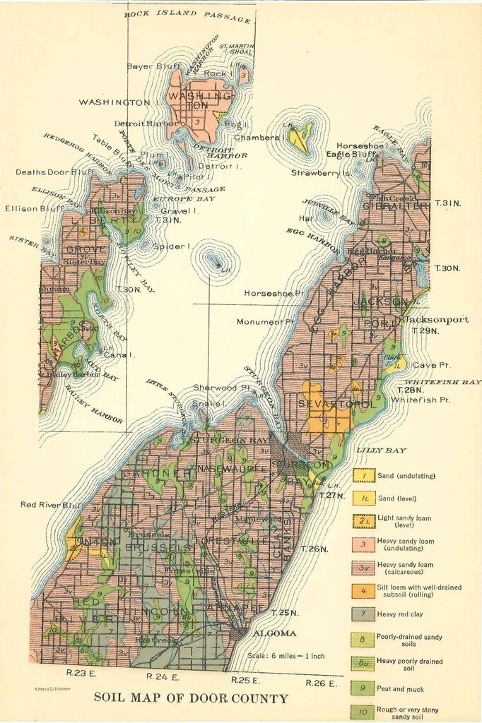
[edit]| Description | Soil Map of Door County, Wisconsin; Scale: 6.5 x 9.5 in, scale: 6 miles = 1 inch | ||
| Date | |||
| Source | https://wgnhs.wisc.edu/catalog/publication/000924/resource/m149dr ; Soil Maps of Northern Wisconsin Counties, Wisconsin Geological and Natural History Survey Series # M149-DR | ||
| Author | Wisconsin Geological and Natural History Survey | ||
| Permission (Reusing this file) |
|
File history
Click on a date/time to view the file as it appeared at that time.
| Date/Time | Thumbnail | Dimensions | User | Comment | |
|---|---|---|---|---|---|
| current | 03:43, 5 December 2021 |  | 1,413 × 2,122 (4.76 MB) | Epiphyllumlover (talk | contribs) | Transferred from https://downloads2.sejda.com/api/tasks/WO233W51-202112050438/download/M149-DR-1.tif?s=web-S6UMjUDuqwpJMBBHgkkzOaWNw7lUdlW2uduao&d=true&_s=16 |
You cannot overwrite this file.
File usage on Commons
There are no pages that use this file.
File usage on other wikis
The following other wikis use this file:
- Usage on en.wikipedia.org