File:Sonderbereichmürwik.png
Jump to navigation
Jump to search

Size of this preview: 597 × 600 pixels. Other resolutions: 239 × 240 pixels | 478 × 480 pixels | 764 × 768 pixels | 1,019 × 1,024 pixels | 1,496 × 1,503 pixels.
Original file (1,496 × 1,503 pixels, file size: 836 KB, MIME type: image/png)
Captions
Captions
Add a one-line explanation of what this file represents

|
This map image could be re-created using vector graphics as an SVG file. This has several advantages; see Commons:Media for cleanup for more information. If an SVG form of this image is available, please upload it and afterwards replace this template with
{{vector version available|new image name}}.
It is recommended to name the SVG file “Sonderbereichmürwik.svg”—then the template Vector version available (or Vva) does not need the new image name parameter. |
Summary
[edit]
| Description |
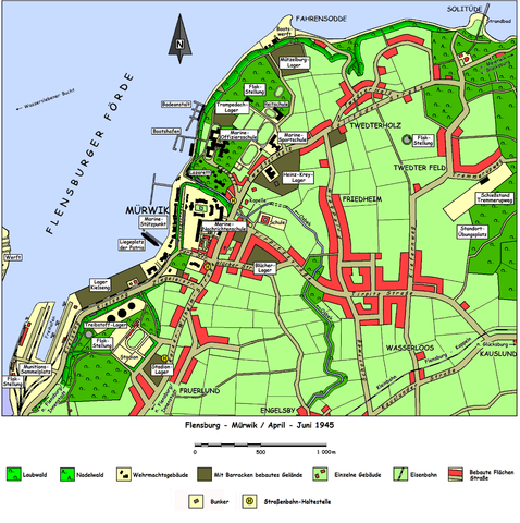
Deutsch: Karte des Flensburger Stadtteils Mürwik in der Situation des Frühjahrs 1945. Es sind alle für die geschichtlichen Ereignisse relevanten Plätze und Orte eingezeichnet. |
| Source |
Own work Die Karte wurde unter Übernahme von Messpunkten aus älteren Karten und Luftbildern selbst gezeichnet. |
| Author | de:Benutzer:HEROMAX |
(Original text: selbst erstellt)
Licensing
[edit]

|
Permission is granted to copy, distribute and/or modify this document under the terms of the GNU Free Documentation License, Version 1.2 or any later version published by the Free Software Foundation; with no Invariant Sections, no Front-Cover Texts, and no Back-Cover Texts. A copy of the license is included in the section entitled GNU Free Documentation License. |
| This file is licensed under the Creative Commons Attribution-Share Alike 3.0 Unported license. | ||
| ||
| This licensing tag was added to this file as part of the GFDL licensing update. |
Original upload log
[edit]
Transferred from de.wikipedia to Commons by Wdwdbot using script bot_filetrans.pl.
The original description page was here. All following user names refer to de.wikipedia.
- 2005-09-18 16:59:25 HEROMAX (856072 Bytes) Karte des Flensburger Stadtteils Mürwik in der Situation des Frühjahrs 1945. Es sind alle für die geschichtlichen Ereignisse relevanten Plätze und Orte eingezeichnet. Die Karte wurde unter Übernahme von Meßpunkten aus älteren Karten und Luftbildern
File history
Click on a date/time to view the file as it appeared at that time.
| Date/Time | Thumbnail | Dimensions | User | Comment | |
|---|---|---|---|---|---|
| current | 19:44, 7 April 2015 | | 1,496 × 1,503 (836 KB) | Wdwdbot (talk | contribs) | Bot Move: Original uploader of this revision (#1) was HEROMAX at de.wikipedia |
You cannot overwrite this file.
File usage on Commons
There are no pages that use this file.
File usage on other wikis
The following other wikis use this file:
- Usage on de.wikipedia.org
- Usage on uk.wikipedia.org