File:South East Europe 1340.gif
Algfail (1113 × 854 pikslit, faili suurus: 363 KB, MIME tüüp: image/gif)
Pealdised
Pealdised
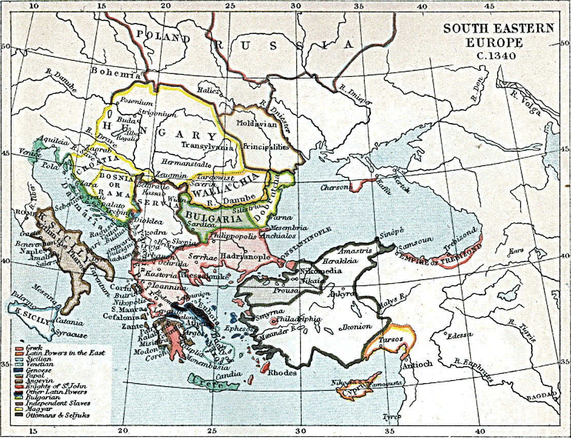
| Kirjeldus | South-East Europe in 1340 | ||||
| Kuupäev | |||||
| Allikas | [1] | ||||
| Autor | J.B. Bury, Longmans Green and Co | ||||
| Luba (Faili edasikasutus) |
|
||||
| Teised versioonid |
|
||||

Faili ajalugu
Klõpsa kuupäeva ja kellaaega, et näha sel ajahetkel kasutusel olnud failiversiooni.
| Kuupäev/kellaaeg | Pisipilt | Mõõtmed | Kasutaja | Kommentaar | |
|---|---|---|---|---|---|
| viimane | 11. juuli 2009, kell 11:10 | | 1113 × 854 (363 KB) | Spiridon Ion Cepleanu (arutelu | kaastöö) | Reverted to version as of 11:09, 11 July 2009 |
| 11. juuli 2009, kell 11:09 |  | 1113 × 854 (547 KB) | Spiridon Ion Cepleanu (arutelu | kaastöö) | Reverted to version as of 23:56, 5 December 2007 | |
| 11. juuli 2009, kell 11:09 |  | 1113 × 854 (363 KB) | Spiridon Ion Cepleanu (arutelu | kaastöö) | In 1340 Moldavia does't belong to Russia. Some little principalities (Barlad, Strasinets, Baia, Hansca) are mentionned by all sources and confirmed by archaeology. See : Gheorghe Postica : Civilizatia veche medievala din Moldova (Old medieval civilisation | |
| 11. juuli 2009, kell 11:03 |  | 1113 × 854 (363 KB) | Spiridon Ion Cepleanu (arutelu | kaastöö) | ||
| 11. juuli 2009, kell 10:58 |  | 1113 × 854 (363 KB) | Spiridon Ion Cepleanu (arutelu | kaastöö) | ||
| 5. detsember 2007, kell 23:56 |  | 1113 × 854 (547 KB) | Alex:D (arutelu | kaastöö) | {{Information |Description=South-East Europe in 1340 |Source=[http://historymedren.about.com/library/atlas/natmapeurse1340.htm] |Date=1903 |Author=J.B. Bury, Longmans Green and Co |Permission={{PD-Old}} |other_versions= }} Category:Maps of Europe [[Ca |
Sa ei saa seda faili üle kirjutada.
Faili kasutus
Seda faili kasutavad järgmised 3 lehekülge:
Globaalne failikasutus
Järgmised muud vikid kasutavad seda faili:
- Faili kasutus vikis bg.wikipedia.org
- Faili kasutus vikis en.wikipedia.org
- Faili kasutus vikis et.wikipedia.org
- Faili kasutus vikis fr.wikipedia.org
- Faili kasutus vikis he.wikipedia.org
- Faili kasutus vikis hu.wikipedia.org
- Faili kasutus vikis it.wikipedia.org
- Faili kasutus vikis pt.wikipedia.org
- Faili kasutus vikis ro.wikipedia.org
- Faili kasutus vikis ru.wikipedia.org
- Faili kasutus vikis sh.wikipedia.org
- Faili kasutus vikis sk.wikipedia.org
- Faili kasutus vikis sr.wikipedia.org
- Faili kasutus vikis uk.wikipedia.org
- Maps of the Byzantine empire in the 14th century
- Maps showing history of the Late Middle Ages
- Maps of 14th-century Europe
- Maps showing the 1340s
- Maps of the Kingdom of Serbia (medieval)
- Maps of the history of Croatia in the Middle Ages
- Maps of the history of Bulgaria in the Middle Ages
- Maps of the history of Romania in the Middle Ages
- Maps of the history of the medieval Balkans
- Atlas To Freeman's Historical Geography
- Maps of medieval Bosnian and neighboring states
- Maps of the Ottoman Empire in the 14th century