File:Southern Patagonian Ice Field (MODIS 2022-08-11).jpg

Original file (3,557 × 2,836 pixels, file size: 1.88 MB, MIME type: image/jpeg)
Captions
Captions
Summary
[edit].jpg&action=edit§ion=1)
| Description |
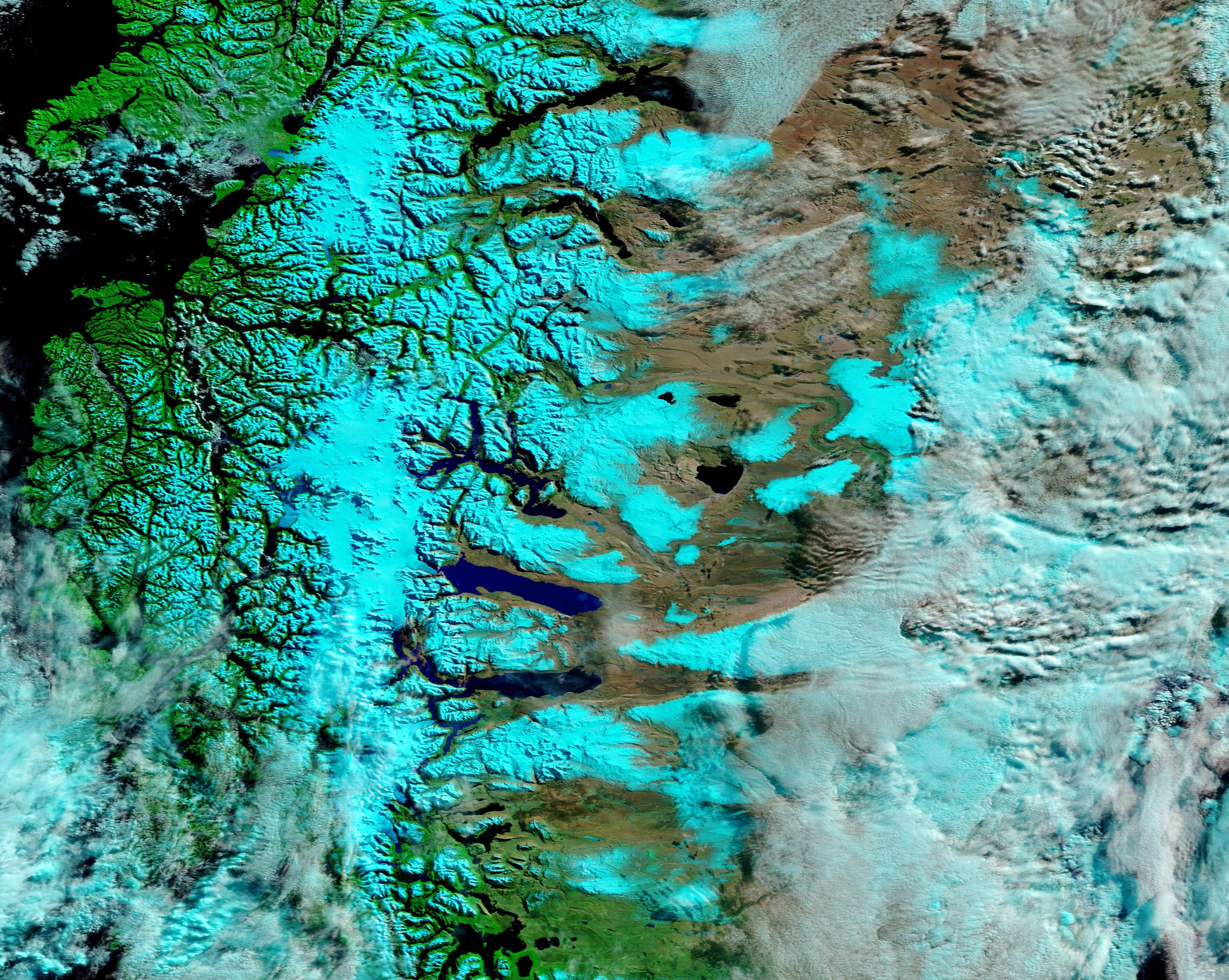
English: The vast Patagonian icefields ride atop South America’s Andes Mountains, straddling the border between Chile (west) and Argentina (east). Divided into two long lobes, the North and South Patagonian icefields, they are dramatically expansive, but have been shrinking. The icefields reached maximum size about 18,000 years ago and have very slowly shrunken to their current size. Today the Southern Patagonian icefield measures about 13,000 square kilometers (5,020 square miles), about three times the size of the Northern icefield. Altogether, the icy area spans about 17,333 square kilometers (6,692 square miles)—that is just a bit smaller than the U.S. state of New Jersey.
On August 5, 2022, the Moderate Resolution Imaging Spectroradiometer (MODIS) on board NASA’s Aqua satellite acquired a false-color image of the Southern Patagonia icefield. Such expansive views of the icy region are rare, thanks to the frequent clouds that cover the southern Andes. This type of false-color image combines infrared and visible light (MODIS bands 7-2-1) to highlight snow and ice, which appear bright electric blue. Vegetation looks green and open Earth, or areas with little vegetation, are colored in tans and brown. Water may appear deep blue or black and cloud often appears white, although high, cold cloud that contains ice will be tinted in electric blue. With these colors, it is easy to see snow across the Andes as well on the Argentinian Pampas to the east. Glaciers are solid stretches of ice, often topped with substantial snow in the wintertime, and stand out against the snow. On the eastern side of the Andes, numerous glacial lakes, filled with water from melting glaciers, extend from the edge of the Andes eastward. Although it has taken thousands of years for the Patagonian icefields to shrink to their current size, like most glaciers around the world, the Southern Patagonian icefield has been retreating more quickly recently in the face of rising atmospheric and ocean temperatures. According to the University of Maine Climate Change Institute, the Southern Patagonian Icefield is particularly susceptible to a changing climate because of its relative proximity to the equator and because it is made up of low-elevation alpine and tidewater glaciers that are highly sensitive to changes in temperature and precipitation. |
||
| Date | Taken on 5 August 2022 | ||
| Source |
Southern Patagonian Ice Field (direct link)
|
||
| Author | MODIS Land Rapid Response Team, NASA GSFC |
| This media is a product of the Terra mission Credit and attribution belongs to the mission team, if not already specified in the "author" row |
Licensing
[edit].jpg&action=edit§ion=2)
| This file is in the public domain in the United States because it was solely created by NASA. NASA copyright policy states that "NASA material is not protected by copyright unless noted". (See Template:PD-USGov, NASA copyright policy page or JPL Image Use Policy.) | ||
 |
Warnings:
|
File history
Click on a date/time to view the file as it appeared at that time.
| Date/Time | Thumbnail | Dimensions | User | Comment | |
|---|---|---|---|---|---|
| current | 21:53, 9 January 2024 | | 3,557 × 2,836 (1.88 MB) | OptimusPrimeBot (talk | contribs) | #Spacemedia - Upload of http://modis.gsfc.nasa.gov/gallery/images/image08112022_250m.jpg via Commons:Spacemedia |
You cannot overwrite this file.
File usage on Commons
There are no pages that use this file.
.jpg&oldid=840280655)