File:Southern Whidbey Island fault-1.png
Jump to navigation
Jump to search
No higher resolution available.
Southern_Whidbey_Island_fault-1.png (406 × 361 pixels, file size: 657 KB, MIME type: image/png)
Captions
Captions
Add a one-line explanation of what this file represents
Summary[edit]
| Description |
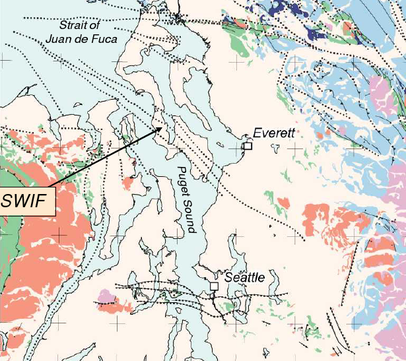
English: Location and known extent (prior to 2004) of the Southern Widbey Island Fault zone (SWIF) and various other unlabeled faults in the eastern Strait of Juan de Fuca and northern Puget Sound region (Washington). |
|||
| Date | ||||
| Source | https://earthquake.usgs.gov/hazards/about/workshops/PacNWworkshoptalks/Blakely_presentationSWIF.pdf | |||
| Author | R. Blakely (USGS) Presentation at USGS National Seismic Hazard Maps Pacific Northwest Workshop March 28-29, 2006 | |||
| Permission (Reusing this file) |
|
Licensing[edit]
This image is in the public domain in the United States because it only contains materials that originally came from the United States Geological Survey, an agency of the United States Department of the Interior. For more information, see the official USGS copyright policy.
|
File history
Click on a date/time to view the file as it appeared at that time.
| Date/Time | Thumbnail | Dimensions | User | Comment | |
|---|---|---|---|---|---|
| current | 19:39, 5 June 2010 | | 406 × 361 (657 KB) | J. Johnson (talk | contribs) | {{Information |Description={{en|1=Location and known extent (prior to 2004) of the Southern Widbey Island Fault zone (SWIF) and various other unlabeled faults in the eastern Strait of Juan de Fuca and northern Puget Sound region (Washington). }} |Source=h |
You cannot overwrite this file.
File usage on Commons
There are no pages that use this file.
File usage on other wikis
The following other wikis use this file:
- Usage on de.wikipedia.org
- Usage on en.wikipedia.org