File:Southwest Madagascar (MODIS 2022-02-18).jpg

Original file (1,568 × 1,208 pixels, file size: 235 KB, MIME type: image/jpeg)
Captions
Captions
Summary
[edit].jpg&action=edit§ion=1)
| Description |
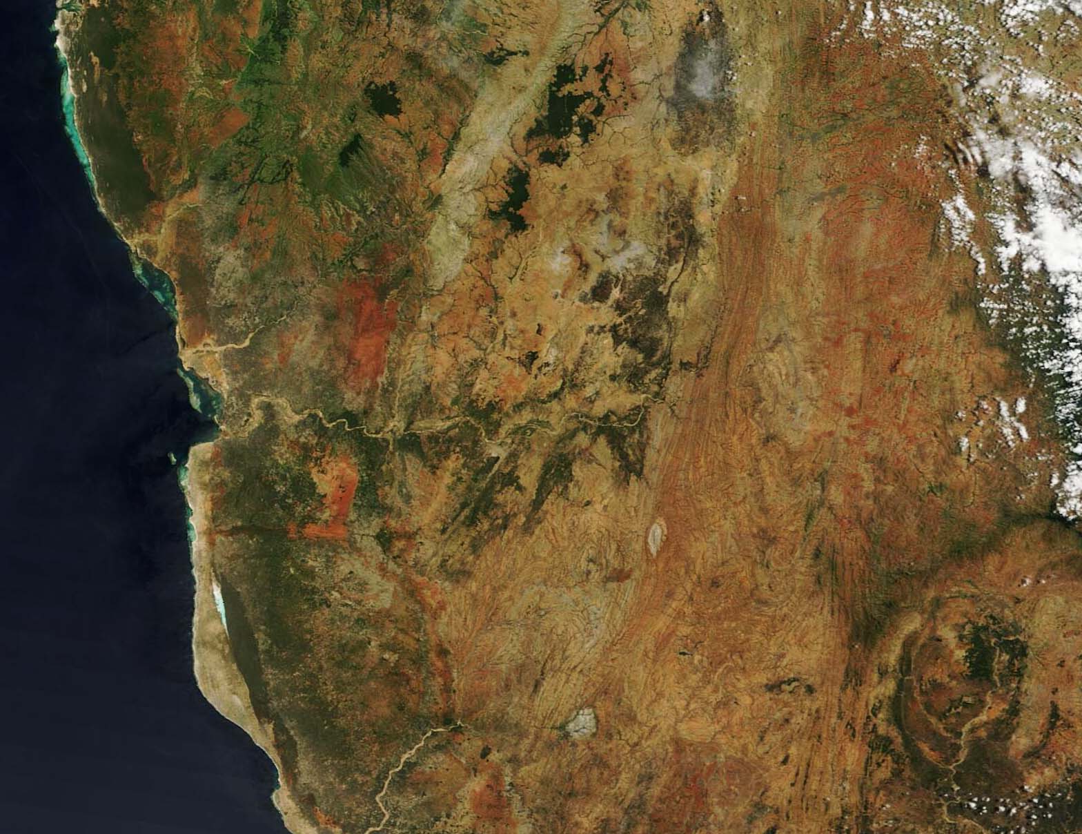
English: Southwestern Madagascar’s spectacular colors, ranging from salty white, to ferruginous red, to deep greens, created a beautiful and complicated mosaic when viewed from space. On February 16, 2022, the Moderate Resolution Imaging Spectroradiometer (MODIS) on board NASA’s Terra satellite acquired a true-color image of this semi-arid region.
Sitting about 830 km (515 miles) off of the eastern African coast, much of Southwestern Madagascar receives less than 75 mm (3 inches) of rain annually. Most of this falls during the rainy season, which runs from December through February, leaving the remainder of the year extremely dry. With little rain, warm temperatures, and rugged terrain, a unique ecosystem has developed. Known as the Madagascar spiny forest, it is the region with the highest plant endemism in Madagascar, with about 95 of the plant species found nowhere else. Animal endemism is also high, with species such as the endangered Grandidier’s Mongoose unique to the region, and more than thirty-five species of endemic birds. Much of Madagascar has been suffering from extended drought conditions, including parts of the southwestern region. Since the beginning of 2022, however, the island has been battered by a number of devastating storms. Tropical Storm Ana struck the southeastern coast on January 24, impacting 185,429 people, injured 207 people, and killed at least 38 people. It also destroyed 11,757 houses and damaged 26 health centers, and 25 water supply systems, according to ReliefWeb. This was followed by landfall of Tropical Cyclone Batsirai, again on the southeastern coast, which affected 270,900 people and killed 120 as the storm travelled across southwestward the country, passing over the area in today’s image before moving over the Mozambique Channel. Ten days after Tropical Cyclone Batsirai struck the southeast coast, Tropical Storm Dumako made landfall on the northeast coast of the country on February 15. Two people are missing, at least 5,100 people have been directly affected by that storm. On February 17, a new a new weather system— Tropical Storm Emnati—formed in the Indian Ocean. Although the trajectory and potential impact are still uncertain, it is continuing to intensify, and it is forecast to strike the east coast of Madagascar around February 22. |
||
| Date | Taken on 16 February 2022 | ||
| Source |
Southwest Madagascar (direct link)
|
||
| Author | MODIS Land Rapid Response Team, NASA GSFC |
| This media is a product of the Terra mission Credit and attribution belongs to the mission team, if not already specified in the "author" row |
Licensing
[edit].jpg&action=edit§ion=2)
| This file is in the public domain in the United States because it was solely created by NASA. NASA copyright policy states that "NASA material is not protected by copyright unless noted". (See Template:PD-USGov, NASA copyright policy page or JPL Image Use Policy.) | ||
 |
Warnings:
|
File history
Click on a date/time to view the file as it appeared at that time.
| Date/Time | Thumbnail | Dimensions | User | Comment | |
|---|---|---|---|---|---|
| current | 22:16, 9 January 2024 | | 1,568 × 1,208 (235 KB) | OptimusPrimeBot (talk | contribs) | #Spacemedia - Upload of http://modis.gsfc.nasa.gov/gallery/images/image02182022_250m.jpg via Commons:Spacemedia |
You cannot overwrite this file.
File usage on Commons
There are no pages that use this file.
.jpg&oldid=840280770)