File:Soviet Union Administrative Divisions 1989.jpg
跳转到导航
跳转到搜索

本预览的尺寸:800 × 557像素。 其他分辨率:320 × 223像素 | 640 × 445像素 | 1,024 × 713像素 | 1,280 × 891像素 | 1,887 × 1,313像素。
原始文件 (1,887 × 1,313像素,文件大小:397 KB,MIME类型:image/jpeg)
说明
说明
添加一行文字以描述该文件所表现的内容
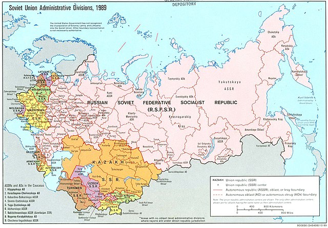
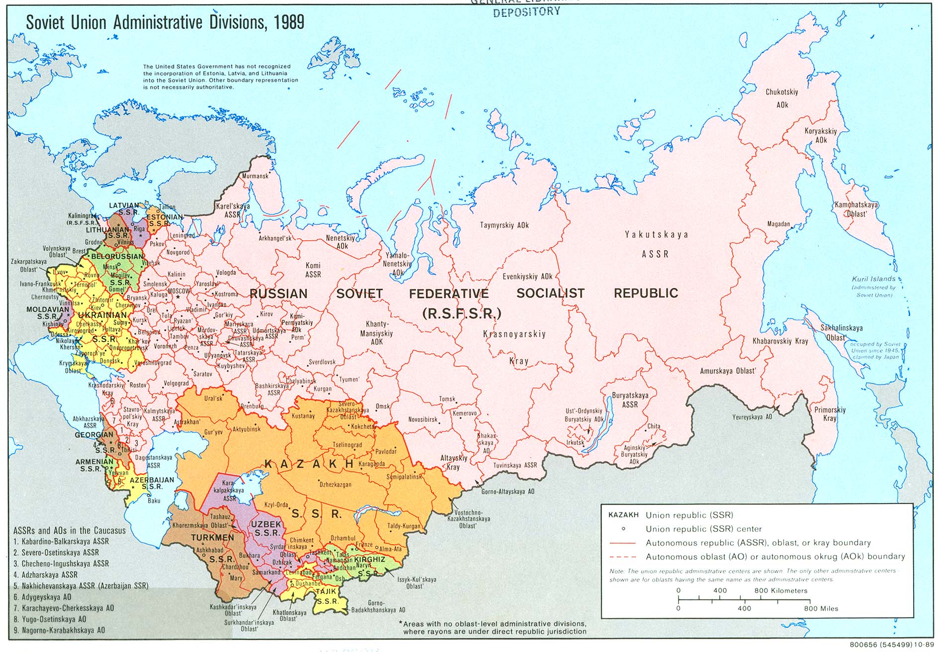
An American map of Soviet Union Administrative Divisions c.1989
摘要
[编辑]| 描述 |
English: An American map of Soviet Union Administrative Divisions c.1989 |
||
| 来源 |
|
||
| 作者 | |||
| 其他版本 |
|


许可协议
[编辑]
| This work is from the 美国国会图书馆. According to the library, there are no known copyright restrictions on the use of this work. |  |
文件历史
点击某个日期/时间查看对应时刻的文件。
| 日期/时间 | 缩略图 | 大小 | 用户 | 备注 | |
|---|---|---|---|---|---|
| 当前 | 2019年5月17日 (五) 14:21 | | 1,887 × 1,313(397 KB) | Claude Zygiel(留言 | 贡献) | Removed stains |
| 2006年12月17日 (日) 07:39 |  | 1,887 × 1,313(413 KB) | Electionworld(留言 | 贡献) | {{ew|en|Ma GioZal}} Soviet Union administrative divisions (republics) and sub-divisions (oblasts, autonomous republics, autonomous districs, etc.) in the year 1989, the last before the process of independence of Soviet republics after the [[Berlin Wa |
您不可以覆盖此文件。
文件用途
以下13个页面使用本文件:
全域文件用途
以下其他wiki使用此文件:
- af.wikipedia.org上的用途
- ar.wikipedia.org上的用途
- ast.wikipedia.org上的用途
- azb.wikipedia.org上的用途
- az.wikipedia.org上的用途
- az.wiktionary.org上的用途
- bg.wikipedia.org上的用途
- ca.wikipedia.org上的用途
- cs.wikipedia.org上的用途
- en.wikipedia.org上的用途
- History of the Soviet Union (1982–1991)
- History of Russia
- Republics of the Soviet Union
- Buryats
- History of Ukraine
- Ukrainian Soviet Socialist Republic
- Uzbek Soviet Socialist Republic
- Republics of Russia
- Soviet people
- Portal:Maps/Maps/Political
- Portal:Maps/Maps/Political/8
- User:Seryo93/USSR
- Russian Soviet Federative Socialist Republic
- Great Russian chauvinism
- Russia–Ukraine border
- Russian imperialism
- User:Falcaorib/Russia and Soviet Union
- en.wikiquote.org上的用途
- es.wikipedia.org上的用途
- fa.wikipedia.org上的用途
- fi.wikipedia.org上的用途
查看此文件的更多全域用途。