File:Soviet caucasus1922.png
Naviqasiyaya keç
Axtarışa keç

Sınaq göstərişi ölçüsü: 800 × 571 piksel. Digər ölçülər: 320 × 229 piksel | 640 × 457 piksel | 1.024 × 731 piksel | 1.280 × 914 piksel | 1.613 × 1.152 piksel.
Faylın orijinalı (1.613 × 1.152 piksel, fayl həcmi: 127 KB, MIME növü: image/png)
Captions
Captions
Add a one-line explanation of what this file represents
Xülasə[redaktə]
| İzah |
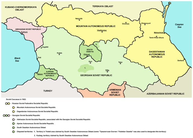
English: Northern part of Soviet Caucasus in 1922 - Mountain Autonomous Soviet Socialist Republic, Dagestanian Autonomous Soviet Socialist Republic, Georgian Soviet Socialist Republic, Abkhazian Soviet Socialist Republic, Ajarian Autonomous Soviet Socialist Republic, South Ossetian Autonomous Oblast and disputed territories claimed by South Ossetian Autonomous Oblast (Trialeti area / Trialetian Ossetia and Kazbeg). |
| Tarix | |
| Mənbə | Öz işi |
| Müəllif | PANONIAN |
| Digər versiyalar |
|

Lisenziya[redaktə]
| Mən, bu əsərin müəllif hüquqlarının sahibi kimi, əsəri ictimai mülkiyyətə verirəm. Bu icazə bütün dünyada qüvvədədir. In some countries this may not be legally possible; if so: Bunun qanunla mümkün olmadığı hallarda: İstənilən şəxsə, istənilən məqsəd üçün, qanunlar tərəfindən qadağan edilməyincə, heç bir şərt qoymadan bu işdən istifadə haqqını bağışlayıram. |
References[redaktə]
Made according to these sources:
- http://www.iriston.com/books/cuciev_-_etno_atlas/cuciev_etno-polit_map.htm - 50 maps from book "АТЛАС ЭТНОПОЛИТИЧЕСКОЙ ИСТОРИИ КАВКАЗА", Цуциев А.А, Москва: Издательство «Европа», 2007. ("Atlas of ethnopolitical history of Caucasus", Tsutsiev A.A, Moscow: Publisher «Evropa», 2007), inluding a map of Soviet Caucasus in 1921, which show Mountain Autonomous Soviet Socialist Republic, Dagestanian Autonomous Soviet Socialist Republic, Georgian Soviet Socialist Republic, Abkhazian Soviet Socialist Republic, Ajarian Autonomous Soviet Socialist Republic, and disputed territories inhabited by Ossetians: South Ossetia, Trialetian Ossetia and Kazbeg.
- http://dic.academic.ru/pictures/wiki/files/84/Tsutsiev.jpg - map from book "АТЛАС ЭТНОПОЛИТИЧЕСКОЙ ИСТОРИИ КАВКАЗА", Цуциев А.А ("Atlas of ethnopolitical history of Caucasus", Tsutsiev A.A), inluding a map of Soviet Caucasus in 1921, which show Mountain Autonomous Soviet Socialist Republic, Dagestanian Autonomous Soviet Socialist Republic, Georgian Soviet Socialist Republic, Abkhazian Soviet Socialist Republic, Ajarian Autonomous Soviet Socialist Republic, and disputed territories inhabited by Ossetians: South Ossetia, Trialetian Ossetia and Kazbeg.
- http://www.iriston.com/nogbon/pictures/Tabol/cuciev_karta_6.jpg - map of Soviet Caucasus in 1922, created by Tsutsiev A.A, which show Mountain Autonomous Soviet Socialist Republic and South Ossetian Autonomous Oblast.
Faylın tarixçəsi
Faylın əvvəlki versiyasını görmək üçün gün/tarix bölməsindəki tarixlərə klikləyin.
| Tarix/Vaxt | Kiçik şəkil | Ölçülər | İstifadəçi | Şərh | |
|---|---|---|---|---|---|
| indiki | 17:03, 26 dekabr 2015 | | 1.613 × 1.152 (127 KB) | PANONIAN (müzakirə | töhfələr) | Reverted to version as of 14:47, 27 March 2010 (UTC) - please upload your version under different filename |
| 10:56, 26 dekabr 2015 |  | 1.613 × 1.090 (115 KB) | Ercwlff (müzakirə | töhfələr) | corrected georgian city names | |
| 10:45, 26 dekabr 2015 |  | 1.613 × 1.090 (114 KB) | Ercwlff (müzakirə | töhfələr) | corrected | |
| 10:42, 26 dekabr 2015 |  | 1.613 × 1.090 (117 KB) | Ercwlff (müzakirə | töhfələr) | ~~~~ | |
| 14:47, 27 mart 2010 |  | 1.613 × 1.152 (127 KB) | PANONIAN (müzakirə | töhfələr) | on the second thought, this map is focused on the history of Ossetians and other north Caucasian peoples and therefore disputes areas claimed by Armenia and Azerbaijan are not very relevant subject here | |
| 22:04, 26 mart 2010 |  | 1.613 × 1.216 (134 KB) | PANONIAN (müzakirə | töhfələr) | corrected one description | |
| 22:54, 25 mart 2010 |  | 1.613 × 1.216 (132 KB) | PANONIAN (müzakirə | töhfələr) | new version | |
| 23:52, 23 mart 2010 |  | 1.613 × 1.122 (121 KB) | PANONIAN (müzakirə | töhfələr) | correction | |
| 18:51, 23 mart 2010 |  | 1.613 × 1.122 (121 KB) | PANONIAN (müzakirə | töhfələr) | significant improvement - I hope that this is a final version | |
| 16:32, 23 mart 2010 |  | 1.227 × 915 (88 KB) | PANONIAN (müzakirə | töhfələr) | corrections |
Siz bu faylı yenidən yükləyə bilməzsiniz.
Fayl keçidləri
Aşağıdakı 8 səhifə bu faylı istifadə edir:
Faylın qlobal istifadəsi
Bu fayl aşağıdakı vikilərdə istifadə olunur:
- ar.wikipedia.org layihəsində istifadəsi
- ast.wikipedia.org layihəsində istifadəsi
- bg.wikipedia.org layihəsində istifadəsi
- bn.wikipedia.org layihəsində istifadəsi
- br.wikipedia.org layihəsində istifadəsi
- ca.wikipedia.org layihəsində istifadəsi
- ce.wikipedia.org layihəsində istifadəsi
- de.wikipedia.org layihəsində istifadəsi
- en.wikipedia.org layihəsində istifadəsi
- eo.wikipedia.org layihəsində istifadəsi
- es.wikipedia.org layihəsində istifadəsi
- et.wikipedia.org layihəsində istifadəsi
- fi.wikipedia.org layihəsində istifadəsi
- fr.wikipedia.org layihəsində istifadəsi
- it.wikipedia.org layihəsində istifadəsi
- ja.wikipedia.org layihəsində istifadəsi
- kk.wikipedia.org layihəsində istifadəsi
- ko.wikipedia.org layihəsində istifadəsi
- ku.wikipedia.org layihəsində istifadəsi
- lt.wikipedia.org layihəsində istifadəsi
- lv.wikipedia.org layihəsində istifadəsi
- mk.wikipedia.org layihəsində istifadəsi
- no.wikipedia.org layihəsində istifadəsi
- os.wikipedia.org layihəsində istifadəsi
- pl.wikipedia.org layihəsində istifadəsi
Bu faylın qlobal istifadəsinə baxın.
Kateqoriyalar:
- Maps of the history of the Caucasus under Soviet rule
- Maps of the history of Russia
- Maps of the history of Karachay-Cherkessia
- Maps of the history of Kabardino-Balkaria
- Maps of the history of North Ossetia – Alania
- Maps of the history of Chechnya
- Maps of the history of Dagestan
- Maps of the history of Georgia
- Maps of the history of Abkhazia
- Maps of the history of Ajaria
- Maps of the history of South Ossetia
- Maps of the Georgian Soviet Socialist Republic
- 1922 maps
- Maps of the Caucasus by some users