File:Soviet caucasus1922.png
Zur Navigation springen
Zur Suche springen

Größe dieser Vorschau: 800 × 571 Pixel. Weitere Auflösungen: 320 × 229 Pixel | 640 × 457 Pixel | 1.024 × 731 Pixel | 1.280 × 914 Pixel | 1.613 × 1.152 Pixel.
Originaldatei (1.613 × 1.152 Pixel, Dateigröße: 127 KB, MIME-Typ: image/png)
Bildtexte
Kurzbeschreibungen
Ergänze eine einzeilige Erklärung, was diese Datei darstellt.
Beschreibung
[Bearbeiten]| Beschreibung |
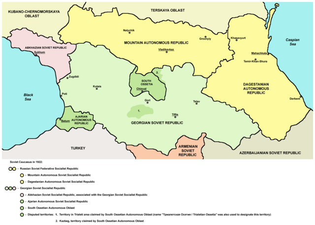
English: Northern part of Soviet Caucasus in 1922 - Mountain Autonomous Soviet Socialist Republic, Dagestanian Autonomous Soviet Socialist Republic, Georgian Soviet Socialist Republic, Abkhazian Soviet Socialist Republic, Ajarian Autonomous Soviet Socialist Republic, South Ossetian Autonomous Oblast and disputed territories claimed by South Ossetian Autonomous Oblast (Trialeti area / Trialetian Ossetia and Kazbeg). |
| Datum | |
| Quelle | Eigenes Werk |
| Urheber | PANONIAN |
| Andere Versionen |
|

Lizenz
[Bearbeiten]
| Ich, der Urheberrechtsinhaber dieses Werkes, veröffentliche es als gemeinfrei. Dies gilt weltweit. In manchen Staaten könnte dies rechtlich nicht möglich sein. Sofern dies der Fall ist: Ich gewähre jedem das bedingungslose Recht, dieses Werk für jedweden Zweck zu nutzen, es sei denn, Bedingungen sind gesetzlich erforderlich. |
References
[Bearbeiten]
Made according to these sources:
- http://www.iriston.com/books/cuciev_-_etno_atlas/cuciev_etno-polit_map.htm - 50 maps from book "АТЛАС ЭТНОПОЛИТИЧЕСКОЙ ИСТОРИИ КАВКАЗА", Цуциев А.А, Москва: Издательство «Европа», 2007. ("Atlas of ethnopolitical history of Caucasus", Tsutsiev A.A, Moscow: Publisher «Evropa», 2007), inluding a map of Soviet Caucasus in 1921, which show Mountain Autonomous Soviet Socialist Republic, Dagestanian Autonomous Soviet Socialist Republic, Georgian Soviet Socialist Republic, Abkhazian Soviet Socialist Republic, Ajarian Autonomous Soviet Socialist Republic, and disputed territories inhabited by Ossetians: South Ossetia, Trialetian Ossetia and Kazbeg.
- http://dic.academic.ru/pictures/wiki/files/84/Tsutsiev.jpg - map from book "АТЛАС ЭТНОПОЛИТИЧЕСКОЙ ИСТОРИИ КАВКАЗА", Цуциев А.А ("Atlas of ethnopolitical history of Caucasus", Tsutsiev A.A), inluding a map of Soviet Caucasus in 1921, which show Mountain Autonomous Soviet Socialist Republic, Dagestanian Autonomous Soviet Socialist Republic, Georgian Soviet Socialist Republic, Abkhazian Soviet Socialist Republic, Ajarian Autonomous Soviet Socialist Republic, and disputed territories inhabited by Ossetians: South Ossetia, Trialetian Ossetia and Kazbeg.
- http://www.iriston.com/nogbon/pictures/Tabol/cuciev_karta_6.jpg - map of Soviet Caucasus in 1922, created by Tsutsiev A.A, which show Mountain Autonomous Soviet Socialist Republic and South Ossetian Autonomous Oblast.
Dateiversionen
Klicke auf einen Zeitpunkt, um diese Version zu laden.
| Version vom | Vorschaubild | Maße | Benutzer | Kommentar | |
|---|---|---|---|---|---|
| aktuell | 17:03, 26. Dez. 2015 | | 1.613 × 1.152 (127 KB) | WikiEditor2004 (Diskussion | Beiträge) | Reverted to version as of 14:47, 27 March 2010 (UTC) - please upload your version under different filename |
| 10:56, 26. Dez. 2015 |  | 1.613 × 1.090 (115 KB) | Ercwlff (Diskussion | Beiträge) | corrected georgian city names | |
| 10:45, 26. Dez. 2015 |  | 1.613 × 1.090 (114 KB) | Ercwlff (Diskussion | Beiträge) | corrected | |
| 10:42, 26. Dez. 2015 |  | 1.613 × 1.090 (117 KB) | Ercwlff (Diskussion | Beiträge) | ~~~~ | |
| 14:47, 27. Mär. 2010 |  | 1.613 × 1.152 (127 KB) | WikiEditor2004 (Diskussion | Beiträge) | on the second thought, this map is focused on the history of Ossetians and other north Caucasian peoples and therefore disputes areas claimed by Armenia and Azerbaijan are not very relevant subject here | |
| 22:04, 26. Mär. 2010 |  | 1.613 × 1.216 (134 KB) | WikiEditor2004 (Diskussion | Beiträge) | corrected one description | |
| 22:54, 25. Mär. 2010 |  | 1.613 × 1.216 (132 KB) | WikiEditor2004 (Diskussion | Beiträge) | new version | |
| 23:52, 23. Mär. 2010 |  | 1.613 × 1.122 (121 KB) | WikiEditor2004 (Diskussion | Beiträge) | correction | |
| 18:51, 23. Mär. 2010 |  | 1.613 × 1.122 (121 KB) | WikiEditor2004 (Diskussion | Beiträge) | significant improvement - I hope that this is a final version | |
| 16:32, 23. Mär. 2010 |  | 1.227 × 915 (88 KB) | WikiEditor2004 (Diskussion | Beiträge) | corrections |
Du kannst diese Datei nicht überschreiben.
Dateiverwendung
Die folgenden 8 Seiten verwenden diese Datei:
Globale Dateiverwendung
Die nachfolgenden anderen Wikis verwenden diese Datei:
- Verwendung auf ar.wikipedia.org
- Verwendung auf ast.wikipedia.org
- Verwendung auf bg.wikipedia.org
- Verwendung auf bn.wikipedia.org
- Verwendung auf br.wikipedia.org
- Verwendung auf ca.wikipedia.org
- Verwendung auf ce.wikipedia.org
- Verwendung auf de.wikipedia.org
- Verwendung auf en.wikipedia.org
- Verwendung auf eo.wikipedia.org
- Verwendung auf es.wikipedia.org
- Verwendung auf et.wikipedia.org
- Verwendung auf fi.wikipedia.org
- Verwendung auf fr.wikipedia.org
- Verwendung auf it.wikipedia.org
- Verwendung auf ja.wikipedia.org
- Verwendung auf kk.wikipedia.org
- Verwendung auf ko.wikipedia.org
- Verwendung auf ku.wikipedia.org
- Verwendung auf lt.wikipedia.org
- Verwendung auf lv.wikipedia.org
- Verwendung auf mk.wikipedia.org
- Verwendung auf no.wikipedia.org
- Verwendung auf os.wikipedia.org
- Verwendung auf pl.wikipedia.org
Weitere globale Verwendungen dieser Datei anschauen.
Kategorien:
- Maps of the history of the Caucasus under Soviet rule
- Maps of the history of Russia
- Maps of the history of Karachay-Cherkessia
- Maps of the history of Kabardino-Balkaria
- Maps of the history of North Ossetia – Alania
- Maps of the history of Chechnya
- Maps of the history of Dagestan
- Maps of the history of Georgia
- Maps of the history of Abkhazia
- Maps of the history of Ajaria
- Maps of the history of South Ossetia
- Maps of the Georgian Soviet Socialist Republic
- 1922 maps
- Maps of the Caucasus by some users