File:Spice Islands (Zanzibar highlighted).svg
Pāriet uz navigāciju
Pāriet uz meklēšanu

Size of this PNG preview of this SVG file: 486 × 599 pikseļi. Citi izmēri: 195 × 240 pikseļi | 389 × 480 pikseļi | 623 × 768 pikseļi | 831 × 1 024 pikseļi | 1 662 × 2 048 pikseļi | 512 × 631 pikseļi.
Sākotnējais fails (SVG fails, definētais izmērs 512 × 631 pikseļi, faila izmērs: 6,08 MB)
Captions
Captions
Pievieno vienas rindiņas aprakstu, ko šis fails attēlo
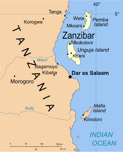
Map of Zanzibar
Kopsavilkums[labot šo sadaļu]
.svg&action=edit§ion=1)
| Apraksts | Part of the map of Tanzania, showing the Spice Islands, and highlighting Zanzibar. |
| Datums | |
| Avots | Vectors self-made in Inkscape. Source was cropped from 2003 Political map of Tanzania at Perry-Castañeda Library Map Collection — Tanzania. The maps are attributed to the US Central Intelligence Agency. |
| Autors | Mysid |
| Citas versijas |
Derivative works of this file: Image:Spice Islands (Tanzania).svgin French : Image:Spice_Islands_Tanzania-fr.svg in French : Image:Spice_Islands-Zanzibar_highlighted-fr.svg in Arabic: Image:Spice Islands (Zanzibar highlighted)-ar.svg |
| SVG veidošana |
_el.svg)
_sv.svg)
.svg)
-ar.svg)
Licence[labot šo sadaļu]
.svg&action=edit§ion=2)
| I, the copyright holder of this work, release this work into the public domain. This applies worldwide. In some countries this may not be legally possible; if so: I grant anyone the right to use this work for any purpose, without any conditions, unless such conditions are required by law. |
Faila hronoloģija
Uzklikšķini uz datums/laiks kolonnā esošās saites, lai apskatītos, kā šis fails izskatījās tad.
| Datums/Laiks | Attēls | Izmēri | Dalībnieks | Komentārs | |
|---|---|---|---|---|---|
| tagadējais | 2021. gada 9. oktobris, plkst. 02.16 | | 512 × 631 (6,08 MB) | Nwbeeson (diskusija | devums) | Zanzibar Island renamed to Unguja Island to match article caption |
| 2007. gada 6. janvāris, plkst. 20.09 |  | 713 × 879 (15 KB) | Mysid (diskusija | devums) | higlighting Pemba as well | |
| 2007. gada 6. janvāris, plkst. 20.06 |  | 713 × 879 (15 KB) | Mysid (diskusija | devums) | == Summary == {{Information |Description=Part of the map of Tanzania, showing the Spice Islands, and highlighting Zanzibar. |Source=Vectors self-made in Inkscape. Source was cropped from http://www.lib.utexas.edu/maps/africa/tanzania_p |
Šo failu nevar pārrakstīt.
Faila lietojums
Šo failu izmanto šajās 11 lapās:
- Atlas of colonialism
- Império Português
- Zanzibar
- File:Spice Islands (Zanzibar highlighted) el.svg
- File:Spice Islands (Zanzibar highlighted) sv.svg
- Category:1896 in Zanzibar
- Category:Buildings in Zanzibar
- Category:Geography of Zanzibar
- Category:Maps of Zanzibar
- Category:Zanzibar
- Category:Zanzibar by year
Globālais faila lietojums
Šīs Vikipēdijas izmanto šo failu:
- Izmantojums af.wikipedia.org
- Izmantojums ar.wikipedia.org
- Izmantojums ast.wikipedia.org
- Izmantojums ast.wiktionary.org
- Izmantojums azb.wikipedia.org
- Izmantojums az.wikipedia.org
- Izmantojums ba.wikipedia.org
- Izmantojums bg.wikipedia.org
- Izmantojums bn.wikipedia.org
- Izmantojums br.wikipedia.org
- Izmantojums ca.wikipedia.org
- Izmantojums cs.wikipedia.org
- Izmantojums de.wikipedia.org
- Izmantojums en.wikipedia.org
- Izmantojums eo.wikipedia.org
- Izmantojums eu.wikipedia.org
- Izmantojums fa.wikipedia.org
- Izmantojums fiu-vro.wikipedia.org
- Izmantojums fr.wikipedia.org
- Izmantojums gd.wikipedia.org
- Izmantojums gl.wikipedia.org
- Izmantojums ha.wikipedia.org
- Izmantojums hr.wikipedia.org
- Izmantojums hy.wikipedia.org
- Izmantojums id.wikipedia.org
- Izmantojums it.wikipedia.org
- Izmantojums it.wikivoyage.org
- Izmantojums ja.wikipedia.org
- Izmantojums ka.wikipedia.org
- Izmantojums ko.wikipedia.org
- Izmantojums ku.wikipedia.org
- Izmantojums lt.wikipedia.org
- Izmantojums lv.wikipedia.org
- Izmantojums mg.wikipedia.org
- Izmantojums nl.wikipedia.org
Skatīt šī faila pilno globālo izmantojumu.
.svg)
.svg&oldid=837437197)