File:Spice Islands (Zanzibar highlighted).svg
Sautar la navigacion
Sautar la recèrca

Talha d'aquesta previsualizacion PNG per aquest fichièr SVG: 486 × 599 pixèls. Autras resolucions : 195 × 240 pixèls | 389 × 480 pixèls | 623 × 768 pixèls | 831 × 1 024 pixèls | 1 662 × 2 048 pixèls | 512 × 631 pixèls.
Fichièr d'origina (Fichièr SVG, resolucion de 512 × 631 pixèls, talha : 6,08 Mo)
Llegendes
Llegendes
Afegeix una explicació d'una línia del que representa aquest fitxer
Map of Zanzibar
Descripcion
[modificar].svg&action=edit§ion=1)
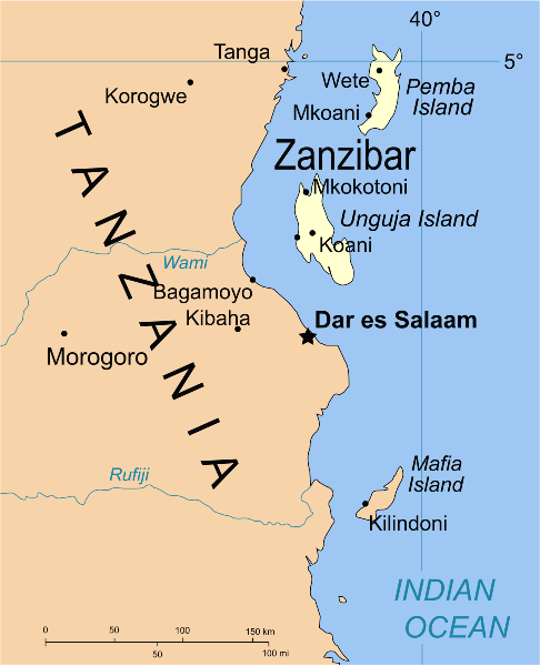
| Descripcion | Part of the map of Tanzania, showing the Spice Islands, and highlighting Zanzibar. |
| Data | |
| Font | Vectors self-made in Inkscape. Source was cropped from 2003 Political map of Tanzania at Perry-Castañeda Library Map Collection — Tanzania. The maps are attributed to the US Central Intelligence Agency. |
| Autor | Mysid |
| Autras versions |
Derivative works of this file: Image:Spice Islands (Tanzania).svgin French : Image:Spice_Islands_Tanzania-fr.svg in French : Image:Spice_Islands-Zanzibar_highlighted-fr.svg in Arabic: Image:Spice Islands (Zanzibar highlighted)-ar.svg |
| SVG information | El codi font d’aquest SVG no és vàlid perquè hi 2 han errors. Aqueste imatge vectorial es estat creat amb CorelDRAW Cette carte SVG utilise du texte encapsulé qui peut être traduit facilement à l'aide d'un éditeur de texte. |
_el.svg)
_sv.svg)
.svg)
-ar.svg)
Publicat jos licéncia(s)
[modificar].svg&action=edit§ion=2)
| Jo, el titular del copyright d'aquesta obra, l'allibero al domini públic. Això s'aplica a tot el món. En alguns països això pot no ser legalment possible, en tal cas: Jo faig concessió a tothom del dret d'usar aquesta obra per a qualsevol propòsit, sense cap condició llevat d'aquelles requerides per la llei. |
Istoric del fichièr
Clicar sus una data e una ora per veire lo fichièr tal coma èra a aqueste moment
| Data e ora | Miniatura | Dimensions | Utilizaire | Comentari | |
|---|---|---|---|---|---|
| actual | 9 octobre de 2021 a 02.16 | | 512 × 631 (6,08 Mo) | Nwbeeson (discussion | contribucions) | Zanzibar Island renamed to Unguja Island to match article caption |
| 6 genièr de 2007 a 20.09 |  | 713 × 879 (15 Ko) | Mysid (discussion | contribucions) | higlighting Pemba as well | |
| 6 genièr de 2007 a 20.06 |  | 713 × 879 (15 Ko) | Mysid (discussion | contribucions) | == Summary == {{Information |Description=Part of the map of Tanzania, showing the Spice Islands, and highlighting Zanzibar. |Source=Vectors self-made in Inkscape. Source was cropped from http://www.lib.utexas.edu/maps/africa/tanzania_p |
Podètz pas remplaçar aqueste fichièr.
Paginas que contenon lo fichièr
Las paginas çaijós compòrtan aqueste imatge :
- Atlas of colonialism
- Império Português
- Zanzibar
- File:Spice Islands (Zanzibar highlighted) el.svg
- File:Spice Islands (Zanzibar highlighted) sv.svg
- Category:1896 in Zanzibar
- Category:Buildings in Zanzibar
- Category:Geography of Zanzibar
- Category:Maps of Zanzibar
- Category:Zanzibar
- Category:Zanzibar by year
Usatge global del fichièr
Los autres wikis seguents utilizan aqueste imatge :
- Utilizacion sus af.wikipedia.org
- Utilizacion sus ar.wikipedia.org
- Utilizacion sus ast.wikipedia.org
- Utilizacion sus ast.wiktionary.org
- Utilizacion sus azb.wikipedia.org
- Utilizacion sus az.wikipedia.org
- Utilizacion sus ba.wikipedia.org
- Utilizacion sus bg.wikipedia.org
- Utilizacion sus bn.wikipedia.org
- Utilizacion sus br.wikipedia.org
- Utilizacion sus ca.wikipedia.org
- Utilizacion sus cs.wikipedia.org
- Utilizacion sus de.wikipedia.org
- Utilizacion sus en.wikipedia.org
- Utilizacion sus eo.wikipedia.org
- Utilizacion sus eu.wikipedia.org
- Utilizacion sus fa.wikipedia.org
- Utilizacion sus fiu-vro.wikipedia.org
- Utilizacion sus fr.wikipedia.org
- Utilizacion sus gd.wikipedia.org
- Utilizacion sus gl.wikipedia.org
- Utilizacion sus ha.wikipedia.org
- Utilizacion sus hr.wikipedia.org
- Utilizacion sus hy.wikipedia.org
- Utilizacion sus id.wikipedia.org
- Utilizacion sus it.wikipedia.org
- Utilizacion sus it.wikivoyage.org
- Utilizacion sus ja.wikipedia.org
- Utilizacion sus ka.wikipedia.org
- Utilizacion sus ko.wikipedia.org
- Utilizacion sus ku.wikipedia.org
- Utilizacion sus lt.wikipedia.org
- Utilizacion sus lv.wikipedia.org
- Utilizacion sus mg.wikipedia.org
- Utilizacion sus nl.wikipedia.org
Veire l'utilizacion globala d'aqueste fichièr.
.svg)
.svg&oldid=837437197)