File:Spice Islands (Zanzibar highlighted).svg
跳至導覽
跳至搜尋

此 SVG 檔案的 PNG 預覽的大小:486 × 599 像素。 其他解析度:195 × 240 像素 | 389 × 480 像素 | 623 × 768 像素 | 831 × 1,024 像素 | 1,662 × 2,048 像素 | 512 × 631 像素。
原始檔案 (SVG 檔案,表面大小:512 × 631 像素,檔案大小:6.08 MB)
說明
說明
添加單行說明來描述出檔案所代表的內容
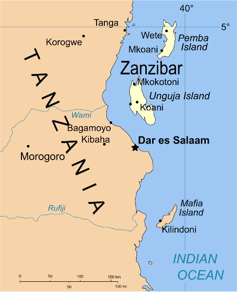
Map of Zanzibar
摘要
[編輯].svg&action=edit§ion=1)
| 描述 | Part of the map of Tanzania, showing the Spice Islands, and highlighting Zanzibar. |
| 日期 | |
| 來源 | Vectors self-made in Inkscape. Source was cropped from 2003 Political map of Tanzania at Perry-Castañeda Library Map Collection — Tanzania. The maps are attributed to the US Central Intelligence Agency. |
| 作者 | Mysid |
| 其他版本 |
Derivative works of this file: Image:Spice Islands (Tanzania).svgin French : Image:Spice_Islands_Tanzania-fr.svg in French : Image:Spice_Islands-Zanzibar_highlighted-fr.svg in Arabic: Image:Spice Islands (Zanzibar highlighted)-ar.svg |
| SVG開發 |
_el.svg)
_sv.svg)
.svg)
-ar.svg)
授權條款
[編輯].svg&action=edit§ion=2)
| 我,此作品的版權所有人,釋出此作品至公共領域。此授權條款在全世界均適用。 這可能在某些國家不合法,如果是的話: 我授予任何人有權利使用此作品於任何用途,除受法律約束外,不受任何限制。 |
檔案歷史
點選日期/時間以檢視該時間的檔案版本。
| 日期/時間 | 縮圖 | 尺寸 | 用戶 | 備註 | |
|---|---|---|---|---|---|
| 目前 | 2021年10月9日 (六) 02:16 | | 512 × 631(6.08 MB) | Nwbeeson(對話 | 貢獻) | Zanzibar Island renamed to Unguja Island to match article caption |
| 2007年1月6日 (六) 20:09 |  | 713 × 879(15 KB) | Mysid(對話 | 貢獻) | higlighting Pemba as well | |
| 2007年1月6日 (六) 20:06 |  | 713 × 879(15 KB) | Mysid(對話 | 貢獻) | == Summary == {{Information |Description=Part of the map of Tanzania, showing the Spice Islands, and highlighting Zanzibar. |Source=Vectors self-made in Inkscape. Source was cropped from http://www.lib.utexas.edu/maps/africa/tanzania_p |
無法覆蓋此檔案。
檔案用途
下列11個頁面有用到此檔案:
- Atlas of colonialism
- Império Português
- Zanzibar
- File:Spice Islands (Zanzibar highlighted) el.svg
- File:Spice Islands (Zanzibar highlighted) sv.svg
- Category:1896 in Zanzibar
- Category:Buildings in Zanzibar
- Category:Geography of Zanzibar
- Category:Maps of Zanzibar
- Category:Zanzibar
- Category:Zanzibar by year
全域檔案使用狀況
以下其他 wiki 使用了這個檔案:
- af.wikipedia.org 的使用狀況
- ar.wikipedia.org 的使用狀況
- ast.wikipedia.org 的使用狀況
- ast.wiktionary.org 的使用狀況
- azb.wikipedia.org 的使用狀況
- az.wikipedia.org 的使用狀況
- ba.wikipedia.org 的使用狀況
- bg.wikipedia.org 的使用狀況
- bn.wikipedia.org 的使用狀況
- br.wikipedia.org 的使用狀況
- ca.wikipedia.org 的使用狀況
- cs.wikipedia.org 的使用狀況
- de.wikipedia.org 的使用狀況
- en.wikipedia.org 的使用狀況
- eo.wikipedia.org 的使用狀況
- eu.wikipedia.org 的使用狀況
- fa.wikipedia.org 的使用狀況
- fiu-vro.wikipedia.org 的使用狀況
- fr.wikipedia.org 的使用狀況
- gd.wikipedia.org 的使用狀況
- gl.wikipedia.org 的使用狀況
- ha.wikipedia.org 的使用狀況
- hr.wikipedia.org 的使用狀況
- hy.wikipedia.org 的使用狀況
- id.wikipedia.org 的使用狀況
- it.wikipedia.org 的使用狀況
- it.wikivoyage.org 的使用狀況
- ja.wikipedia.org 的使用狀況
- ka.wikipedia.org 的使用狀況
- ko.wikipedia.org 的使用狀況
- ku.wikipedia.org 的使用狀況
- lt.wikipedia.org 的使用狀況
- lv.wikipedia.org 的使用狀況
- mg.wikipedia.org 的使用狀況
- nl.wikipedia.org 的使用狀況
檢視此檔案的更多全域使用狀況。
.svg)
.svg&oldid=837437197)