File:Stöbberquelle.png
Jump to navigation
Jump to search
Size of this preview: 555 × 599 pixels. Other resolutions: 222 × 240 pixels | 445 × 480 pixels | 712 × 768 pixels | 949 × 1,024 pixels | 1,388 × 1,498 pixels.
Original file (1,388 × 1,498 pixels, file size: 634 KB, MIME type: image/png)
Captions
Captions
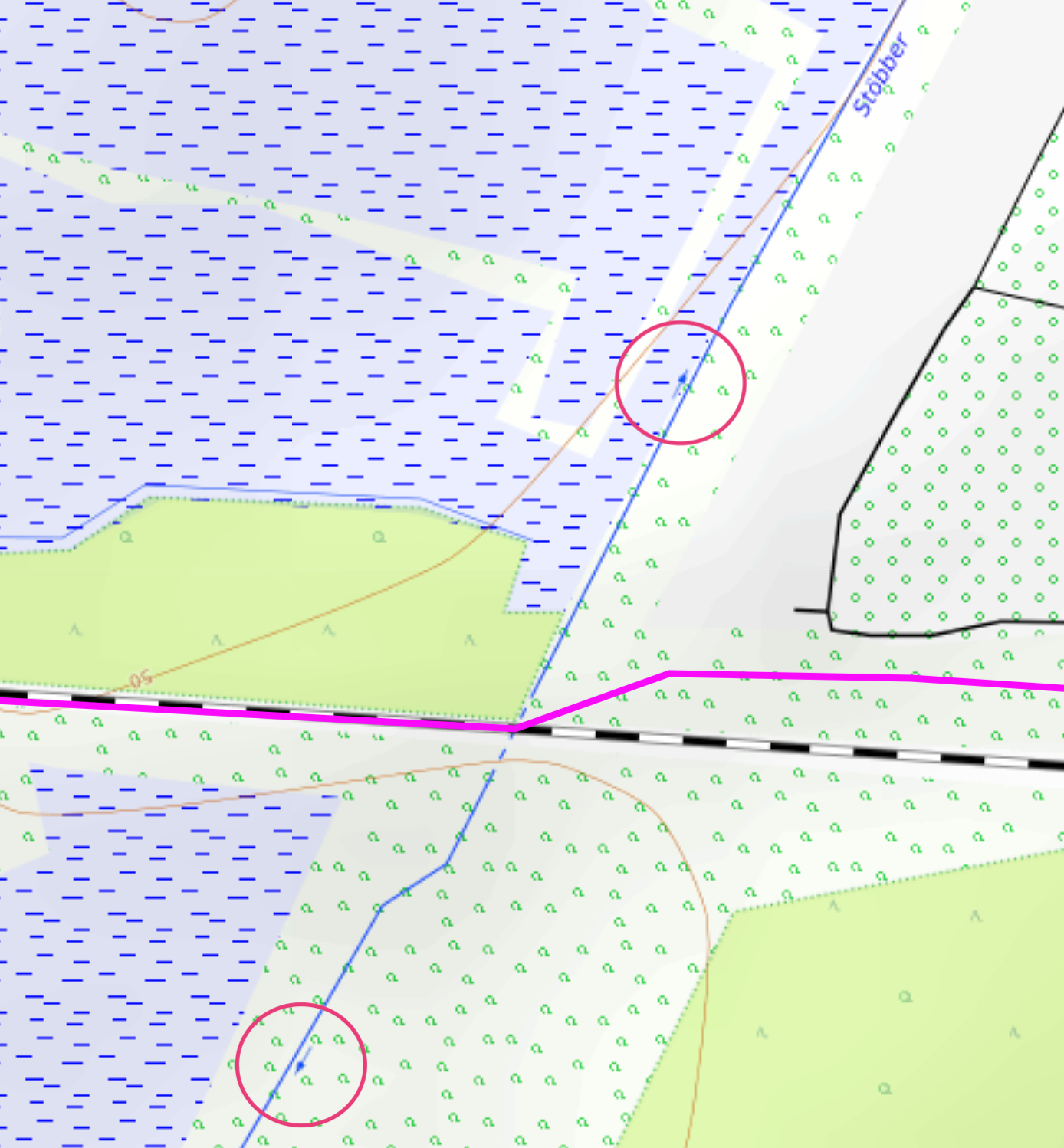
Topographical map of the Stöbber source, showing a change in the flow direction at the Baltic and North Sea continental divide
Summary
[edit]
| Description |
Deutsch: Topographische Karte der Stöbberquelle mit der Nordsee-Ostsee-Wasserscheide (rosa). Die markierten Pfeile zeigen die gegenteiligen Fließrichtungen des Flusses.
English: Topographical map of the Stöbber source, showing a change in the flow direction at the Baltic and North Sea continental divide |
| Date | |
| Source |
Background of the map is from opentopomap.org http://opentopomap.org/ With license at: https://creativecommons.org/licenses/by-sa/3.0/ The line of the continental divide is derived from the LFU Brandenburg, using the dataset ezg25.shp: http://www.lfu.brandenburg.de/ With license at: http://www.govdata.de/dl-de/by-2-0 The coloring of the continental divide and the circles are done by Sledbird |
| Author |
Sledbird Landesamt für Umwelt Brandenburg (LfU) OpenTopoMap (CC-BY-SA) |
Licensing
[edit]
| This image is in the public domain according to German copyright law because it is part of a statute, ordinance, official decree or judgment (official work) issued by a German authority or court (§ 5 Abs.1 UrhG).
|
 |
This file is licensed under the Creative Commons Attribution-Share Alike 3.0 Unported license.
- You are free:
- to share – to copy, distribute and transmit the work
- to remix – to adapt the work
- Under the following conditions:
- attribution – You must give appropriate credit, provide a link to the license, and indicate if changes were made. You may do so in any reasonable manner, but not in any way that suggests the licensor endorses you or your use.
- share alike – If you remix, transform, or build upon the material, you must distribute your contributions under the same or compatible license as the original.
File history
Click on a date/time to view the file as it appeared at that time.
| Date/Time | Thumbnail | Dimensions | User | Comment | |
|---|---|---|---|---|---|
| current | 16:20, 23 February 2021 | | 1,388 × 1,498 (634 KB) | Sledbird (talk | contribs) | Change of zoom level, content unchanged |
| 16:30, 20 February 2021 |  | 1,662 × 1,500 (859 KB) | Sledbird (talk | contribs) | Uploaded a work by Sledbird Landesamt für Umwelt Brandenburg (LfU) OpenTopoMap (CC-BY-SA) from Background of the map is from opentopomap.org http://opentopomap.org/ With license at: https://creativecommons.org/licenses/by-sa/3.0/ The line of the continental divide is derived from the LFU Brandenburg, using the dataset ezg25.shp: http://www.lfu.brandenburg.de/ With license at: http://www.govdata.de/dl-de/by-2-0 The coloring of the continental divide and the circles are done by Sledbird wit... |
You cannot overwrite this file.
File usage on Commons
There are no pages that use this file.
File usage on other wikis
The following other wikis use this file:
- Usage on de.wikipedia.org