File:St. Augustine- Part (Below Thirty Degrees Latitude) is on the Mainland of Florida, but the Sea Coast is More Low-Lying and thus Torn Away and Rendered Island-Like WDL202.png
Jump to navigation
Jump to search

Size of this preview: 782 × 600 pixels. Other resolutions: 313 × 240 pixels | 626 × 480 pixels | 1,001 × 768 pixels | 1,280 × 982 pixels | 1,335 × 1,024 pixels.
Original file (1,335 × 1,024 pixels, file size: 2.77 MB, MIME type: image/png)
Captions
Captions
Add a one-line explanation of what this file represents
Summary[edit]
_is_on_the_Mainland_of_Florida,_but_the_Sea_Coast_is_More_Low-Lying_and_thus_Torn_Away_and_Rendered_Island-Like_WDL202.png&action=edit§ion=1)
| Author |
Русский: Уайт, Джон (1585-1593)
Français : White, John (1585-1593)
English: White, John (1585-1593)
中文:怀特, 约翰 (1585-1593)
Português: White, John (1585-1593)
العربية: وايت, جون (1585-1593)
Español: White, John (1585-1593) |
| Title |
Русский: Сент- Августин: часть (ниже тридцати градусов северной широты) расположена в материковой зоне Флориды, а морское побережье находится ниже, поэтому оно оторвано и представлено в виде островов
Français : Ste. Augustine : zone (sous le 30ème degré de latitude) reliée à la Floride, mais la côte est plus basse et de ce fait ressemble à une île
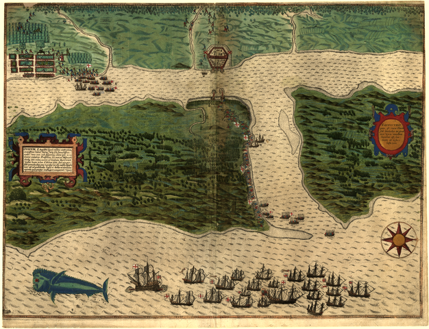
English: St. Augustine: Part (Below Thirty Degrees Latitude) is on the Mainland of Florida, but the Sea Coast is More Low-Lying and thus Torn Away and Rendered Island-Like
中文:圣 奥古斯汀:(纬度30度以下)部分为佛罗里达内陆,但海岸地势太低洼,因此陆地被毁,形成岛状地形
Português: Santo Agostinho: Parte (abaixo de trinta graus de latitude) está nas terras da Flórida, mas o litoral está mais abaixo e, por conseguinte, separado e mostrado como se fosse uma ilha
العربية: سانت أوغسطين : الجزء (الذي يقع تحت خط عرض ثلاثين درجة) الواقع على اليابسة في فلوريدا، ولكن ساحل البحر أكثر انخفاضا، مما جعله مشقوقا وشبيها بجزيرة.
Español: San Agustín: una parte (debajo de treinta grados de latitud) se encuentra en el sector continental de Florida, pero la costa del mar es más baja y, por tanto, separada y se la representa como una isla |
| Description |
Русский: Эта карта - самая ранняя гравюра, изображающая какую-либо точку на территории нынешних Соединенных Штатов. Также изображена рыба дорадо - один из объектов естественной истории, запечатленных Джоном Уайтом, губернатором первого англо-американдского поселения в Америке в регионе Хаттерас, входившем в то время в состав Вирджинии (ныне Северная Каролина). В ходе рейда сэра Фрэнсиса Дрейка на острова Вест-Индии в 1585-86 годах поселенцы Вирджинии были взяты на корабль и возвращены в Европу. Во время обратного путешествия составитель этого плана перерисовал рыбу с оригинала рисунка Уайта. На гравюре показана флотилья Дрейка, стоящая на якоре в устье реки Матанаса, часть войска, высаживающаяся на острове Анастасии и обстреливающае Форт Сан-Хуан-де-Пинос с другой стороны реки, и другая часть войска, высаживающаяся у жилого района на юге форта. Текст справа гласит, что дома были деревянными и располагались среди живописных садов, что гарнизон состоял из ста пятидесяти человек, причем еще большее количество солдат было в Форте св. Елены (Джексонвилл) к северу, и что эти гарнизоны были размещены здесь не потому, что территорию хотели захватить испанцы, а для того чтобы предотвратить вторжение англичан и французов.
Сражения; Колониальная Америка; Открытия и исследования; Дрейк, Фрэнсис, 1540?-1596 гг.; Крепости и фортификационные сооружения; Корабли; Солдаты; Испания–Колонии; Деревни Français : Cette carte est la première gravure représentant une ville ou un territoire des États-Unis d'aujourd'hui. Elle illustre une dorade, l'un des sujets d'histoire naturelle dessinés par John White, gouverneur de la première colonie anglo-américaine en Amérique, dans la région de Hatteras, qui faisait alors partie de la Virginie (maintenant la Caroline du Nord). Au cours de son invasion des Indes Occidentales, Sir Francis Drake rapatria les colons de Virginie en Europe. Durant le voyage retour, l'auteur de cette carte de vue put copier le poisson à partir d'un dessin original de White. La gravure montre la flotte de Drake ancrée au large de l'embouchure du fleuve Matanzas, un corps de troupes débarquant sur l'île Anastasia et bombardant le fort de San Juan de Pinos de l'autre côté du fleuve et un autre corps de troupes débarquant au sud du fort dans la partie résidentielle de la colonie. Le texte sur la gauche nous indique que les maisons étaient construites en bois et se trouvaient dans d'agréables jardins, que la garnison se composait de 150 hommes et autant à Fort Sainte- Hélène (Jacksonville) au nord ; ces garnisons se trouvaient là, non pas parce que les Espagnols voulaient le territoire, mais afin de contenir les Français et les Anglais.
Batailles; Amérique coloniale; Découverte et exploration; Drake, Francis, Sir, 1540 ?-1596; Forts et fortifications; Navires; Soldats; Espagne--Colonies; Villages English: This map is the earliest engraving of any city or territory now part of the United States. It also includes the dorado fish, one of the natural history subjects drawn by John White, governor of the first Anglo-American settlement in America, in the Hatteras region, then part of Virginia (now North Carolina). Sir Francis Drake’s 1585-86 raid on the West Indies picked up the Virginia settlers and returned them to Europe. In the course of the return voyage, the author of this view-plan was able to copy the figure of the fish from an original drawing by White. The engraving shows Drake’s fleet at anchor off the mouth of the Matanzas River, a body of troops landing on Anastasia Island and bombarding Fort San Juan de Pinos across the river, and another body of troops landing at the residential part of the settlement south of the fort. The text to the left tells us that the homes were built of wood and were situated among pleasant gardens, that the garrison consisted of 150 men, with as many more at Fort St. Helen (Jacksonville) to the north, and that these garrisons were placed there not because the Spaniards wanted the territory but so that they could keep out the English and French.
Battles; Colonial America; Discovery and exploration; Drake, Francis, Sir, 1540?-1596; Forts and fortifications; Ships; Soldiers; Spain--Colonies; Villages 中文:这幅地图是任何城市或今美国版图上的最早蚀刻板画。 地图上还包括剑鱼,它开始生活在在美国哈特拉斯地区,后来到了弗吉尼亚州的部分地区(今北卡罗莱纳州),它是首批英美移民长官约翰·怀特绘制的自然历史主题之一。 弗朗西斯·德雷克爵士1585-86 年间入侵西印度群岛时发现了维吉尼亚移民,并将他们带回了欧洲。 在返程过程中,本图片的作者复制了怀特原先创作的鱼图案。 蚀刻版画描述了停泊在马坦萨斯河口的德雷克舰队,一艘军舰登陆阿纳斯塔西娅岛,炮轰横跨河流的圣胡安皮诺斯堡垒,另一艘军舰在堡垒南边的移民居住地带登陆。 左边的文字告诉我们房屋用木材建造,坐落在舒适的花园中,驻军共150 人, 同时更多的人驻扎在北边的圣海伦(杰克逊维尔)堡垒。军队驻守在那里并非西班牙人想争夺这片土地,而是想将英国人与法国人赶出门外。
战役; 殖民地美洲; 发现与探索; 弗朗西斯·德雷克爵士,1540?-1596 年; 堡垒和防御工事; 船舶; 士兵; 西班牙-殖民地; 村庄 Português: Este mapa é a mais antiga gravura de qualquer cidade ou território hoje parte dos Estados Unidos. Também inclui o peixe dourado, uma das disciplinas de história natural criadas por John White, governador do primeiro assentamento anglo-americano na América, na região de Hatteras, então parte da Virgínia (agora Carolina do Norte). A incursão de Francis Drake em 1585-1586 às Índias Ocidentais, repatriou os colonos da Virgínia à Europa. No percurso da viagem de volta, o autor deste mapa pôde copiar a imagem do peixe a partir do desenho original de White. A gravura mostra a frota de Drake ancorando no largo da foz do Rio Matanzas, tropas desembarcado na Ilha de Anastasia e o bombardeo do Forte San Juan de Pinos do outro lado do rio, e outras tropas desembarcando na parte residencial do assentamento ao sul do forte. O texto à esquerda informa que as casas construídas eram de madeira situadas entre jardins agradáveis e que a tropa era composta de 150 homens, com tantas mais no Forte Sta. Helen (Jacksonville) para o norte, e que essas tropas foram colocadas lá não porque os espanhóis queriam o território mas para que pudessem manter de fora os ingleses e os franceses.
Batalhas; América Colonial; Descoberta e exploração; Drake, Francis, Sir, 1540?-1596; Fortes e fortificações; Navios; Soldados; Espanha - Colônias; Povoados العربية: تمثل هذه الخريطة نقشا أول نقشة لأي مدينة أو أرض تعد جزءا من الولايات المتحدة الآن. وهي تضم أيضا سمك الدورادو الذي يعد واحدا من مواضيع التاريخ الطبيعي التي رسمها جون وايت حاكم أول مستوطنة أنجلو أمريكية في أمريكا في منطقة هاتيراس، التي كانت آنذاك جزءا من فيرجينيا (حاليا كارولينا الشمالية). التقطت غارة السير فرانسيس دريك في 1585-86 على جزر الهند الغربية مستوطني فيرجينيا وأعادتهم إلى أوروبا. في أثناء رحلة العودة، تمكن مؤلف هذا المخطط من نسخ شكل السمكة من رسم أصلي بيد وايت. يظهر النقش أسطول دريك راسيا في منبع نهر ماتانزاس ومجموعة من الجنود تهبط على جزيرة اناستاسيا وتقصف قلعة سان جوان دي بينوس عبر النهر ومجموعة أخرى من الجنود تهبط في الجزء السكني من المستوطنة جنوبي القلعة. يخبرنا النص الموجود على اليسار أن البيوت كانت مبينة من الخشب وتقع بين حدائق بهيجة وأن الحامية العسكرية تشكلت من 150 رجلا وعدد أكبر في قلعة سانت
هيلين (جاكسونفيل) إلى الشمال وأن هذه الحاميات وضعت لإبقاء الإنجليز والفرنسيين بعيدا وليس لأن الأسبان أرادوا الأرض. المعارك; أمريكا المستعمرة; الاكتشاف والاستكشاف; دريك، فرانسيس، السير، 1540؟-1596; الحصون والتحصينات; السفن; الجنود; إسبانيا -- المستعمرات; القرى Español: Este mapa es el primer grabado de cualquier ciudad o territorio que ahora forma parte de los Estados Unidos. También incluye el dorado, uno de los temas de historia natural dibujado por John White, gobernador del primer asentamiento angloamericano en Estados Unidos, en la región de Hatteras, en ese momento parte del estado de Virginia (actualmente Carolina del Norte). La incursión de Sir Francis Drake de 1585-1586 en las Indias Occidentales tomó a los pobladores de Virginia y los regresó a Europa. En la travesía de retorno, el autor de este trabajo pudo copiar la figura del pez de un dibujo original de White. El grabado muestra la flota de Drake anclada en la desembocadura del río Matanzas, un cuerpo de tropas desembarcando en la isla Anastasia y bombardeando el Fuerte San Juan de Pinos al otro lado del río, y otro cuerpo de tropas aterrizando en la zona residencial del asentamiento sur de la fortaleza. El texto de la izquierda narra que las casas fueron construidas con madera y se encontraban entre los agradables jardines, que la guarnición estaba constituida por 150 hombres, con otros muchos más en el Fuerte Santa Elena (Jacksonville) al norte y que esas guarniciones se colocaron allí, no porque los españoles quisieran el territorio, sino para no dejar ingresar a los ingleses ni a los franceses.
Batallas; América Colonial; Descubrimiento y exploración; Drake, Francis, Sir, circa 1540-1596; Fuertes y fortificaciones; Buques; Soldados; España - Colonias; Aldeas |
| Date | 1589 |
| Medium |
Русский: Карты
Français : Cartes
English: Maps
中文:地图
Português: Mapas
العربية: خرائط
Español: Mapas |
| Dimensions |
English: 1 manuscript map : color ; 40 x 54 centimeters |
| Collection |
Русский: Библиотека Конгресса
Français : Bibliothèque du Congrès
English: Library of Congress
中文:国会图书馆
Português: Biblioteca do Congresso
العربية: مكتبة الكونغرس
Español: Biblioteca del Congreso |
| Current location |
Русский: Коллекция Ганса и Хэнни Краус, посвященная сэру Фрэнсису Дрейку
Français : Collection Sir Francis Drake de Hans et Hanni Kraus
English: Hans and Hanni Kraus Sir Francis Drake Collection
中文:汉斯和汉妮·克劳斯的弗朗西斯·德雷克爵士作品集
Português: Coleção Sir Francis Drake de Hans e Hanni Kraus
العربية: مجموعة السير فرانسس دريك لدى هانس وهاني كراوس
Español: Colección Sir Francis Drake de Hans y Hanni Kraus |
| Place of creation |
Русский: Сент-Августин
Français : Sainte Augustine
English: Saint Augustine
中文:圣奥古斯汀
Português: Santo Agostinho
العربية: سانت أوغسطين
Español: San Agustín |
| Notes | Original language title: S. Augustini : pars est terra Florida, sub latitudine 30 grad, ora vero maritima humilior est, lancinata et insulosa |
| References | http://hdl.loc.gov/loc.wdl/dlc.202 |
| Source/Photographer |
|
Licensing[edit]
_is_on_the_Mainland_of_Florida,_but_the_Sea_Coast_is_More_Low-Lying_and_thus_Torn_Away_and_Rendered_Island-Like_WDL202.png&action=edit§ion=2)
|
This is a faithful photographic reproduction of a two-dimensional, public domain work of art. The work of art itself is in the public domain for the following reason:
The official position taken by the Wikimedia Foundation is that "faithful reproductions of two-dimensional public domain works of art are public domain".
This photographic reproduction is therefore also considered to be in the public domain in the United States. In other jurisdictions, re-use of this content may be restricted; see Reuse of PD-Art photographs for details. | ||||
File history
Click on a date/time to view the file as it appeared at that time.
| Date/Time | Thumbnail | Dimensions | User | Comment | |
|---|---|---|---|---|---|
| current | 04:31, 11 March 2014 | | 1,335 × 1,024 (2.77 MB) | Fæ (talk | contribs) | =={{int:filedesc}}== {{Artwork |artist = |author ={{ru|1=Уайт, Джон (1585-1593)}} {{fr|1=White, John (1585-1593)}} {{en|1=White, John (1585-1593)}} {{zh|1=怀特, 约翰 (1585-1593)}} {{pt|1=White, John (1585-1593)}} {{ar|1=وايت, جون (15... |
You cannot overwrite this file.
File usage on Commons
The following 2 pages use this file:
_is_on_the_Mainland_of_Florida,_but_the_Sea_Coast_is_More_Low-Lying_and_thus_Torn_Away_and_Rendered_Island-Like_WDL202.png)
_is_on_the_Mainland_of_Florida,_but_the_Sea_Coast_is_More_Low-Lying_and_thus_Torn_Away_and_Rendered_Island-Like_WDL202.png&oldid=823947592)