File:Standard atlas of Washtenaw County, Michigan - including a plat book of the villages, cities and townships of the county, map of the state, United States and world, farmers directory, reference LOC 2007633240-32.jpg
Jump to navigation
Jump to search

Size of this preview: 701 × 600 pixels. Other resolutions: 280 × 240 pixels | 561 × 480 pixels | 897 × 768 pixels | 1,197 × 1,024 pixels | 2,393 × 2,048 pixels | 2,706 × 2,316 pixels.
Original file (2,706 × 2,316 pixels, file size: 1.12 MB, MIME type: image/jpeg)
Captions
Captions
Add a one-line explanation of what this file represents
Summary[edit]
| Description |
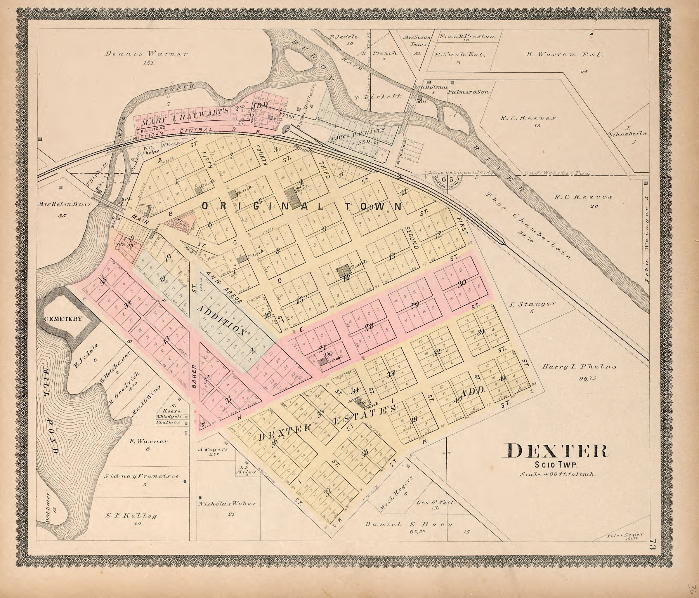
English: Available also through the Library of Congress Web site as a raster image. Includes index. Reparations around edges of title page and table of contents page. In manuscript on sheet pasted inside front cover: "Presented to Otto E. Haab by George Aprill, Scio, Mich., ... July 1922." Vendor: Mannings' Books & Prints Acquisitions control no. 2007-185 |
||
| Title | Standard atlas of Washtenaw County, Michigan : including a plat book of the villages, cities and townships of the county, map of the state, United States and world, farmers directory, reference business directory and departments devoted to general information, analysis of the system of U.S. land surveys, digest of the system of civil government, etc. etc. | ||
| Shelf ID | G1413.W2 G4 1895 | ||
| Parent | https://www.loc.gov/resource/g4113wm.gla00053/ | ||
| Sheet title | Dexter | ||
| Date | |||
| Source | https://www.loc.gov/item/2007633240/ | ||
| Author | Geo. A. Ogle & Co. | ||
| Permission (Reusing this file) |
|
||
| Other versions |
|
||
| Location | Washtenaw County · United States · Michigan | ||
| Part of | American Memory · Catalog · County Landownership Maps · Geography And Map Division · Cultural Landscapes | ||
| Subject | United States · Directories · Michigan · Washtenaw County · Maps · Real Property · Washtenaw County (Mich.) · Landowners |

Licensing[edit]
|
This is a faithful photographic reproduction of a two-dimensional, public domain work of art. The work of art itself is in the public domain for the following reason:
The official position taken by the Wikimedia Foundation is that "faithful reproductions of two-dimensional public domain works of art are public domain".
This photographic reproduction is therefore also considered to be in the public domain in the United States. In other jurisdictions, re-use of this content may be restricted; see Reuse of PD-Art photographs for details. | ||||
File history
Click on a date/time to view the file as it appeared at that time.
| Date/Time | Thumbnail | Dimensions | User | Comment | |
|---|---|---|---|---|---|
| current | 08:54, 11 July 2018 | | 2,706 × 2,316 (1.12 MB) | Fæ (talk | contribs) | LOC Maps multisheet https://www.loc.gov/item/2007633240/ sheet 32 of 53 #669 |
You cannot overwrite this file.
File usage on Commons
The following page uses this file: