File:Station Road level crossing, New Waltham - 1978 - geograph.org.uk - 7038596 (cropped).jpg
Jump to navigation
Jump to search

Size of this preview: 800 × 537 pixels. Other resolutions: 320 × 215 pixels | 640 × 430 pixels | 903 × 606 pixels.
Original file (903 × 606 pixels, file size: 196 KB, MIME type: image/jpeg)
Captions
Captions
Add a one-line explanation of what this file represents
Summary[edit]
| Description |
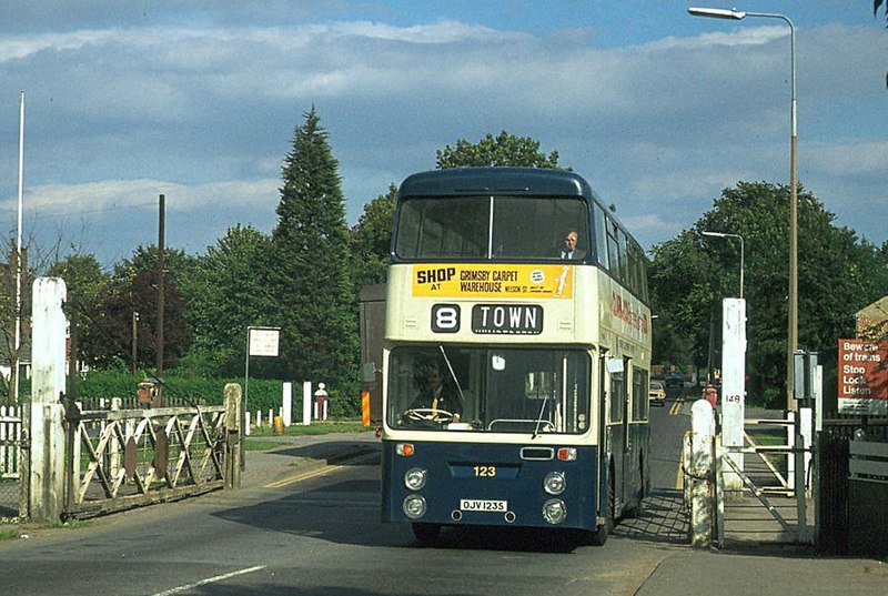
English: A fine set of traditional crossing gates, still in occasional use as the line remained open to freight traffic until 1980, despite passenger services having ceased in 1961.
The bus is no.123 of Grimsby-Cleethorpes Transport, an undertaking jointly owned by the Boroughs of Grimsby and Cleethorpes, which had merged their separate undertakings in 1957. It is a Leyland Fleetline with Roe bodywork, new in 1977. |
| Date | |
| Source |
This file was derived from: Station Road level crossing, New Waltham - 1978 - geograph.org.uk - 7038596.jpg |
| Author | Alan Murray-Rust |
| Other versions | |
| Attribution (required by the license) | Alan Murray-Rust / Station Road level crossing, New Waltham – 1978 / |

.jpg&action=edit§ion=1)
| Camera location | | View this and other nearby images on: OpenStreetMap |
|---|
.jpg¶ms=053.523567_N_-000.064109_E_globe:Earth_type:camera_heading:0.00&language=en)
Licensing[edit]
.jpg&action=edit§ion=2)
This file is licensed under the Creative Commons Attribution-Share Alike 2.0 Generic license.
Attribution: Alan Murray-Rust
- You are free:
- to share – to copy, distribute and transmit the work
- to remix – to adapt the work
- Under the following conditions:
- attribution – You must give appropriate credit, provide a link to the license, and indicate if changes were made. You may do so in any reasonable manner, but not in any way that suggests the licensor endorses you or your use.
- share alike – If you remix, transform, or build upon the material, you must distribute your contributions under the same or compatible license as the original.
File history
Click on a date/time to view the file as it appeared at that time.
| Date/Time | Thumbnail | Dimensions | User | Comment | |
|---|---|---|---|---|---|
| current | 22:16, 1 March 2023 | | 903 × 606 (196 KB) | Hullian111 (talk | contribs) | File:Station Road level crossing, New Waltham - 1978 - geograph.org.uk - 7038596.jpg cropped 29 % horizontally, 30 % vertically using CropTool with precise mode. |
You cannot overwrite this file.
File usage on Commons
The following 2 pages use this file:
File usage on other wikis
The following other wikis use this file:
- Usage on en.wikipedia.org
.jpg&oldid=829086408)