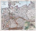
File:Stieler - Das Deutsche Reich in 4 Blättern, 1905 (composite map).jpg
From Wikimedia Commons, the free media repository
Jump to navigation
Jump to search

Size of this preview: 695 × 600 pixels. Other resolutions: 278 × 240 pixels | 556 × 480 pixels | 890 × 768 pixels | 1,187 × 1,024 pixels | 2,373 × 2,048 pixels | 10,459 × 9,026 pixels.
Original file (10,459 × 9,026 pixels, file size: 20.37 MB, MIME type: image/jpeg)
File information
Structured data
Captions
Captions
Add a one-line explanation of what this file represents
Summary
[edit]| DescriptionStieler - Das Deutsche Reich in 4 Blättern, 1905 (composite map).jpg |
English: German Reich, 1905 (Composite Map) / Das Deutsche Reich in 4 Blättern (1905). |
||||||||
| Date | 1905 | ||||||||
| Source | Stielers Hand-Atlas. 254 Haupt- und Nebenkarten in Kupferstich. Zehnte Auflage Hundertjahr - Ausgabe. Herausegeben unter Leitung von Prof. Dr. H. Haack, in Justus Perthes' Geogr. Anstalt. Gotha: Justus Perthes. >> (David Rumsey Historical Map Collection ). Original image resized and compressed before uploading. | ||||||||
| Author | Adolf Stieler (1775-1836). | ||||||||
| Permission (Reusing this file) |
|
||||||||
| Other versions |
|
||||||||
| Warning | The original file is very high-resolution. It might not load properly or could cause your browser to freeze when opened at full size. | Open in ZoomViewer |
|---|
File history
Click on a date/time to view the file as it appeared at that time.
| Date/Time | Thumbnail | Dimensions | User | Comment | |
|---|---|---|---|---|---|
| current | 20:58, 7 September 2018 |  | 10,459 × 9,026 (20.37 MB) | FDRMRZUSA (talk | contribs) | Reverted to lower resolution. |
| 16:00, 7 September 2018 |  | 13,241 × 11,361 (30.07 MB) | FDRMRZUSA (talk | contribs) | Higher resolution from same source. Corrected colors and light. | |
| 14:18, 7 September 2018 |  | 10,459 × 9,026 (20.37 MB) | FDRMRZUSA (talk | contribs) | User created page with UploadWizard |
You cannot overwrite this file.
File usage on Commons
The following 4 pages use this file:


