File:Straßenbrunnen02 Zehlendorf Riemeisterstraße ImGestell (4).jpg
Jump to navigation
Jump to search

Size of this preview: 800 × 600 pixels. Other resolutions: 320 × 240 pixels | 640 × 480 pixels | 1,024 × 768 pixels | 1,280 × 960 pixels | 2,560 × 1,920 pixels | 4,288 × 3,216 pixels.
Original file (4,288 × 3,216 pixels, file size: 6.08 MB, MIME type: image/jpeg)
Captions
Captions
Add a one-line explanation of what this file represents
Summary
[edit].jpg&action=edit§ion=1)
| Description |
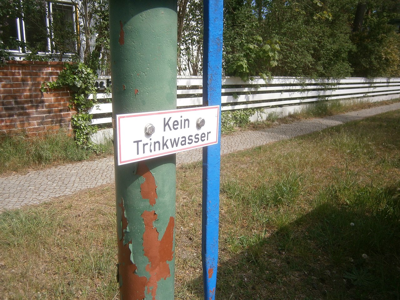
Deutsch: Der Brunnen (OSM-ID: 4973886434) steht an der Westseite von „Im Gestell“ südlich der Häuserzeile neben Riemeisterstraße 113. Der zylindrische Ständer besitzt einen blaulackierten Aufsatz zum Anschluss des Schwengels an den Hubkolben.[1] Der Standort befindet sich 250 Meter vom U-Bahnhof Onkel-Toms-Hütte. Der Schacht zum Sockelrohr ist mit zwei halben Eisenplatten abgedeckt, die im Rasenstreifen zwischen Gehweg und Bordstein liegen. Der Austritt steckt in einem am Ständer angeschweißten Rohr und am anderen Ende ist den Bogen mit dem Eimerhaken. Der Ablauf fällt auf eine Bodenfläche zwischen dem Rasen. Das Hinweisschild „Kein Trinkwasser“ ist vorhanden. Der Brunnen fördert nach einigen Hüben Wasser. Die Kappe am Kopf endet in einer pfeilartigen Spitze. |
| Date | |
| Source | Own work |
| Author | Boonekamp (d.i. Günter Haase) |
| Camera location | | View this and other nearby images on: OpenStreetMap |
|---|
.jpg¶ms=052.448372_N_0013.256713_E_globe:Earth_type:camera__&language=en)
Licensing
[edit].jpg&action=edit§ion=2)
I, the copyright holder of this work, hereby publish it under the following license:
This file is licensed under the Creative Commons Attribution-Share Alike 4.0 International license.
- You are free:
- to share – to copy, distribute and transmit the work
- to remix – to adapt the work
- Under the following conditions:
- attribution – You must give appropriate credit, provide a link to the license, and indicate if changes were made. You may do so in any reasonable manner, but not in any way that suggests the licensor endorses you or your use.
- share alike – If you remix, transform, or build upon the material, you must distribute your contributions under the same or compatible license as the original.
- ↑ vergleiche dazu die Bilder auf StreetView (Google Earth) aus dem Sommer 2008, unter Wahl der Adresse oder der Koordinaten.
File history
Click on a date/time to view the file as it appeared at that time.
| Date/Time | Thumbnail | Dimensions | User | Comment | |
|---|---|---|---|---|---|
| current | 16:01, 10 May 2020 | | 4,288 × 3,216 (6.08 MB) | Boonekamp (talk | contribs) | Uploaded own work with UploadWizard |
You cannot overwrite this file.
File usage on Commons
There are no pages that use this file.
.jpg&oldid=787054971)