File:Straßenbrunnen13 Wilhelmstadt Jägerstraße (3).jpg
Jump to navigation
Jump to search
Size of this preview: 450 × 600 pixels. Other resolutions: 180 × 240 pixels | 360 × 480 pixels | 576 × 768 pixels | 768 × 1,024 pixels | 1,536 × 2,048 pixels | 3,216 × 4,288 pixels.
Original file (3,216 × 4,288 pixels, file size: 6.07 MB, MIME type: image/jpeg)
Captions
Captions
Add a one-line explanation of what this file represents
Summary[edit]
.jpg&action=edit§ion=1)
| Description |
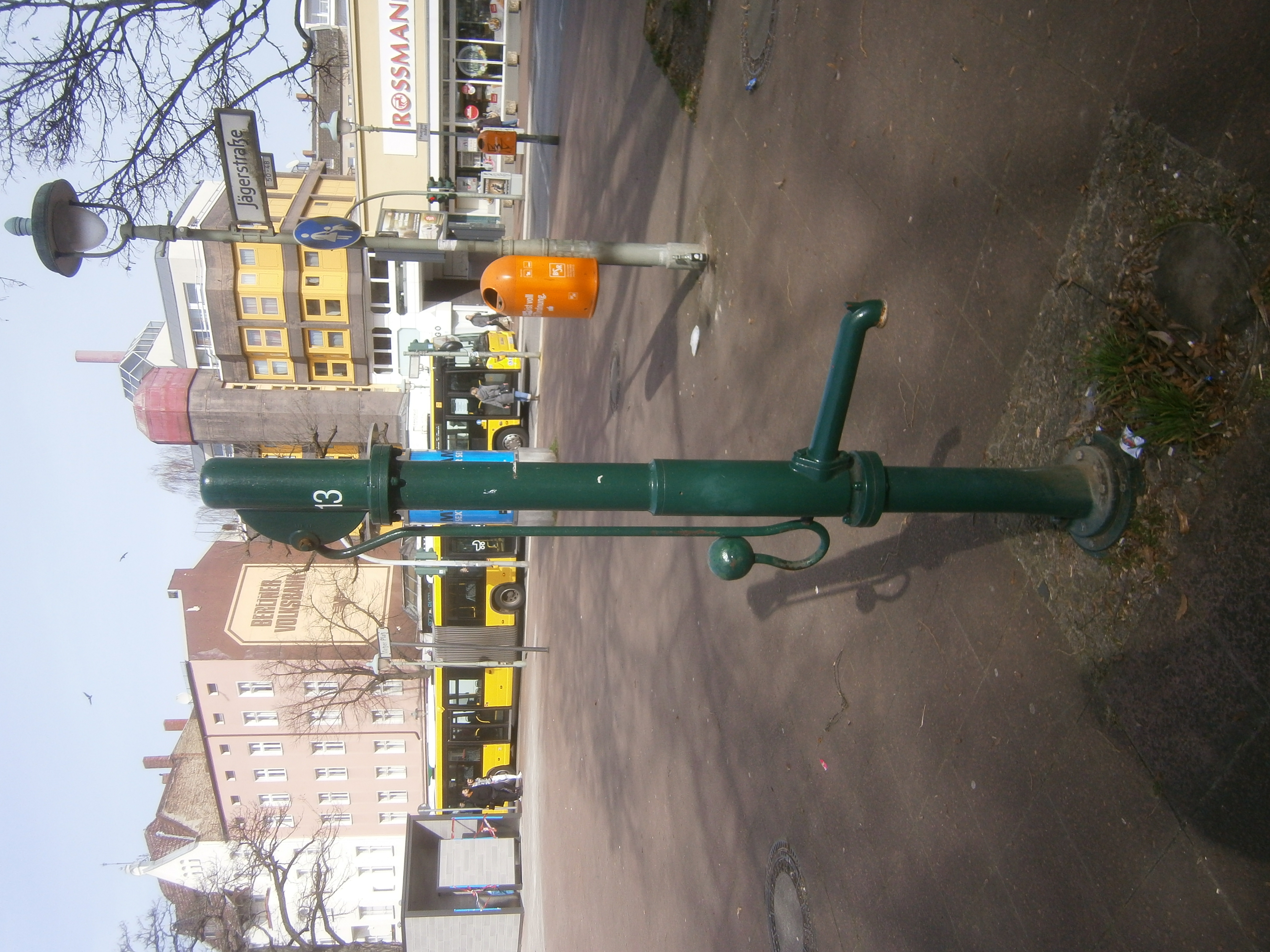
Deutsch: Der Brunnen 13 Spandaus steht im Süden des Metzer Platzes[1] östlich von der durch Poller begrenzten Überfahrt von der Metzer zur Jägerstraße (15 Meter zur Pichelsdorfer Straße). Dieser Brunnen mit der OSM-ID 6864424304[2] stand 2008 bei der Google-Aufnahme[3] noch nicht, ist 2014 jedoch erfasst. Der Brunnen steht auf einem Pflastermosaik, während der Platz mit Kunststeinplatten belegt ist. Zum Brunnen gehört der Straßeneinlass für den Ablauf, ein „Kein Trinkwasser“-Hinweis ist nicht zu erkennen, ein Blechschild oder die Bandschelle sind ebenfalls nicht vorhanden, der Brunnen ist intakt. |
| Date | |
| Source | Own work |
| Author | Boonekamp |
| Camera location | | View this and other nearby images on: OpenStreetMap |
|---|
.jpg¶ms=052.524960_N_0013.196847_E_globe:Earth_type:camera__&language=en)
Licensing[edit]
.jpg&action=edit§ion=2)
I, the copyright holder of this work, hereby publish it under the following license:
This file is licensed under the Creative Commons Attribution-Share Alike 4.0 International license.
- You are free:
- to share – to copy, distribute and transmit the work
- to remix – to adapt the work
- Under the following conditions:
- attribution – You must give appropriate credit, provide a link to the license, and indicate if changes were made. You may do so in any reasonable manner, but not in any way that suggests the licensor endorses you or your use.
- share alike – If you remix, transform, or build upon the material, you must distribute your contributions under the same or compatible license as the original.
- ↑ Straßenbefahrung 2014: Metzer Platz
- ↑ Details an Straßenbrunnen in Spandau: Metzer Platz
- ↑ Cite error: Invalid
<ref>tag; no text was provided for refs namedStreetView
File history
Click on a date/time to view the file as it appeared at that time.
| Date/Time | Thumbnail | Dimensions | User | Comment | |
|---|---|---|---|---|---|
| current | 10:27, 16 March 2020 | | 3,216 × 4,288 (6.07 MB) | Boonekamp (talk | contribs) | {{Information |description ={{de|1=Der Brunnen 13 Spandaus steht im Süden des Metzer Platzes<ref>[https://fbinter.stadt-berlin.de/fb/index.jsp?loginkey=zoomStart&mapId=k_StraDa@senstadt&bbox=377632,5820930,377709,5820976 Straßenbefahrung 2014: Metzer Platz]</ref> östlich von der durch Poller begrenzten Überfahrt von der Metzer zur Jägerstraße (15 Meter zur Pichelsdorfer Straße). Dieser Brunnen mit der OSM-ID 6864424304<ref>[https://www.openstreetmap.org/node/6864424304/history Details an St... |
You cannot overwrite this file.
File usage on Commons
The following 2 pages use this file:
.JPG&redirect=no)
File usage on other wikis
The following other wikis use this file:
- Usage on de.wikipedia.org
.jpg&oldid=845852943)