File:Straßenbrunnen144 FalkFeld Bramwaldweg (10).jpg
Jump to navigation
Jump to search
Size of this preview: 337 × 599 pixels. Other resolutions: 135 × 240 pixels | 270 × 480 pixels | 432 × 768 pixels | 576 × 1,024 pixels | 1,836 × 3,264 pixels.
Original file (1,836 × 3,264 pixels, file size: 1.88 MB, MIME type: image/jpeg)
Captions
Captions
Add a one-line explanation of what this file represents
Summary[edit]
.jpg&action=edit§ion=1)
| Description |
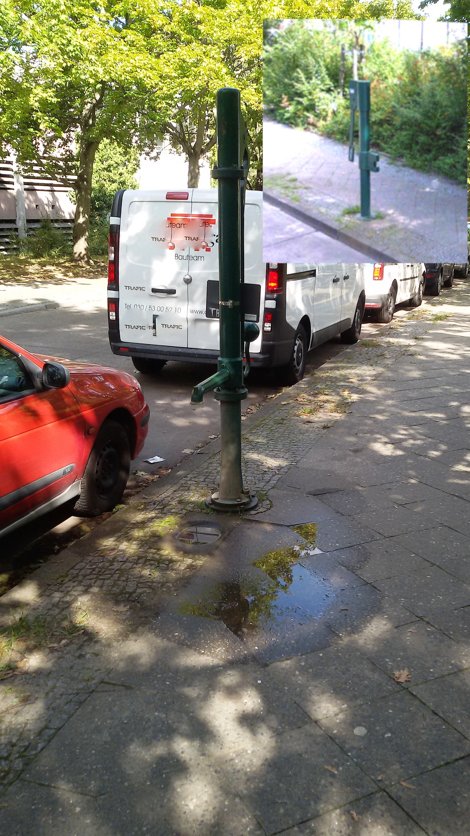
Deutsch: Der Straßenbrunnen steht auf dem östlichen Gehweg der Stichstraße 60 Meter südlich der Pionierstraße.[1] Der Brunnenfuß mit Frosthahn steht im gepflasterten Randstreifen mit einer Muldenplatte seitlich für den Wasserauffang, auf Grund der Neigung fließt das Wasser zunächst zum Gehweg. Der Schwengel und der Wasseraustritt, am Ansatzstück der kurzen Hülse der Säule stehen parallel zum Gehweg. Der Hinweis „Kein Trinkwasser“ ist auf dem rotumrandeden Blechschild in A4-Größe gegeben. 2008 stand noch ein grüner Schliephackebrunnen (wie im Bild oben rechts) in gleichem Stil an dieser Stelle, allerdings ohne das Schild "Kein Trinkwasser". Gegenüber vom Brunnen befindet sich das Parkhaus Nummer 4[2] und auf der Brunnenseite liegt ein Bolzplatz. Das umgebende Wohnkarree[3] von Westerwald- bis Zepplinstraße wurde in den 1970er Jahren erbaut. |
| Date | |
| Source | Own work |
| Author | Boonekamp (Günter Haase) |
| Camera location | | View this and other nearby images on: OpenStreetMap |
|---|
.jpg¶ms=052.551996_N_0013.181491_E_globe:Earth_type:camera__&language=en)
Licensing[edit]
.jpg&action=edit§ion=2)
I, the copyright holder of this work, hereby publish it under the following license:
This file is licensed under the Creative Commons Attribution-Share Alike 4.0 International license.
- You are free:
- to share – to copy, distribute and transmit the work
- to remix – to adapt the work
- Under the following conditions:
- attribution – You must give appropriate credit, provide a link to the license, and indicate if changes were made. You may do so in any reasonable manner, but not in any way that suggests the licensor endorses you or your use.
- share alike – If you remix, transform, or build upon the material, you must distribute your contributions under the same or compatible license as the original.
- ↑ Karte von Berlin: Bramwaldweg
- ↑ Marcel Eupen: Deutsche Wohnen erteilt Gutschriften im Falkenhagener Feld. In: Spandauer Volksblatt, 2. April 2019
- ↑ Gebäudealter der Wohnbebauung: Bramwald-/ Elmweg
File history
Click on a date/time to view the file as it appeared at that time.
| Date/Time | Thumbnail | Dimensions | User | Comment | |
|---|---|---|---|---|---|
| current | 09:35, 19 September 2019 | | 1,836 × 3,264 (1.88 MB) | Boonekamp (talk | contribs) | User created page with UploadWizard |
You cannot overwrite this file.
File usage on Commons
The following page uses this file:
File usage on other wikis
The following other wikis use this file:
- Usage on de.wikipedia.org
.jpg&oldid=616573431)