File:Straßenbrunnen146 Staaken Isenburger Weg (1).jpg
Jump to navigation
Jump to search

Size of this preview: 502 × 599 pixels. Other resolutions: 201 × 240 pixels | 402 × 480 pixels | 643 × 768 pixels | 858 × 1,024 pixels | 1,716 × 2,048 pixels | 3,174 × 3,789 pixels.
Original file (3,174 × 3,789 pixels, file size: 2.63 MB, MIME type: image/jpeg)
Captions
Captions
Add a one-line explanation of what this file represents
Summary[edit]
.jpg&action=edit§ion=1)
| Description |
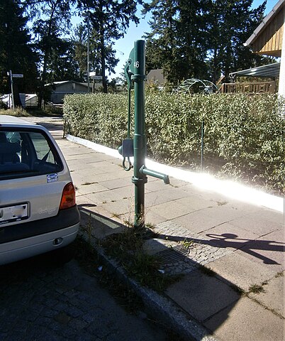
Deutsch: Der Brunnen steht auf einem Pflasterkarree vor der Stirnseite des Siedlungshauses auf dem Eckgrundstück Ferbitzer/Isenburger Weg.[1][2] Am Brunnenfuß befindet sich innerhalb der Pflasterung der Straßeneinlass. Über diesem endet der Rohrbogen des Austritts, der an einer langen Hülse geflanscht ebenso wie der Schwengel parallel zum Bordstein liegt. An der Schwengelseite besagt die Blechtafel „kein Trinkwasser“. Der Brunnen steht auf dem Sockelrohr mittig zwischen Hauszufahrt 65 und Straßenecke. 80 Meter südlich vom Brunnen kreuzt der Heidelakengraben den Isenburger Weg. Bis zum Austausch des Notwasserbrunnens (spätestens) 2012 stand ein gelber Schliephacke-Brunnen auf einem Kleinpflastermosaik am Bordstein neben der Grundstückseinfahrt zu Haus 65 ebenfalls mit Austritt und Schwengel parallel zum Gehweg. Dieser Standort lag 30 Meter von der Straßenecke, der neue Standort 15 Meter von der Straßenecke. Die Wohnhäuser an der Straßenecke wurden um 2005 erbaut. Die Umgebung des Brunnenstandortes gehörte bis 1990 zu West-Staaken und damit 500 Meter von der Mauer auf DDR-/Brandenburger Gebiet. Der vorherige Schliephacke war entsprechend erst in den 1990er Jahren im Bezirk Spandau aufgestellt worden. |
| Date | |
| Source | Own work |
| Author | Boonekamp (Günter Haaase) |
| Camera location | | View this and other nearby images on: OpenStreetMap |
|---|
.jpg¶ms=052.545402_N_0013.136436_E_globe:Earth_type:camera__&language=en)
Licensing[edit]
.jpg&action=edit§ion=2)
I, the copyright holder of this work, hereby publish it under the following license:
This file is licensed under the Creative Commons Attribution-Share Alike 4.0 International license.
- You are free:
- to share – to copy, distribute and transmit the work
- to remix – to adapt the work
- Under the following conditions:
- attribution – You must give appropriate credit, provide a link to the license, and indicate if changes were made. You may do so in any reasonable manner, but not in any way that suggests the licensor endorses you or your use.
- share alike – If you remix, transform, or build upon the material, you must distribute your contributions under the same or compatible license as the original.
File history
Click on a date/time to view the file as it appeared at that time.
| Date/Time | Thumbnail | Dimensions | User | Comment | |
|---|---|---|---|---|---|
| current | 16:19, 13 October 2019 | | 3,174 × 3,789 (2.63 MB) | Boonekamp (talk | contribs) | User created page with UploadWizard |
You cannot overwrite this file.
File usage on Commons
The following page uses this file:
File usage on other wikis
The following other wikis use this file:
- Usage on de.wikipedia.org
.jpg&oldid=506244594)