File:Straßenbrunnen147 Staaken Fachinger Weg (1).jpg
Jump to navigation
Jump to search

Size of this preview: 449 × 599 pixels. Other resolutions: 180 × 240 pixels | 360 × 480 pixels | 576 × 768 pixels | 768 × 1,024 pixels | 1,536 × 2,048 pixels | 3,143 × 4,191 pixels.
Original file (3,143 × 4,191 pixels, file size: 3.75 MB, MIME type: image/jpeg)
Captions
Captions
Add a one-line explanation of what this file represents
Summary[edit]
.jpg&action=edit§ion=1)
| Description |
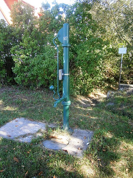
Deutsch: Der Brunnen steht in der Ortslage Neustaaken (vormals Eigenhimsiedlung Staaken) auf dem Grünstreifen zwischen Fahrbahn und Grundstücksgrenze neben der Grundstückszufahrt. Der Standort liegt an der östlichen Straßenseite zwischen Aumetzer (100 m südlich) und Ferbitzer Weg (70 Meter nördlich). Südlich am Brunnen kreuzt die Straße den Heidelakegraben mit einem Brückenbauwerk in Form der Durchrohrung des Straßenraums. Der FSH-Brunnenständer steht neben dem Straßeneinlauf auf einer Betonplatte (die mindestens seit 2012 liegt) neben dem Pfad zum Grabenlauf. Der Austritt an einer langen Hülse an der Brunnensäule ist zur Fahrbahn grichtet, der Schwengel steht quer dazu. Der Hinweis zum Trinkwasser ist auf einem Blechschild unter dem Schwengel aufgesetzt. 2008 (1992-2012) stand an gleicher Stelle ein grüner Schliephacke-Brunnen mit Schwengel und Austritt parallel zur Fahrbahn. Da der Standort bis 1990 zu West-Staaken (Gemeinde Staaken im Kreis Nauen) gehörte und dadurch außerhalb vom Bezirk Spandau[1] lag wurde der Schliephacke frühestens Anfang der 1990er Jahre aufgestellt. |
| Date | |
| Source | Own work |
| Author | Boonekamp (Günter Haaase) |
| Camera location | | View this and other nearby images on: OpenStreetMap |
|---|
.jpg¶ms=052.544103_N_0013.129327_E_globe:Earth_type:camera__&language=en)
Licensing[edit]
.jpg&action=edit§ion=2)
I, the copyright holder of this work, hereby publish it under the following license:
This file is licensed under the Creative Commons Attribution-Share Alike 4.0 International license.
- You are free:
- to share – to copy, distribute and transmit the work
- to remix – to adapt the work
- Under the following conditions:
- attribution – You must give appropriate credit, provide a link to the license, and indicate if changes were made. You may do so in any reasonable manner, but not in any way that suggests the licensor endorses you or your use.
- share alike – If you remix, transform, or build upon the material, you must distribute your contributions under the same or compatible license as the original.
File history
Click on a date/time to view the file as it appeared at that time.
| Date/Time | Thumbnail | Dimensions | User | Comment | |
|---|---|---|---|---|---|
| current | 10:49, 14 October 2019 | | 3,143 × 4,191 (3.75 MB) | Boonekamp (talk | contribs) | User created page with UploadWizard |
You cannot overwrite this file.
File usage on Commons
The following page uses this file:
File usage on other wikis
The following other wikis use this file:
- Usage on de.wikipedia.org
.jpg&oldid=502551384)