File:Straßenbrunnen 31 FalkenhFeld Recklinghauser Weg (2).jpg
Jump to navigation
Jump to search

Size of this preview: 450 × 600 pixels. Other resolutions: 180 × 240 pixels | 360 × 480 pixels | 576 × 768 pixels | 768 × 1,024 pixels | 1,536 × 2,048 pixels | 3,135 × 4,179 pixels.
Original file (3,135 × 4,179 pixels, file size: 3.15 MB, MIME type: image/jpeg)
Captions
Captions
Add a one-line explanation of what this file represents
Summary[edit]
.jpg&action=edit§ion=1)
| Description |
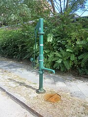
Deutsch: Im Juli 2008 stand noch ein gelber Schliephacke gegenüber vom Siedlungshaus 23 auf dem östlichen Gehsteig. Der Brunnenkörper wurde 2012 durch eine FSH-Säule mit langer Hülse für den Wasseraustritt ersetzt. Zudem existiert für den Brunnen nunmehr ein gesonderter Straßeneinlass. Auf der Brunnenseite der Straße befindet sich das Schulgrundstück der Bernhard-Traven-Schule[1] und Siegerland-Schule[2][3] Vom Brunnenstandort sind es nach Süden 50 Meter zur Portaer Straße, 135 Meter zur Gelsenkirchener Straße und 250 Meter zum Spekteweg, nach Norden 140 Meter zur Iserlohner Straße. Der Brunnen steht direkt vor einem Zugang zum Schulhof zwischen Schulgebäude 24a und 26. |
| Date | |
| Source | Own work |
| Author | Boonekamp - mithin Günter Haase |
| Camera location | | View this and other nearby images on: OpenStreetMap |
|---|
.jpg¶ms=052.546127_N_0013.173345_E_globe:Earth_type:camera__&language=en)
Licensing[edit]
.jpg&action=edit§ion=2)
I, the copyright holder of this work, hereby publish it under the following license:
This file is licensed under the Creative Commons Attribution-Share Alike 4.0 International license.
- You are free:
- to share – to copy, distribute and transmit the work
- to remix – to adapt the work
- Under the following conditions:
- attribution – You must give appropriate credit, provide a link to the license, and indicate if changes were made. You may do so in any reasonable manner, but not in any way that suggests the licensor endorses you or your use.
- share alike – If you remix, transform, or build upon the material, you must distribute your contributions under the same or compatible license as the original.
- ↑ Recklinghauser Weg 26, 13583 Berlin, Die B.-Traven-Gemeinschaftsschule – BTG – ist seit 2018 regulär eine Gemeinschaftsschule
- ↑ Westerwaldstraße 19-21, 13589 Berlin, Die Schule: Erbaut 1965 im Neubaugebiet „Falkenhagener Feld“
- ↑ Karte von Berlin: Siegerlandviertel
File history
Click on a date/time to view the file as it appeared at that time.
| Date/Time | Thumbnail | Dimensions | User | Comment | |
|---|---|---|---|---|---|
| current | 14:36, 21 August 2019 | | 3,135 × 4,179 (3.15 MB) | Boonekamp (talk | contribs) | User created page with UploadWizard |
You cannot overwrite this file.
File usage on Commons
The following page uses this file:
File usage on other wikis
The following other wikis use this file:
- Usage on de.wikipedia.org
.jpg&oldid=499819127)