File:Straßenbrunnen 41 Haselhorst Simonring (4).jpg
Jump to navigation
Jump to search

Size of this preview: 449 × 599 pixels. Other resolutions: 180 × 240 pixels | 360 × 480 pixels | 576 × 768 pixels | 768 × 1,024 pixels | 1,536 × 2,048 pixels | 3,143 × 4,191 pixels.
Original file (3,143 × 4,191 pixels, file size: 2.47 MB, MIME type: image/jpeg)
Captions
Captions
Add a one-line explanation of what this file represents
Summary[edit]
.jpg&action=edit§ion=1)
| Description |
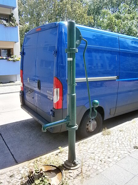
Deutsch: 2008 stand eine gelbe Schliephackepumpe der 1960er Jahre[1] im Simonring 40 Meter vom Faucherweg am westlichen Gehsteigrand. Innerhalb der 2010er Jahre wurde sie durch eine dreiteilige Säule einer FSH-L-Pumpe ersetzt. Der Standort befindet sich zwischen dem Hauszugang des viergeschossigen Wohnhauses 12 und dem des Hauses 14. Der Brunnenkörper mit dem Schwengel und dem gegenüberliegenden Austrittsrohr steht im Kleinpflaster des Gehwegrandes. Unter dem Rohrbogen des Wasseraustritts liegt neben dem Brunnenfuß der Straßeneinlass. Die Entfernung zur nächstgelegenen Zapfstelle im Faucherweg beträgt weniger als 300 Meter. Die Wohnbebauung der Siedlung zwischen Gartenfelder Straße und Nonnendammallee[2] wurde in den 1950er Jahren auf dem Gelände der Haselhorster Kleingartensiedlung „Hoffnung-Nord“[3] errichtet. |
| Date | |
| Source | Own work |
| Author | Boonekamp (G. Haase) |
| Camera location | | View this and other nearby images on: OpenStreetMap |
|---|
.jpg¶ms=052.541263_N_0013.239092_E_globe:Earth_type:camera__&language=en)
Licensing[edit]
.jpg&action=edit§ion=2)
I, the copyright holder of this work, hereby publish it under the following license:
This file is licensed under the Creative Commons Attribution-Share Alike 4.0 International license.
- You are free:
- to share – to copy, distribute and transmit the work
- to remix – to adapt the work
- Under the following conditions:
- attribution – You must give appropriate credit, provide a link to the license, and indicate if changes were made. You may do so in any reasonable manner, but not in any way that suggests the licensor endorses you or your use.
- share alike – If you remix, transform, or build upon the material, you must distribute your contributions under the same or compatible license as the original.
- ↑ Cite error: Invalid
<ref>tag; no text was provided for refs namedStreetView - ↑ Karte von Berlin: zwischen Gartenfelder Straße und Nonnendammallee
- ↑ Ein östlicher Rest der KGA Hoffnung existiert noch zwischen dem Schulkomplex (Oberstufenzentrum) und der Ortsvermittlungsstelle neben dem Gorgasring.
File history
Click on a date/time to view the file as it appeared at that time.
| Date/Time | Thumbnail | Dimensions | User | Comment | |
|---|---|---|---|---|---|
| current | 14:56, 15 July 2019 | | 3,143 × 4,191 (2.47 MB) | Boonekamp (talk | contribs) | User created page with UploadWizard |
You cannot overwrite this file.
File usage on Commons
The following page uses this file:
File usage on other wikis
The following other wikis use this file:
- Usage on de.wikipedia.org
.jpg&oldid=506838288)