File:Strait of Hormuz (MODIS 2020-12-04).jpg
Jump to navigation
Jump to search

Size of this preview: 770 × 600 pixels. Other resolutions: 308 × 240 pixels | 616 × 480 pixels | 986 × 768 pixels | 1,280 × 997 pixels | 2,235 × 1,741 pixels.
Original file (2,235 × 1,741 pixels, file size: 353 KB, MIME type: image/jpeg)
Captions
Captions
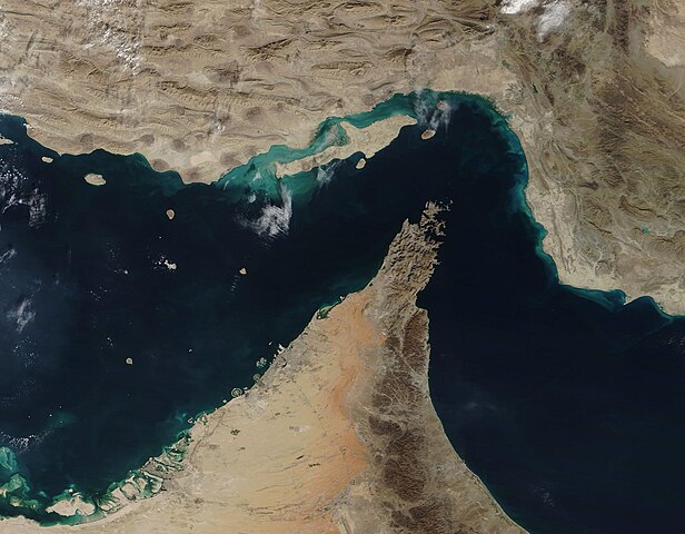
On December 2, 2020, the Moderate Resolution Imaging Spectroradiometer (MODIS) on board NASA’s Terra satellite acquired a true-color image of the Strait of Hormuz.
Summary
[edit].jpg&action=edit§ion=1)
| Description |
English: The narrow Strait of Hormuz lies between the Persian Gulf and the Gulf of Oman, separating Iran (north) from the Arabian Peninsula (south). Only about 21 miles (34 km) wide at the narrowest point and roughly 96 miles (155 km) long, about thirty percent of the world’s seaborne oil and nearly one-quarter of the liquified natural gas (LNG) supply passes through this strait — all on shipping lanes that measure only two-mile wide. It has been estimated that 21 million barrels of oil, with a value of 1.2 billion US dollars (USD), pass through the strait every day.
On December 2, 2020, the Moderate Resolution Imaging Spectroradiometer (MODIS) on board NASA’s Terra satellite acquired a true-color image of the Strait of Hormuz. The arid landscape of Iran sits in the north, with Qeshm Island, the largest in the Persian Gulf, just off the Iranian coast. The tiny Strait of Khuran separates the island and the mainland and bounds a wetland of international importance, recognized by Ramsar. These wetlands provide critical habitat to two globally threatened species: the Dalmatian Pelican and the Green sea turtle. In the south, the rocky and rugged Musandam Peninsula juts into the Strait of Hormuz. The tip of the peninsula is filled by the Musandam Governate, an exclave of Oman. To the south, the land on the peninsula belongs to the United Arab Emirates. |
||
| Date | Taken on 2 December 2020 | ||
| Source |
Strait of Hormuz (direct link)
|
||
| Author | MODIS Land Rapid Response Team, NASA GSFC |
| This media is a product of the Terra mission Credit and attribution belongs to the mission team, if not already specified in the "author" row |
Licensing
[edit].jpg&action=edit§ion=2)
| This file is in the public domain in the United States because it was solely created by NASA. NASA copyright policy states that "NASA material is not protected by copyright unless noted". (See Template:PD-USGov, NASA copyright policy page or JPL Image Use Policy.) | ||
 |
Warnings:
|
File history
Click on a date/time to view the file as it appeared at that time.
| Date/Time | Thumbnail | Dimensions | User | Comment | |
|---|---|---|---|---|---|
| current | 19:24, 2 February 2024 | | 2,235 × 1,741 (353 KB) | OptimusPrimeBot (talk | contribs) | #Spacemedia - Upload of http://modis.gsfc.nasa.gov/gallery/images/image12042020_250m.jpg via Commons:Spacemedia |
You cannot overwrite this file.
File usage on Commons
There are no pages that use this file.
.jpg&oldid=848354616)