File:Strait of Hormuz and Musandam Peninsula (MODIS 2018-12-10).jpg
Jump to navigation
Jump to search

Size of this preview: 748 × 600 pixels. Other resolutions: 299 × 240 pixels | 599 × 480 pixels | 958 × 768 pixels | 1,277 × 1,024 pixels | 2,320 × 1,860 pixels.
Original file (2,320 × 1,860 pixels, file size: 453 KB, MIME type: image/jpeg)
Captions
Captions
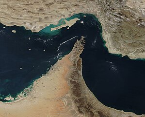
The Moderate Resolution Imaging Spectroradiometer (MODIS) on board NASA’s Terra satellite acquired a stunning true-color image of the Strait of Hormuz and the Musandam Peninsula on December 6, 2018.
Summary
[edit].jpg&action=edit§ion=1)
| Description |
English: The rugged, barren mountains of the Musandam Peninsula juts into the Strait of Hormuz, the narrow throughway between Iran (north) and Oman and the United Arab Emirates (south) where the waters from the Gulf of Oman enter the Persian Gulf. Khasab, Oman, the main city sitting on the tip of the Musandam Peninsula, sits only 65 km (40 mi) from the Iranian city of Bandar Abbas. The rocky limestone mountains of the peninsula rise as high as 6,500 feet (2,000 meters) above sea level and create fjord-like inlets along the coast. Musandam is an exclave of Oman, separated from the rest of the country by the United Arab Emirates. Fishing, agriculture and ship building are the primary industries in this part of Oman.
The Moderate Resolution Imaging Spectroradiometer (MODIS) on board NASA’s Terra satellite acquired a stunning true-color image of the Strait of Hormuz and the Musandam Peninsula on December 6, 2018. |
||
| Date | Taken on 6 December 2018 | ||
| Source |
Strait of Hormuz and Musandam Peninsula (direct link)
|
||
| Author | MODIS Land Rapid Response Team, NASA GSFC |
| This media is a product of the Terra mission Credit and attribution belongs to the mission team, if not already specified in the "author" row |
Licensing
[edit].jpg&action=edit§ion=2)
| This file is in the public domain in the United States because it was solely created by NASA. NASA copyright policy states that "NASA material is not protected by copyright unless noted". (See Template:PD-USGov, NASA copyright policy page or JPL Image Use Policy.) | ||
 |
Warnings:
|
File history
Click on a date/time to view the file as it appeared at that time.
| Date/Time | Thumbnail | Dimensions | User | Comment | |
|---|---|---|---|---|---|
| current | 01:20, 17 February 2024 | | 2,320 × 1,860 (453 KB) | OptimusPrimeBot (talk | contribs) | #Spacemedia - Upload of http://modis.gsfc.nasa.gov/gallery/images/image12102018_250m.jpg via Commons:Spacemedia |
You cannot overwrite this file.
File usage on Commons
There are no pages that use this file.
.jpg&oldid=852528587)