File:Straßenbahnnetz Wien.png
Jump to navigation
Jump to search

Size of this preview: 600 × 600 pixels. Other resolutions: 240 × 240 pixels | 480 × 480 pixels | 768 × 768 pixels | 1,024 × 1,024 pixels | 2,048 × 2,048 pixels | 4,154 × 4,154 pixels.
Original file (4,154 × 4,154 pixels, file size: 2.85 MB, MIME type: image/png)
Captions
Captions
Add a one-line explanation of what this file represents
Summary[edit]
| Description |
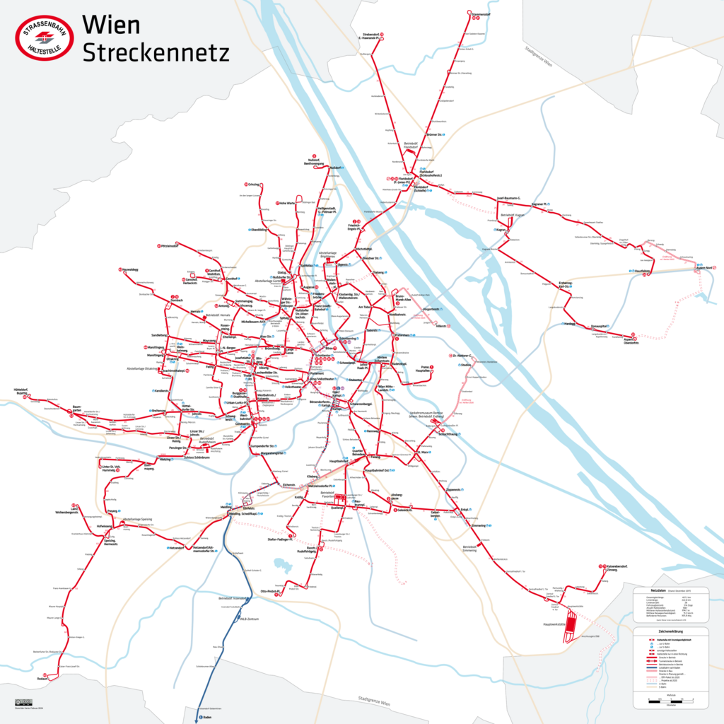
English: Vienna streetcar network
Deutsch: Netzplan der Straßenbahn Wien
Français : Réseau des tramways de Vienne |
| Date | |
| Source | Own work |
| Author | HerrMay |
Licensing[edit]
I, the copyright holder of this work, hereby publish it under the following license:
This file is licensed under the Creative Commons Attribution-Share Alike 3.0 Unported license.
- You are free:
- to share – to copy, distribute and transmit the work
- to remix – to adapt the work
- Under the following conditions:
- attribution – You must give appropriate credit, provide a link to the license, and indicate if changes were made. You may do so in any reasonable manner, but not in any way that suggests the licensor endorses you or your use.
- share alike – If you remix, transform, or build upon the material, you must distribute your contributions under the same or compatible license as the original.
File history
Click on a date/time to view the file as it appeared at that time.
| Date/Time | Thumbnail | Dimensions | User | Comment | |
|---|---|---|---|---|---|
| current | 08:44, 15 February 2024 | | 4,154 × 4,154 (2.85 MB) | HerrMay (talk | contribs) | aktualisiert |
| 22:58, 9 November 2020 |  | 4,154 × 4,154 (2.76 MB) | HerrMay (talk | contribs) | Station Nordbahnstraße angepasst | |
| 16:43, 9 November 2020 |  | 4,154 × 4,154 (2.76 MB) | HerrMay (talk | contribs) | Design der Aktualisierungen angepasst | |
| 09:14, 24 October 2020 |  | 4,154 × 4,154 (2.71 MB) | Stefan8410 (talk | contribs) | 25er Seestadt Aspern auch strichliert eingezeichnet da nicht mehr 2020 | |
| 10:36, 12 October 2020 |  | 4,154 × 4,154 (2.57 MB) | Linie29 (talk | contribs) | Neue Haltestellen am 42er; diverse Kleinigkeiten | |
| 14:33, 6 October 2020 |  | 4,154 × 4,154 (2.57 MB) | Linie29 (talk | contribs) | Streckenabschnitt Kagran - Kagraner Platz entfernt | |
| 09:48, 5 October 2020 |  | 4,154 × 4,154 (2.58 MB) | Linie29 (talk | contribs) | O-Wagen Verlängerung ergänzt | |
| 01:42, 19 January 2020 |  | 4,154 × 4,154 (2.76 MB) | HerrMay (talk | contribs) | Haltestelle ''Geiereckstraße'' angepasst | |
| 01:29, 19 January 2020 |  | 4,154 × 4,154 (2.77 MB) | HerrMay (talk | contribs) | aktualisiert | |
| 21:15, 16 November 2019 |  | 4,153 × 4,153 (2.59 MB) | Linie29 (talk | contribs) | 71 und WLB aktualisiert |
You cannot overwrite this file.
File usage on Commons
The following 21 pages use this file:
- User:Chumwa/OgreBot/Potential transport maps/2017 November 21-30
- User:Chumwa/OgreBot/Potential transport maps/2019 November 11-20
- User:Chumwa/OgreBot/Potential transport maps/2020 January 11-20
- User:Chumwa/OgreBot/Public transport information/2017 November 21-30
- User:Chumwa/OgreBot/Public transport information/2019 November 11-20
- User:Chumwa/OgreBot/Public transport information/2020 January 11-20
- User:Chumwa/OgreBot/Public transport information/2020 November 1-10
- User:Chumwa/OgreBot/Public transport information/2020 October 1-10
- User:Chumwa/OgreBot/Public transport information/2020 October 11-20
- User:Chumwa/OgreBot/Public transport information/2020 October 21-31
- User:Chumwa/OgreBot/Public transport information/2024 February 10-19
- User:Chumwa/OgreBot/Transport Maps/2017 November 21-30
- User:Chumwa/OgreBot/Transport Maps/2019 November 11-20
- User:Chumwa/OgreBot/Transport Maps/2020 January 11-20
- User:Chumwa/OgreBot/Transport Maps/2020 November 1-10
- User:Chumwa/OgreBot/Transport Maps/2020 October 1-10
- User:Chumwa/OgreBot/Transport Maps/2020 October 11-20
- User:Chumwa/OgreBot/Transport Maps/2020 October 21-31
- User:Chumwa/OgreBot/Transport Maps/2024 February 10-19
- User:Chumwa/OgreBot/Travel and communication maps/2017 November 21-30
- User:HerrMay
File usage on other wikis
The following other wikis use this file:
- Usage on az.wikipedia.org
- Usage on be-tarask.wikipedia.org
- Usage on be.wikipedia.org
- Usage on cs.wikipedia.org
- Usage on da.wikipedia.org
- Usage on de.wikipedia.org
- Usage on en.wikipedia.org
- Usage on eo.wikipedia.org
- Usage on fa.wikipedia.org
- Usage on hu.wikipedia.org
- Usage on hy.wikipedia.org
- Usage on id.wikipedia.org
- Usage on it.wikipedia.org
- Usage on ja.wikipedia.org
- Usage on nl.wikipedia.org
- Usage on pl.wikipedia.org
- Usage on pt.wikipedia.org
- Usage on ro.wikipedia.org
- Usage on ru.wikipedia.org
- Usage on sv.wikipedia.org
- Usage on th.wikipedia.org
- Usage on tr.wikipedia.org
- Usage on zh.wikipedia.org