File:Stream underground water.png
Jump to navigation
Jump to search

Size of this preview: 305 × 599 pixels. Other resolutions: 122 × 240 pixels | 244 × 480 pixels | 391 × 768 pixels | 1,063 × 2,087 pixels.
Original file (1,063 × 2,087 pixels, file size: 101 KB, MIME type: image/png)
Captions
Captions
Add a one-line explanation of what this file represents
Summary
[edit]
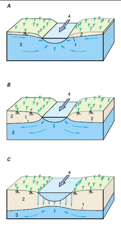
| Description | Relation between streams and underground water. A=Gaining stream, B= Losing stream, C= Losing stream that is disconectes from the water table. 1= Water table; 2= Unsaturated zone; 3= Saturated zone , 4=Flow direction |
| Source | USGS/USGov. |
| Author | |
| Permission (Reusing this file) |
Free for all use |
Licensing
[edit]
This work is in the public domain in the United States because it is a work prepared by an officer or employee of the United States Government as part of that person’s official duties under the terms of Title 17, Chapter 1, Section 105 of the US Code.
Note: This only applies to original works of the Federal Government and not to the work of any individual U.S. state, territory, commonwealth, county, municipality, or any other subdivision. This template also does not apply to postage stamp designs published by the United States Postal Service since 1978. (See § 313.6(C)(1) of Compendium of U.S. Copyright Office Practices). It also does not apply to certain US coins; see The US Mint Terms of Use.
|
 | |
| This file has been identified as being free of known restrictions under copyright law, including all related and neighboring rights. | ||
File history
Click on a date/time to view the file as it appeared at that time.
| Date/Time | Thumbnail | Dimensions | User | Comment | |
|---|---|---|---|---|---|
| current | 10:21, 27 September 2016 | | 1,063 × 2,087 (101 KB) | Cmdrjameson (talk | contribs) | Compressed with pngout. Reduced by 38kB (27% decrease). |
| 23:35, 14 September 2006 |  | 1,063 × 2,087 (140 KB) | Zimbres (talk | contribs) | {{Information |Description=Relation between streams and underground water. A=Gaining stream, B= Losing stream, C= Losing stream that is disconectes from the water table. 1= Water table; 2= Unsaturated zone; 3= Saturated zone , 4=Flow direction |Source=USG |
You cannot overwrite this file.
File usage
The following page uses this file:
Global file usage
The following other wikis use this file:
- Usage on ja.wikipedia.org
- Usage on kk.wikipedia.org
- Usage on pl.wikipedia.org