Category:Language-neutral geological diagrams
Jump to navigation
Jump to search
Subcategories
This category has only the following subcategory.
*
Media in category "Language-neutral geological diagrams"
The following 61 files are in this category, out of 61 total.
-
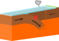
 Accretion-Subduction.PNG 751 × 388; 67 KB
-
 Arranque glaciar-lnf.svg 515 × 308; 100 KB
-
 Atoll forming-i18.png 1,667 × 2,423; 486 KB
-
 Atoll forming-volcano.png 263 × 194; 44 KB
-
 Batholite-Bloc-diagrame.png 500 × 300; 5 KB
-
 Continental shelf letters.png 456 × 180; 8 KB
-
 Continental-continental conservative plate boundary opposite directions.svg 2,637 × 1,484; 9 KB
-
 Continental-continental conservative plate boundary same direction.svg 2,637 × 1,484; 9 KB
-
 Continental-continental constructive plate boundary.svg 2,512 × 1,507; 15 KB
-
 Continental-continental destructive plate boundary.svg 2,512 × 1,537; 2 KB
-
 Crag and tail diagram.jpg 800 × 441; 19 KB
-
 Cutaway view east rift zone Kilauea-blank.png 620 × 230; 47 KB
-
 Cycle orogénique Schema1.svg 1,060 × 570; 50 KB
-
 Deichquerschnitt-multilang.svg 820 × 290; 39 KB
-
 Destructive plate margin.png 880 × 600; 65 KB
-
 Destructive plate margin.svg 880 × 600; 14 KB
-
 Earth cross section-i18.png 1,343 × 808; 84 KB
-
 Earthquake FW-HW Diagram.jpg 376 × 265; 63 KB
-
 Epicenter Hypocenter.png 1,425 × 767; 52 KB
-
 Fault types.svg 416 × 741; 154 KB
-
 GasDepositDiagram.svg 755 × 525; 105 KB
-
 Geysir 02 without inscription.png 534 × 479; 52 KB
-
 Glacial landscape LMB (no text).png 388 × 230; 43 KB
-
 Gravitational Acceleration Earth (dumb version).png 512 × 336; 22 KB
-
 Gravitational Acceleration Earth unlabeled.svg 512 × 337; 8 KB
-
 Igenous structures.jpg 315 × 180; 43 KB
-
 Intrusion types.svg 1,180 × 1,263; 72 KB
-
 Keresztirányú dűne.PNG 784 × 359; 12 KB
-
 Mid-ocean ridge topography.gif 240 × 180; 1.06 MB
-
 Oceanic-continental convergence Fig21oceancont (dumb version).png 450 × 265; 344 KB
-
 Oceanic-continental destructive plate boundary.svg 2,688 × 1,913; 7 KB
-
 Oceanic-oceanic constructive plate boundary.svg 2,512 × 1,507; 14 KB
-
 Oceanic-oceanic destructive plate boundary.svg 2,512 × 1,766; 11 KB
-
 Phacolith.jpg 786 × 563; 35 KB
-
 Plate boundary diagram assets pack.svg 2,512 × 1,596; 16 KB
-
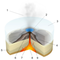
 Plinian Eruption-numbers.svg 1,100 × 1,100; 158 KB
-
 Principle of horizontal continuity.svg 1,100 × 450; 219 KB
-
 PSM V07 D402 Uinta mountains sectional image.jpg 2,512 × 1,131; 568 KB
-
 Rollover.png 2,339 × 1,654; 84 KB
-
 Sill.svg 300 × 200; 6 KB
-
 Stream underground water.png 1,063 × 2,087; 101 KB
-
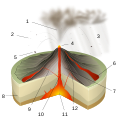 Strombolian Eruption-numbers.svg 1,100 × 1,100; 125 KB
-
 Strombolien (volcano).svg 610 × 935; 57 KB
-
 Structural Trap (Anticlinal).svg 640 × 413; 4 KB
-
 Structural Trap Fault.svg 640 × 413; 2 KB
-
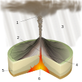
 Structure volcano unlabeled.svg 512 × 345; 213 KB
-
 Subduction x.png 350 × 350; 46 KB
-
 Subduction.svg 1,052 × 531; 76 KB
-
 SubductionDelamination.JPG 389 × 442; 17 KB
-
 Subduktion int.JPG 1,024 × 768; 145 KB
-
 Subglacial Eruption-blank.svg 1,100 × 1,100; 117 KB
-
 Subglacial Eruption-numbers batik.png 1,100 × 1,100; 308 KB
-
 Subglacial Eruption-numbers Inkscape.png 1,100 × 1,100; 364 KB
-
 Subglacial Eruption-numbers librsvg.png 1,100 × 1,100; 367 KB
-
 Subglacial Eruption-numbers rendersvg.png 1,100 × 1,100; 488 KB
-
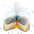
 Subglacial Eruption-numbers.svg 1,100 × 1,100; 141 KB
-
 Submarine Eruption-blank.svg 1,100 × 1,100; 163 KB
-
 Submarine Eruption-numbers.svg 1,100 × 1,100; 142 KB
-
 Surtseyan Eruption-numbers.svg 1,100 × 1,100; 188 KB
-
 Vulcanian Eruption-blank.svg 1,100 × 1,100; 144 KB
-
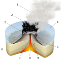
 Vulcanian Eruption-numbers.svg 1,100 × 1,100; 72 KB


.png)
.png)


.png)


.svg)
.svg)


