File:Subtropical Storm Andrea (2007).JPG

原始文件 (5,600 × 7,200像素,文件大小:6.76 MB,MIME类型:image/jpeg)
说明
说明
摘要
[编辑]| 描述 |
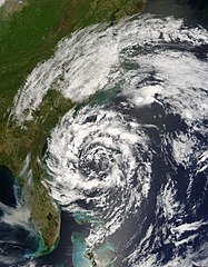
The circling clouds of an intense low-pressure system sat off the southeast coast of the United States on May 8, 2007, when the Moderate Resolution Imaging Spectroradiometer (MODIS) on NASA’s Terra satellite captured this image. By the following morning, the storm had developed enough to be classified as a subtropical storm, a storm that forms outside of the tropics, but has many of the characteristics—hurricane-force winds, driving rains, low pressure, and sometimes an eye—of a tropical storm. Although it arrived several weeks shy of the official start of the hurricane season (June 1), Subtropical Storm Andrea became the first named storm of the 2007 Atlantic hurricane season. The storm has the circular shape of a tropical cyclone in this image, but lacks the tight organization seen in more powerful storms. By May 9, the storm’s winds reached 75 kilometers per hour (45 miles per hour), and the storm was not predicted to get any stronger, said the National Hurricane Center. Though Subtropical Storm Andrea was expected to remain offshore, its strong winds and high waves pummeled coastal states, prompting a tropical storm watch. The winds fueled wild fires (marked with red boxes) in Georgia and Florida. The wind-driven flames generated thick plumes of smoke that concentrated in a gray-brown mass over Tampa Bay, Florida. Unfortunately for Georgia and Florida, which are experiencing moderate to severe drought, Subtropical Storm Andrea was not predicted to bring significant rain to the region right away, according to reports on the Washington Post Website. |
|||||
| 日期 | ||||||
| 来源 | http://eob.gsfc.nasa.gov/NaturalHazards/natural_hazards_v2.php3?img_id=14254 | |||||
| 作者 | NASA/GSFC, MODIS Rapid Response | |||||
| 授权 (二次使用本文件) |
|

.JPG&action=edit§ion=1)
文件历史
点击某个日期/时间查看对应时刻的文件。
| 日期/时间 | 缩略图 | 大小 | 用户 | 备注 | |
|---|---|---|---|---|---|
| 当前 | 2019年5月24日 (五) 16:26 | | 5,600 × 7,200(6.76 MB) | Nino Marakot(留言 | 贡献) | Reverted to version as of 17:54, 24 May 2007 (UTC) - Gallery version |
| 2018年12月6日 (四) 18:48 |  | 6,401 × 8,401(10.1 MB) | FleurDeOdile(留言 | 贡献) | 250m | |
| 2018年3月26日 (一) 00:41 |  | 1,700 × 2,100(804 KB) | CooperScience(留言 | 贡献) | Centering, contrast and coloring fixes (From EOSDIS Worldview) | |
| 2007年5月24日 (四) 17:54 |  | 5,600 × 7,200(6.76 MB) | Tom(留言 | 贡献) | higher res | |
| 2007年5月21日 (一) 01:09 |  | 538 × 558(86 KB) | Hurricanehink(留言 | 贡献) | {{Information |Description=The circling clouds of an intense low-pressure system sat off the southeast coast of the United States on May 8, 2007, when the Moderate Resolution Imaging Spectroradiometer (MODIS) on NASA’s Terra satellite captured this imag |
您不可以覆盖此文件。
文件用途
以下5个页面使用本文件:
- 2007 Atlantic hurricane season
- Commons:WikiProject Aviation/recent uploads/2018 December 6
- Commons:WikiProject Aviation/recent uploads/2018 March 26
- Commons:WikiProject Aviation/recent uploads/2019 May 24
- File:Released to Public Subtropical Storm Andrea, May 8, 2007 by NASA MODIS (NASA) (493761196).jpg(文件重定向)
_(493761196).jpg&redirect=no)
全域文件用途
以下其他wiki使用此文件:
- de.wikipedia.org上的用途
- en.wikipedia.org上的用途
- eu.wikipedia.org上的用途
- fr.wikipedia.org上的用途
- he.wikipedia.org上的用途
- pt.wikipedia.org上的用途
- simple.wikipedia.org上的用途
- sv.wikipedia.org上的用途
- zh.wikipedia.org上的用途
.JPG&oldid=476776294)