File:Sudanese Internal Conflict.svg
跳至導覽
跳至搜尋

此 SVG 檔案的 PNG 預覽的大小:684 × 600 像素。 其他解析度:274 × 240 像素 | 548 × 480 像素 | 876 × 768 像素 | 1,168 × 1,024 像素 | 2,336 × 2,048 像素 | 1,654 × 1,450 像素。
原始檔案 (SVG 檔案,表面大小:1,654 × 1,450 像素,檔案大小:382 KB)
說明
說明
添加單行說明來描述出檔案所代表的內容
摘要
[編輯]| 描述 |
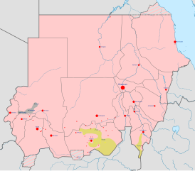
English: Map of the Sudanese conflict. The map image is based on Module:Sudanese Internal Conflict detailed map.
Under control of the Government and Allies
Under control of the Sudanese Awakening Revolutionary Council
Under control of the Sudan Revolutionary Front and allies |
||
| 日期 | |||
| 來源 | 自己的作品 | ||
| 作者 | Ali Zifan | ||
| 其他版本 |
|


.svg)


.svg)


.svg)


授權條款
[編輯]
我,本作品的著作權持有者,決定用以下授權條款發佈本作品:
此檔案採用共享創意 姓名標示-相同方式分享 4.0 國際授權條款。
- 您可以自由:
- 分享 – 複製、發佈和傳播本作品
- 重新修改 – 創作演繹作品
- 惟需遵照下列條件:
- 姓名標示 – 您必須指名出正確的製作者,和提供授權條款的連結,以及表示是否有對內容上做出變更。您可以用任何合理的方式來行動,但不得以任何方式表明授權條款是對您許可或是由您所使用。
- 相同方式分享 – 如果您利用本素材進行再混合、轉換或創作,您必須基於如同原先的相同或兼容的條款,來分布您的貢獻成品。
檔案歷史
點選日期/時間以檢視該時間的檔案版本。
| 日期/時間 | 縮圖 | 尺寸 | 用戶 | 備註 | |
|---|---|---|---|---|---|
| 目前 | 2016年6月6日 (一) 18:25 | | 1,654 × 1,450(382 KB) | Ermanarich(對話 | 貢獻) | Update, derived from the Template. |
| 2016年5月3日 (二) 20:20 |  | 1,654 × 1,450(380 KB) | Ermanarich(對話 | 貢獻) | Added towns and villages in South Kordofan under the control of SPLA-N and two contested settlements in Southern Darfur. | |
| 2016年2月21日 (日) 05:50 |  | 1,654 × 1,450(357 KB) | Oganesson007(對話 | 貢獻) | User created page with UploadWizard |
無法覆蓋此檔案。
檔案用途
下列22個頁面有用到此檔案:
- User:Magog the Ogre/Maps of conflicts/2016 June
- User:Oganesson007/Contributions
- User talk:967Bytes
- User talk:BlueHypercane761
- User talk:BurritoBazooka
- User talk:GamesDiscussion
- User talk:Kohelet
- User talk:Kumdano9
- User talk:Leo Kitbash28
- User talk:Libyanews247
- User talk:LightandDark2000
- User talk:Majed
- User talk:Michael2552
- User talk:Nykterinos
- User talk:Panam2014
- User talk:Pbfreespace3
- User talk:RokerHRO
- User talk:SomeGirl777
- User talk:Turnless
- User talk:Пэйнчик
- User talk:صفاء
- Category:Darfur conflict
全域檔案使用狀況
以下其他 wiki 使用了這個檔案:
- ar.wikipedia.org 的使用狀況
- ast.wikipedia.org 的使用狀況
- azb.wikipedia.org 的使用狀況
- be.wikipedia.org 的使用狀況
- ca.wikipedia.org 的使用狀況
- da.wikipedia.org 的使用狀況
- din.wikipedia.org 的使用狀況
- en.wikipedia.org 的使用狀況
- es.wikipedia.org 的使用狀況
- fa.wikipedia.org 的使用狀況
- fr.wikipedia.org 的使用狀況
- incubator.wikimedia.org 的使用狀況
- pnb.wikipedia.org 的使用狀況
- pt.wikipedia.org 的使用狀況
- ru.wikipedia.org 的使用狀況
- simple.wikipedia.org 的使用狀況
- th.wikipedia.org 的使用狀況
- tr.wikipedia.org 的使用狀況
- uk.wikipedia.org 的使用狀況
- ur.wikipedia.org 的使用狀況
- www.wikidata.org 的使用狀況
- zh.wikipedia.org 的使用狀況