File:Sumatra quake September 12, 2007.jpg
跳转到导航
跳转到搜索
本预览的尺寸:512 × 600像素。 其他分辨率:205 × 240像素 | 612 × 717像素。
原始文件 (612 × 717像素,文件大小:137 KB,MIME类型:image/jpeg)
说明
说明
添加一行文字以描述该文件所表现的内容
摘要
[编辑]
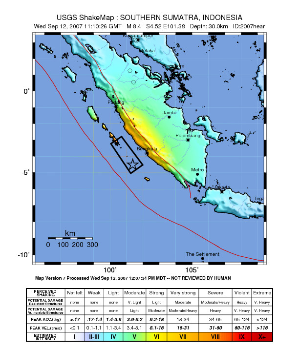
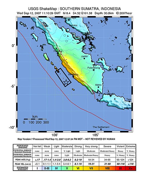
Image: Shake map of the magnitude 8.4 earthquake off the coast of Sumatra on September 12, 2007. Epicenter marked at star.
Source: https://earthquake.usgs.gov/eqcenter/shakemap/global/shake/2007hear/
许可协议
[编辑]
|
|
文件历史
点击某个日期/时间查看对应时刻的文件。
| 日期/时间 | 缩略图 | 大小 | 用户 | 备注 | |
|---|---|---|---|---|---|
| 当前 | 2007年9月13日 (四) 09:55 | | 612 × 717(137 KB) | TheDJ(留言 | 贡献) | |
| 2007年9月12日 (三) 15:23 |  | 612 × 717(136 KB) | Orlovic(留言 | 贡献) | == Summary == '''Image:''' Shake map of the magnitude 7.9 earthquake off the coast of Sumatra on September 12, 2007. Epicenter marked at star. '''Source:''' http://earthquake.usgs.gov/eqcenter/shakemap/global/shake/2007hear/ == Licensing = | |
| 2007年9月12日 (三) 13:46 |  | 612 × 718(126 KB) | TheDJ(留言 | 贡献) | == Summary == '''Image:''' Shake map of the magnitude 7.9 earthquake off the coast of Sumatra on September 12, 2007. Epicenter marked at star. '''Source:''' http://earthquake.usgs.gov/eqcenter/shakemap/global/shake/2007hear/ == Licensing = |
您不可以覆盖此文件。
文件用途
以下页面使用本文件:
全域文件用途
以下其他wiki使用此文件:
- en.wikinews.org上的用途
- fi.wikipedia.org上的用途
- id.wikipedia.org上的用途
- ja.wikipedia.org上的用途
- ms.wikipedia.org上的用途
- no.wikipedia.org上的用途
- zh.wikipedia.org上的用途