File:Super Typhoon Mangkhut (MODIS 2018-09-17).jpg

Original file (8,454 × 7,668 pixels, file size: 5.8 MB, MIME type: image/jpeg)
Captions
Captions
Summary[edit]
.jpg&action=edit§ion=1)
| Description |
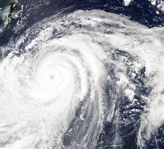
English: On September 14, 2018, Super Typhoon Mangkhut (Ompong) was taking direct aim at the Philippines and packing maximum sustained winds of about 167 mph (269 km/h)—a strong Category 5 storm on the Saffir-Simpson Hurricane Wind Scale. The Moderate Resolution Imaging Spectroradiometer (MODIS) aboard NASA’s Aqua satellite acquired a true-color image of the monster storm approaching the Philippines on that same day. Mangkhut sported a large cloud-filled eye and tight convective bands at the time the image was captured. It also appeared to be elongated, suggesting that wind shear was affecting the strength of the system.
In the early hours of September 15, Super Typhoon Mangkhut blew into Cagayan Province near the northern tip of Luzon, one of the most populated areas of the Philippine islands. Local reports described wind speeds of 205 kilometers (130 miles) per hour. The storm stretched nearly 900 kilometers (600 miles) across, with an eye 50 kilometers (30 miles) wide. It is the strongest tropical cyclone in any ocean basin so far this year. After walloping the Philippines, Typhoon Mangkhut took aim at southern China. The storm made landfall at about 5:00 p.m. local time on September 16 in Guangdong Province. Maximum sustained winds were about 107 mph (172 km/h), with much higher gusts, at landfall. Once on land, the winds slowed quickly although heavy rain and storm surge continued to create extremely hazardous conditions. In the afternoon of September 16, the Joint Typhoon Warning Center issued its last report, anticipating the imminent dissipation of Mangkhut well inland. Although only the first damage reports are coming in, it is clear Super Typhoon Mangkhut was a destructive, killer storm. When it crossed the U.S. territory of Guam on September 13, it knocked out 80 percent of the island’s electric power. The Philippines suffered more severe damage, with downed trees, damaged homes, and landslides being reported, along with at least 64 dead. In China, three deaths have been attributed to Mangkhut from the initial landfall, with more than 100 injured in and near Hong Kong. One death has been reported from Taiwan. |
||
| Date | Taken on 14 September 2018 | ||
| Source |
Super Typhoon Mangkhut (direct link)
|
||
| Author | MODIS Land Rapid Response Team, NASA GSFC |
| This media is a product of the Aqua mission Credit and attribution belongs to the mission team, if not already specified in the "author" row |
Licensing[edit]
.jpg&action=edit§ion=2)
| This file is in the public domain in the United States because it was solely created by NASA. NASA copyright policy states that "NASA material is not protected by copyright unless noted". (See Template:PD-USGov, NASA copyright policy page or JPL Image Use Policy.) | ||
 |
Warnings:
|
File history
Click on a date/time to view the file as it appeared at that time.
| Date/Time | Thumbnail | Dimensions | User | Comment | |
|---|---|---|---|---|---|
| current | 01:30, 17 February 2024 | | 8,454 × 7,668 (5.8 MB) | OptimusPrimeBot (talk | contribs) | #Spacemedia - Upload of http://modis.gsfc.nasa.gov/gallery/images/image09172018_250m.jpg via Commons:Spacemedia |
You cannot overwrite this file.
File usage on Commons
There are no pages that use this file.
.jpg&oldid=852528466)