File:Super Typhoon Yutu off Guam (MODIS 2018-10-27).jpg

Original file (6,878 × 6,456 pixels, file size: 3.82 MB, MIME type: image/jpeg)
Captions
Captions
Summary
[edit].jpg&action=edit§ion=1)
| Description |
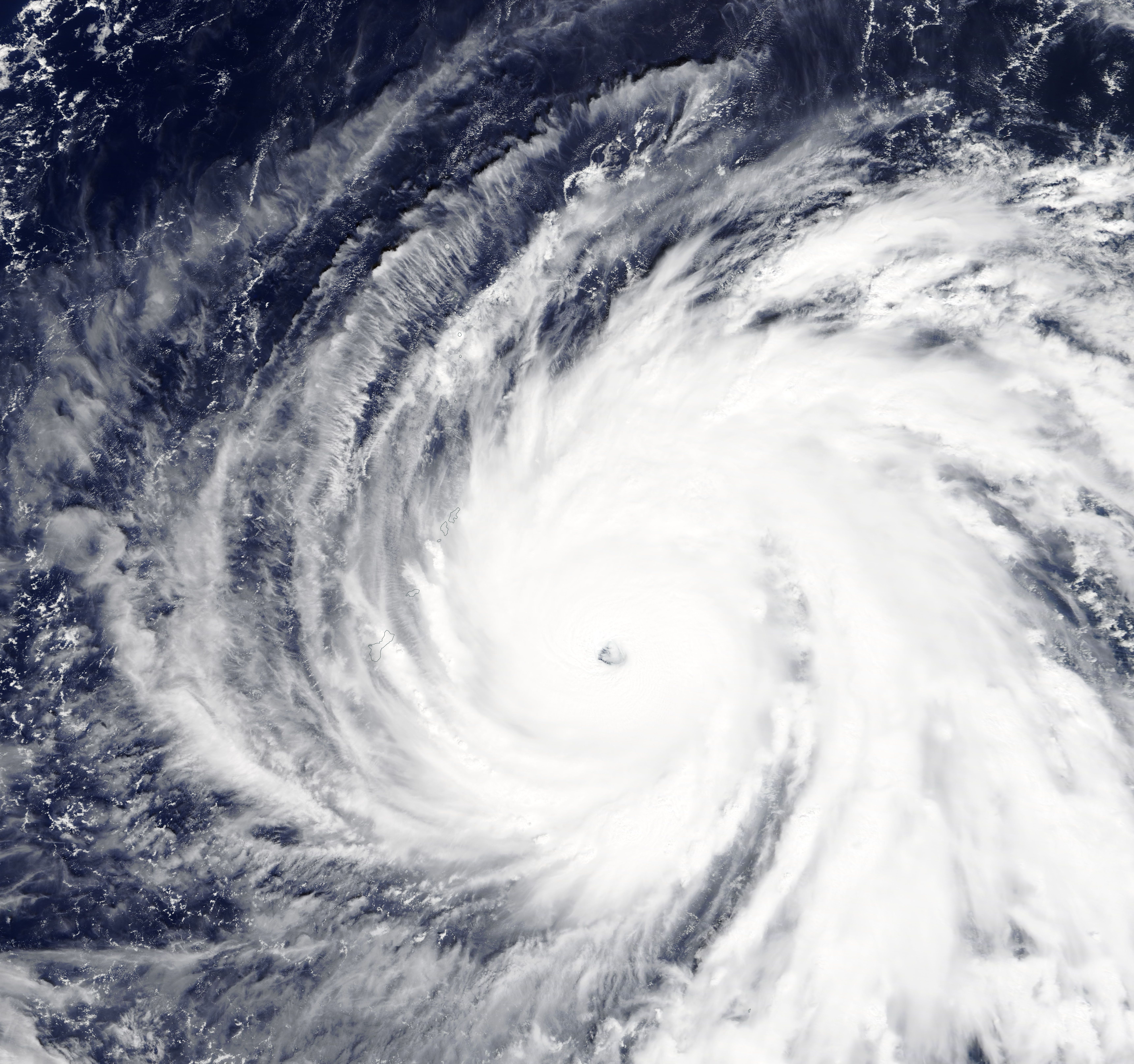
English: In just 30 hours from October 23-24, 2018, a tropical storm in the western Pacific Ocean exploded into a Category 5 super typhoon. Now that storm has made a direct hit on Tinian and Saipan in the Northern Mariana Islands, a territory of the United States.
Super Typhoon Yutu has tied Super Typhoon Mangkhut as the strongest storm on Earth this year and is likely the strongest to make a direct hit on the Mariana Islands since modern record-keeping began. Yutu is the 31st cyclonic storm of the Pacific typhoon season and the tenth Category 5 storm on Earth in 2018, the second most in any year. (In 1997, there were twelve Category 5 storms.) The true-color image above was acquired on October 24, 2018, by the Moderate Resolution Imaging Spectroradiometer (MODIS) on NASA’s Terra satellite. At 10 p.m. local time (12:00 Universal Time) on October 24, the Joint Typhoon Warning Center (JTWC) reported Yutu’s sustained wind speed was 180 mph (255 km/h), with gusts over 200 mph (322 km/h). Typhoon-force winds extended out to 85 mi (140 km) from the eye, with tropical storm-force winds stretching to 240 mi (390 km). Maximum significant wave height in the open ocean was estimated at 52 feet (16 meters), and forecasters were concerned about signficant storm surges on the Northern Mariana islands. Initial damage assessment on Saipan and Tinian islands brings reports of widespread and severe damage, with one person killed and more than 130 more injured. On October 26 at 5:00 p.m. EDT (2100 UTC) the JTWC reported that Super Typhoon Yutu was about 1,030 mi (1,658 km) east-northeast of Manilla, Philippines and was tracking west-northwestward at 16 mph (26 km/h). The storm maintains a large, sharply outlined eye and deepening convection and very cold cloud tops. The wind speed was estimated at about 160 mph (259 km/h). Super Typhoon Yutu is spinning in an area of favorable environment, with low easterly vertical wind shear and warm sea surface temperatures. Strengthening is expected over the next 24 hours, with peak wind speeds of about 166 mph (267 km/h) as it tracks towards northern Luzon in the Philippines, likely clipping the tip of the island around October 30. It is expected to weaken before this second landfall and then weaken more quickly over the South China Sea. |
||
| Date | Taken on 24 October 2018 | ||
| Source |
Super Typhoon Yutu off Guam (direct link)
|
||
| Author | MODIS Land Rapid Response Team, NASA GSFC |
| This media is a product of the Terra mission Credit and attribution belongs to the mission team, if not already specified in the "author" row |
Licensing
[edit].jpg&action=edit§ion=2)
| This file is in the public domain in the United States because it was solely created by NASA. NASA copyright policy states that "NASA material is not protected by copyright unless noted". (See Template:PD-USGov, NASA copyright policy page or JPL Image Use Policy.) | ||
 |
Warnings:
|
File history
Click on a date/time to view the file as it appeared at that time.
| Date/Time | Thumbnail | Dimensions | User | Comment | |
|---|---|---|---|---|---|
| current | 01:25, 17 February 2024 | | 6,878 × 6,456 (3.82 MB) | OptimusPrimeBot (talk | contribs) | #Spacemedia - Upload of http://modis.gsfc.nasa.gov/gallery/images/image10272018_250m.jpg via Commons:Spacemedia |
You cannot overwrite this file.
File usage on Commons
There are no pages that use this file.
.jpg&oldid=909382749)