File:Supraglacial lake.jpg
Jump to navigation
Jump to search
No higher resolution available.
Supraglacial_lake.jpg (515 × 348 pixels, file size: 59 KB, MIME type: image/jpeg)
Captions
Captions
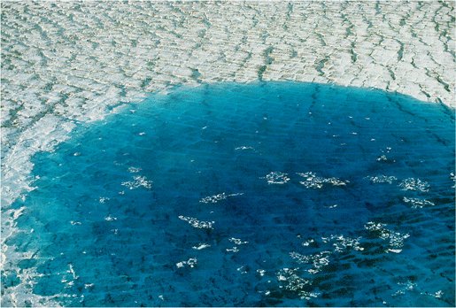
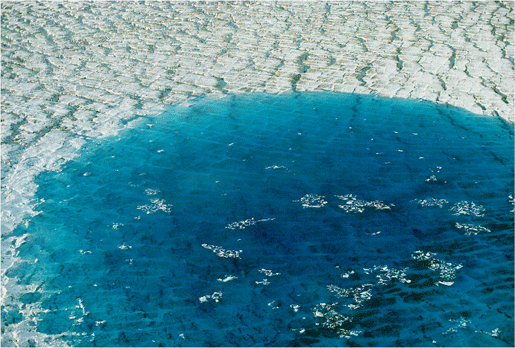
Supraglacial lake on the surface of Bering Glacier
| Description |
English: July 1995 oblique aerial photograph of most of a circular, blue water, supraglacial lake lake on the surface of Bering Glacier, the largest Alaskan glacier, located east of Cordova. The lake formed during the 1993-95 surge of the glacier. The lake has a diameter of ~ .5 miles. Bering Glacier flows through Wrangell-Saint Elias National Park. Chugach Mountains, Alaska. |
|||
| Date | ||||
| Source | United States Geological Survey | |||
| Author | United States Geological Survey | |||
| Permission (Reusing this file) |
|
File history
Click on a date/time to view the file as it appeared at that time.
| Date/Time | Thumbnail | Dimensions | User | Comment | |
|---|---|---|---|---|---|
| current | 06:19, 10 March 2008 | | 515 × 348 (59 KB) | The Cosmonaut (talk | contribs) | {{Information |Description= {{en|July 1995 oblique aerial photograph of most of a circular, blue water, supraglacial lake lake on the surface of Bering Glacier, the largest Alaskan glacier, located east of Cordova. |
You cannot overwrite this file.
File usage on Commons
There are no pages that use this file.
File usage on other wikis
The following other wikis use this file:
- Usage on ast.wikipedia.org
- Usage on de.wikipedia.org
- Usage on en.wikipedia.org
- Usage on es.wikipedia.org
- Usage on fa.wikipedia.org
- Usage on fr.wikipedia.org
- Usage on it.wikipedia.org
- Usage on pl.wikipedia.org
- Usage on uk.wikipedia.org