File:SurfaceConvexityMtRainier.jpg
Jump to navigation
Jump to search
No higher resolution available.
SurfaceConvexityMtRainier.jpg (800 × 500 pixels, file size: 72 KB, MIME type: image/jpeg)
Captions
Captions
Add a one-line explanation of what this file represents
| Description |
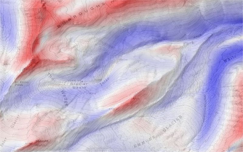
English: Surface curvature, convex-up in blue, concave-up in red derived from USGS 30m DEM of Mount Rainier, Washington. These curvature values calculated in w:LandSerf using a large kernel size to produce regional curvature measures. The results are blended in LandSerf with USGS topographic mapping to provide context. |
| Source | derived from USGS 30m DEM of Mount Rainier, Washington. These curvature values calculated in w:LandSerf using a large kernel size to produce regional curvature measures. The results are blended in LandSerf with USGS topographic mapping to provide context. |
| Author |
This image is in the public domain in the United States because it only contains materials that originally came from the United States Geological Survey, an agency of the United States Department of the Interior. For more information, see the official USGS copyright policy.
|
File history
Click on a date/time to view the file as it appeared at that time.
| Date/Time | Thumbnail | Dimensions | User | Comment | |
|---|---|---|---|---|---|
| current | 11:43, 14 May 2005 | | 800 × 500 (72 KB) | Jwo (talk | contribs) | Surface curvature, convex-up in blue, concave-up in red derived from USGS 30m DEM of Mount Rainier, Washington. These curvature values calculated in LandSerf using a large kernel size to produce regional curvature measures. The results are blended in |
You cannot overwrite this file.
File usage on Commons
There are no pages that use this file.
File usage on other wikis
The following other wikis use this file:
- Usage on en.wikipedia.org