File:Surrey - By H. Moll Geographer - btv1b53056455n.jpg
Original file (4,080 × 2,952 pixels, file size: 2.07 MB, MIME type: image/jpeg)
Captions
Captions
Summary
[edit]| English: Surrey by H. Moll Geographer
( |
|||||||||||||||||||||||||||
|---|---|---|---|---|---|---|---|---|---|---|---|---|---|---|---|---|---|---|---|---|---|---|---|---|---|---|---|
| Author |
|
||||||||||||||||||||||||||
| Title |
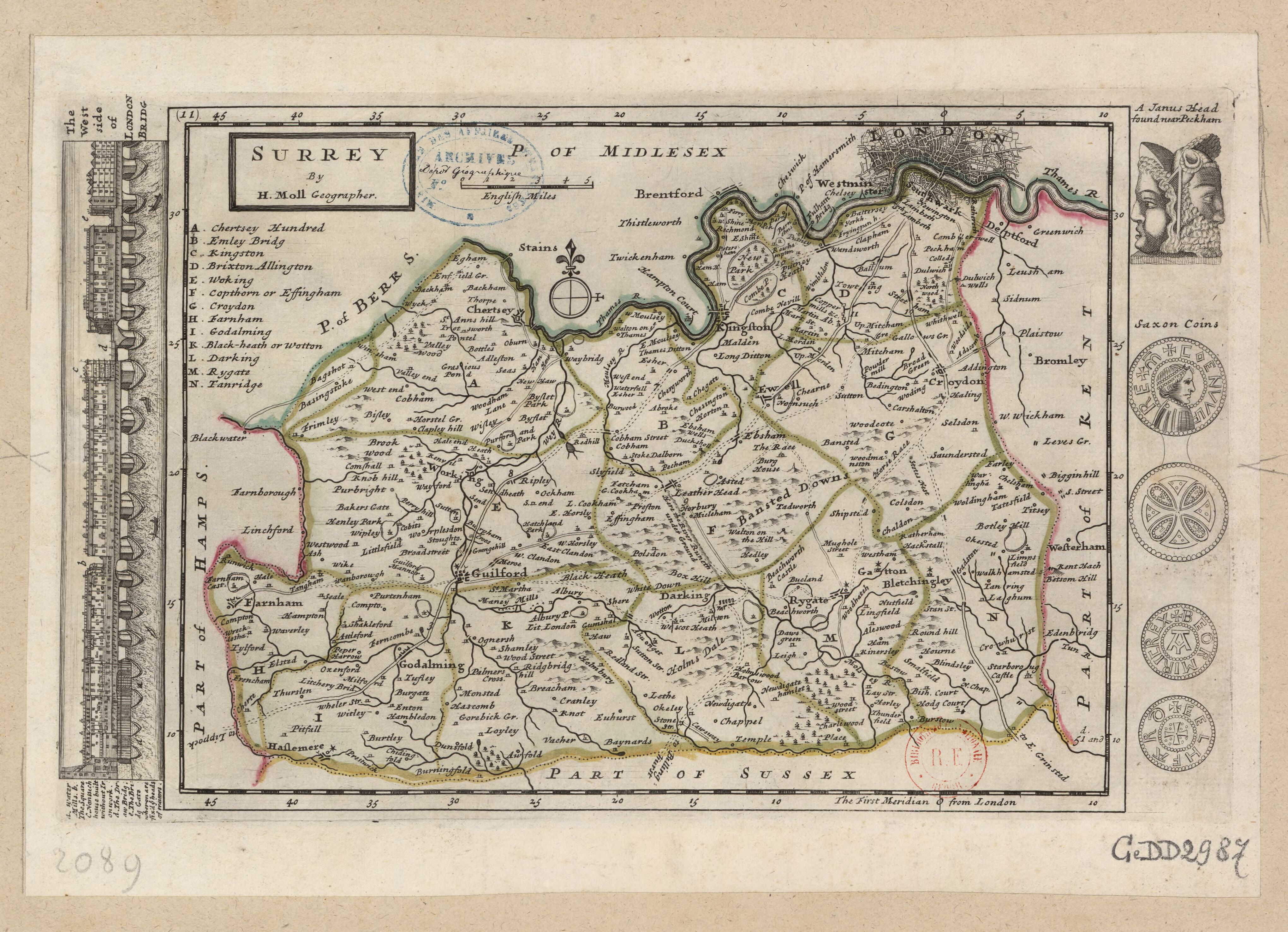
English: Surrey by H. Moll Geographer |
||||||||||||||||||||||||||
| Description |
English: Moll's map of Surrey, sold separately and as Map 11 in his Set of Fifty New and Correct Maps of England and Wales... Illustrations in the margins of London Bridge from the West, a Janus head found near Peckham, and two Saxon coins of Coenwulf of Mercia (apparently conflated with Cynewulf of Wessex) and Beorhtric of Wessex.
Français : Sujet : Antiquités romaines
Monnaies Divisions politiques et administratives Surrey, Comté du -- Divisions politiques et administratives Londres -- Ponts Échelle(s) : 5 English Miles [= 3,5 cm] Référence bibliographique : 173 Appartient à l’ensemble documentaire : AnvilEur Appartient à l’ensemble documentaire : MAEDI008 Appartient à l’ensemble documentaire : MAEDIGen0 Couverture : Royaume-Uni – Angleterre – Surrey Langue : anglais |
||||||||||||||||||||||||||
| Date | 1724 | ||||||||||||||||||||||||||
| Dimensions | height: 33 cm (12.9 in); width: 23.5 cm (9.2 in) | ||||||||||||||||||||||||||
| Collection |
|
||||||||||||||||||||||||||
| References |
Français : Notice de recueil : http://catalogue.bnf.fr/ark:/12148/cb40577015h
Appartient à : Collection d'Anville ; 02089 Notice du catalogue : http://catalogue.bnf.fr/ark:/12148/cb41246909t |
||||||||||||||||||||||||||
| Source/Photographer |
Français : Bibliothèque nationale de France, département Cartes et plans, GE DD-2987 (2089)
Bibliothèque nationale de France |
||||||||||||||||||||||||||
| Permission (Reusing this file) |
|
||||||||||||||||||||||||||
| Other versions |
|
||||||||||||||||||||||||||


| Annotations | This image is annotated: View the annotations at Commons |
File history
Click on a date/time to view the file as it appeared at that time.
| Date/Time | Thumbnail | Dimensions | User | Comment | |
|---|---|---|---|---|---|
| current | 02:49, 19 August 2022 | | 4,080 × 2,952 (2.07 MB) | Gzen92Bot (talk | contribs) | Gallica btv1b53056455n |
You cannot overwrite this file.
File usage on Commons
The following 12 pages use this file:
- File:Janus Head Found near Peckham.jpg
- File:London 1724.jpg
- File:Midlesex - By H. Moll Geographer - btv1b530568320.jpg
- File:Saxon Coin of Beormiric.jpg
- File:Saxon Coin of Beormiric (obverse).jpg
- File:Saxon Coin of Beormiric (reverse).jpg
- File:Saxon Coin of Coenuulf.jpg
- File:Saxon Coin of Coenuulf (obverse).jpg
- File:Saxon Coin of Coenuulf (reverse).jpg
- File:Saxon Coins.jpg
- File:Surrey - By H. Moll Geographer - btv1b53056455n.jpg
- File:West side of London Bridg.jpg
.jpg)
.jpg)
.jpg)
.jpg)