File:Survey of Palestine, Palestine (FL62997536 4712852).jpg
Jump to navigation
Jump to search

Size of this preview: 454 × 599 pixels. Other resolutions: 182 × 240 pixels | 364 × 480 pixels | 582 × 768 pixels | 776 × 1,024 pixels | 1,552 × 2,048 pixels | 7,380 × 9,740 pixels.
Original file (7,380 × 9,740 pixels, file size: 76.49 MB, MIME type: image/jpeg)
Captions
Captions
Add a one-line explanation of what this file represents
Summary
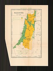
[edit]| Survey of Palestine: Palestine
( |
||||||||||||||||||||||||
|---|---|---|---|---|---|---|---|---|---|---|---|---|---|---|---|---|---|---|---|---|---|---|---|---|
| Artist |
|
|||||||||||||||||||||||
| Title |
Palestine |
|||||||||||||||||||||||
| Publisher |
Survey of Palestine |
|||||||||||||||||||||||
| Description |
Palestine.. |
|||||||||||||||||||||||
| Language | English | |||||||||||||||||||||||
| Publication date | 1937 | |||||||||||||||||||||||
| Medium | 1 map : color ; | |||||||||||||||||||||||
| Dimensions | 28 × 18 cm (11 × 7 in) | |||||||||||||||||||||||
| Collection |
|
|||||||||||||||||||||||
| Current location |
|
|||||||||||||||||||||||
| Place of publication | Jaffa | |||||||||||||||||||||||
| search Merhav catalog | Jaffa | |||||||||||||||||||||||
| Notes | No.6. | |||||||||||||||||||||||
| scale | 1:1,000,000 cm | |||||||||||||||||||||||
| IE PID | IE62997534 | |||||||||||||||||||||||
| Rosetta filename | FL62997536 | |||||||||||||||||||||||
| NNL item ID (P3959) | 990047128520205171 | |||||||||||||||||||||||
| search Merhav catalog | English, Survey of Palestine | |||||||||||||||||||||||
| search Merhav catalog | Cultivation zonesTillageEretz IsraelSurvey of Palestine | |||||||||||||||||||||||
| Source/Photographer |
|
|||||||||||||||||||||||
| Other versions | ||||||||||||||||||||||||
| Jpg / Tif version |
|
|||||||||||||||||||||||

.jpg)

.jpg&action=edit§ion=1)
Licensing
[edit].jpg&action=edit§ion=2)
This work created by the United Kingdom Government is in the public domain.
This is because it is one of the following:
HMSO has declared that the expiry of Crown Copyrights applies worldwide (ref: HMSO Email Reply)
|
 |
File history
Click on a date/time to view the file as it appeared at that time.
| Date/Time | Thumbnail | Dimensions | User | Comment | |
|---|---|---|---|---|---|
| current | 07:32, 11 August 2023 | | 7,380 × 9,740 (76.49 MB) | Geagea (talk | contribs) | pattypan 22.03 |
You cannot overwrite this file.
File usage on Commons
The following page uses this file:
.jpg&oldid=792147513)