File:Survey of Palestine, Transjordan 03-Sheet-2--Arabic (FL155196437 2367042).jpg
Jump to navigation
Jump to search

Size of this preview: 481 × 600 pixels. Other resolutions: 192 × 240 pixels | 385 × 480 pixels | 616 × 768 pixels | 821 × 1,024 pixels | 1,643 × 2,048 pixels | 11,705 × 14,590 pixels.
Original file (11,705 × 14,590 pixels, file size: 162.95 MB, MIME type: image/jpeg)
Captions
Captions
Add a one-line explanation of what this file represents
Summary
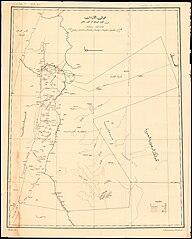
[edit]| Survey of Palestine: Transjordan
( |
||||||||||||||||||||||||
|---|---|---|---|---|---|---|---|---|---|---|---|---|---|---|---|---|---|---|---|---|---|---|---|---|
| Artist |
|
|||||||||||||||||||||||
| Title |
Transjordan |
|||||||||||||||||||||||
| Publisher |
Survey of Palestine |
|||||||||||||||||||||||
| Description |
Transjordan. Drawn and printed at the Survey of Palestine. |
|||||||||||||||||||||||
| Language | Arabic, English | |||||||||||||||||||||||
| Publication date | 1935 | |||||||||||||||||||||||
| Collection |
|
|||||||||||||||||||||||
| Current location |
|
|||||||||||||||||||||||
| Place of publication | Jaffa | |||||||||||||||||||||||
| search Merhav catalog | Jaffa | |||||||||||||||||||||||
| Notes | Sheet 1: From earliest times to the Herodian period. Sheet 2: From the Roman period till the present day [a version in English and a version in Arabic]. | |||||||||||||||||||||||
| scale | 1:1,000,000 cm | |||||||||||||||||||||||
| IE PID | IE155196428 | |||||||||||||||||||||||
| Rosetta filename | FL155196437 | |||||||||||||||||||||||
| NNL item ID (P3959) | 990023670420205171 | |||||||||||||||||||||||
| search Merhav catalog | Arabic, English, Survey of Palestine | |||||||||||||||||||||||
| search Merhav catalog | Survey of Palestine | |||||||||||||||||||||||
| Source/Photographer |
|
|||||||||||||||||||||||
| Other versions | ||||||||||||||||||||||||
| Jpg / Tif version |
|
|||||||||||||||||||||||

.jpg)

.jpg&action=edit§ion=1)
Licensing
[edit].jpg&action=edit§ion=2)
This work created by the United Kingdom Government is in the public domain.
This is because it is one of the following:
HMSO has declared that the expiry of Crown Copyrights applies worldwide (ref: HMSO Email Reply)
|
 |
File history
Click on a date/time to view the file as it appeared at that time.
| Date/Time | Thumbnail | Dimensions | User | Comment | |
|---|---|---|---|---|---|
| current | 03:28, 27 July 2023 | | 11,705 × 14,590 (162.95 MB) | Geagea (talk | contribs) | pattypan 22.03 |
You cannot overwrite this file.
File usage on Commons
The following page uses this file:
.jpg&oldid=787169904)