File:Survey of the harbour of port Mahon in Minorca - by Lieutenant William Henry Smith - btv1b53163312t.jpg
Jump to navigation
Jump to search

Size of this preview: 800 × 590 pixels. Other resolutions: 320 × 236 pixels | 640 × 472 pixels | 1,024 × 755 pixels | 1,280 × 944 pixels | 2,560 × 1,887 pixels | 9,136 × 6,736 pixels.
Original file (9,136 × 6,736 pixels, file size: 7.1 MB, MIME type: image/jpeg)
Captions
Captions
Add a one-line explanation of what this file represents
Summary
[edit]| Warning | The original file is very high-resolution. It might not load properly or could cause your browser to freeze when opened at full size. |
|---|
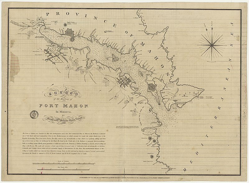
| Survey of the harbour of port Mahon in Minorca / by Lieutenant William Henry Smith
( |
|||||||||||||||||||||||||||
|---|---|---|---|---|---|---|---|---|---|---|---|---|---|---|---|---|---|---|---|---|---|---|---|---|---|---|---|
| Author |
Smith, William Henry (18..-18..). Cartographe |
||||||||||||||||||||||||||
| Title |
Survey of the harbour of port Mahon in Minorca / by Lieutenant William Henry Smith |
||||||||||||||||||||||||||
| Description |
Français : Sujet : Mahón
Échelle(s) : [1:11594] Couverture : Espagne – Îles Baléares Mer Méditerranée – Bassin Ouest – Mer des Baléares E 4°16' / N 39°53' Langue : anglais Éditeur : Jas. Whittle and Richd. Holmes Laurie (Londres) |
||||||||||||||||||||||||||
| Date | 1813 | ||||||||||||||||||||||||||
| Dimensions | height: 77 cm (30.3 in); width: 56 cm (22 in) | ||||||||||||||||||||||||||
| Collection |
|
||||||||||||||||||||||||||
| References |
Français : Notice de recueil : http://catalogue.bnf.fr/ark:/12148/cb45393091d
Appartient à : [Division 17 du portefeuille 70 du Service hydrographique de la marine consacrée à la ville et au port de Mahon] ; 25 D Notice du catalogue : http://catalogue.bnf.fr/ark:/12148/cb45393708z |
||||||||||||||||||||||||||
| Source/Photographer |
Français : Bibliothèque nationale de France, département Cartes et plans, GE SH 19 PF 70 DIV 17 P 25 D
Bibliothèque nationale de France |
||||||||||||||||||||||||||
| Permission (Reusing this file) |
|
||||||||||||||||||||||||||

File history
Click on a date/time to view the file as it appeared at that time.
| Date/Time | Thumbnail | Dimensions | User | Comment | |
|---|---|---|---|---|---|
| current | 19:18, 16 July 2022 | | 9,136 × 6,736 (7.1 MB) | Gzen92Bot (talk | contribs) | Gallica btv1b53163312t |
You cannot overwrite this file.
File usage on Commons
The following page uses this file: