File:Swirls of Ice in the Labrador Sea (MODIS 2016-08-12).jpg

Original file (4,000 × 4,000 pixels, file size: 4.26 MB, MIME type: image/jpeg)
Captions
Captions
Summary
[edit].jpg&action=edit§ion=1)
| Description |
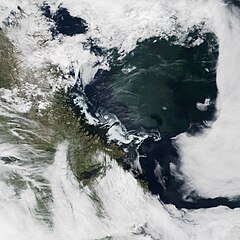
English: The Moderate Resolution Imaging Spectroradiometer (MODIS) on NASA’s Terra satellite acquired this true-color image of an ice eddy off the coast of Labrador, Canada, on July 2, 2016.
When pilot Jeff Davis saw the cyclone-like formation from 36,000 feet, he thought he had spotted a storm. “I’ve never seen anything like this,” he said in an interview with Mashable. “At first sight I thought it was a hurricane-type low-pressure system, but quickly realized what I was seeing was not clouds, but surface ice... This was a rare sight.” Davis, who has been piloting trans-Atlantic flights for 16 years, said it was his first time spotting such a formation. That’s because clear skies and air and water temperatures must align to make a formation like this visible from cruising altitude, said Walter Meier, a cryospheric researcher at NASA. First, the viewer needs daylight, a cloudless sky, and lucky timing. “If the eddy is too small or compact, you won’t see it. If the ice is too thick, or if it’s melted, you’re not gonna see it either,” said Meier. “There’s not a lot of time between those two extremes.” When the ice melts, it breaks into chunks, like crushed ice in a cocktail. Then, ocean currents stir those chunks into the cyclone-like vortex. This happens both in spring (as ice thaws) and in fall (during melt). Even then, however, such a vortex won’t form unless it has certain temperature conditions: warm enough for the ice to fragment, but cool enough for it to remain frozen. While the opportunity to view an eddy like this is rare because of frequent cloudiness over Arctic seas, Meier notes that ice eddies are pretty common. The formations can be large (several hundred kilometers across), or small (just several hundred meters). The chunks of ice in such eddies can be several meters across, posing a hazard for ships. |
||
| Date | Taken on 2 July 2016 | ||
| Source |
Swirls of Ice in the Labrador Sea (direct link)
|
||
| Author | Jeff Schmaltz, MODIS Land Rapid Response Team, NASA GSFC |
| This media is a product of the Terra mission Credit and attribution belongs to the mission team, if not already specified in the "author" row |
Licensing
[edit].jpg&action=edit§ion=2)
| This file is in the public domain in the United States because it was solely created by NASA. NASA copyright policy states that "NASA material is not protected by copyright unless noted". (See Template:PD-USGov, NASA copyright policy page or JPL Image Use Policy.) | ||
 |
Warnings:
|
File history
Click on a date/time to view the file as it appeared at that time.
| Date/Time | Thumbnail | Dimensions | User | Comment | |
|---|---|---|---|---|---|
| current | 19:24, 15 February 2024 | | 4,000 × 4,000 (4.26 MB) | OptimusPrimeBot (talk | contribs) | #Spacemedia - Upload of http://modis.gsfc.nasa.gov/gallery/images/image08122016_250m.jpg via Commons:Spacemedia |
You cannot overwrite this file.
File usage on Commons
There are no pages that use this file.
.jpg&oldid=852068342)