File:Tagebau Garzweiler (846).jpg
Jump to navigation
Jump to search
Size of this preview: 800 × 533 pixels. Other resolutions: 320 × 213 pixels | 640 × 427 pixels | 1,024 × 683 pixels | 1,280 × 853 pixels | 2,560 × 1,707 pixels | 3,888 × 2,592 pixels.
Original file (3,888 × 2,592 pixels, file size: 3.82 MB, MIME type: image/jpeg)
Captions
Captions
Add a one-line explanation of what this file represents
Summary
[edit].jpg&action=edit§ion=1)
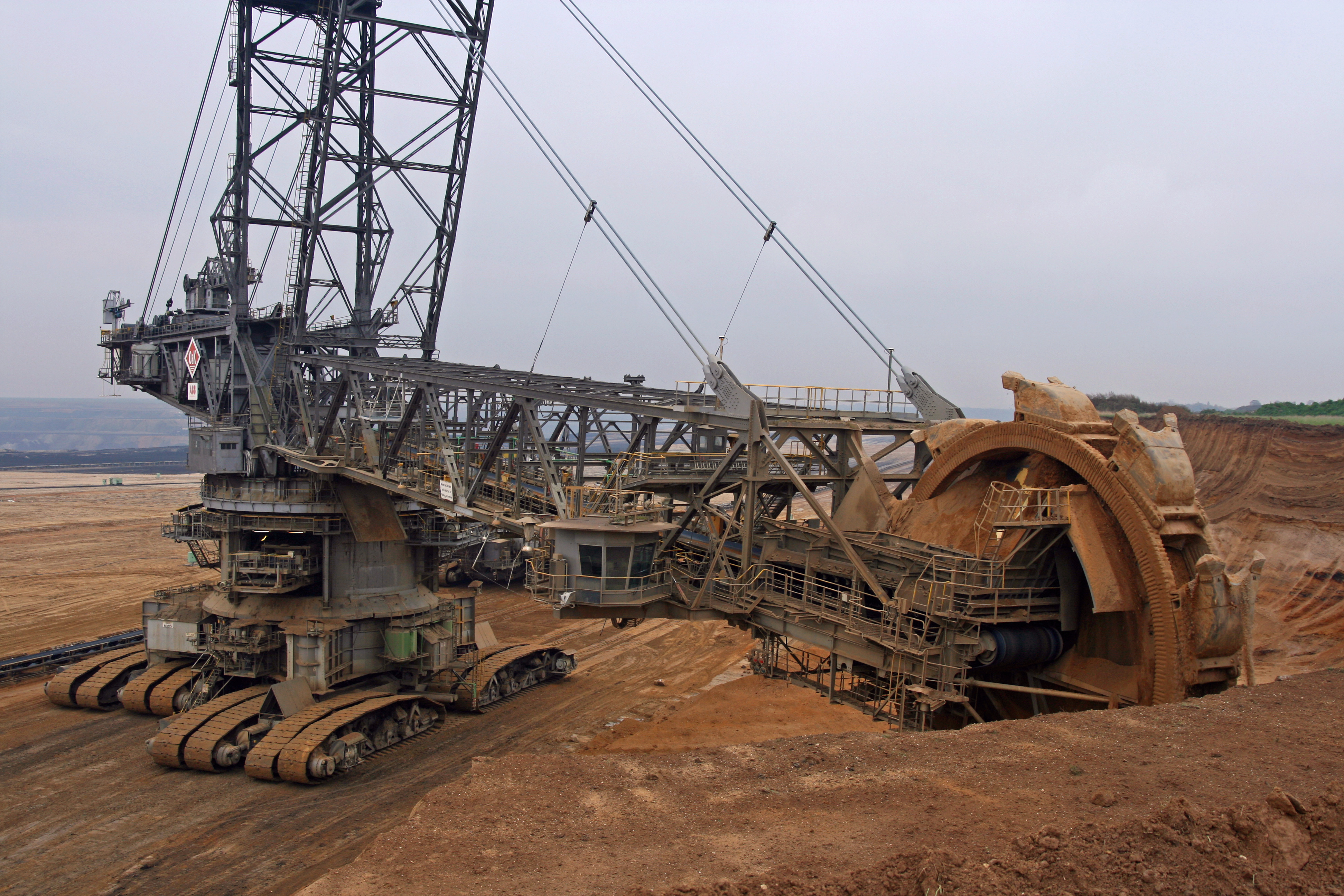
| Tagebau Garzweiler | |
|---|---|
| Photographer | |
| Title |
Tagebau Garzweiler |
| Description |
The brown-coal mine to open sky of Garzweiler (Braunkohletagebau Garzweiler) is a site of extraction of Lignite, named according to the village of Jüchen-Garzweiler in the commune of Jüchen (Rhein-Kreis Neuss), located at ten kilometers in the south of Mönchengladbach, in Rhineland-of-North-Westphalia (Germany), and exploited by the company RWE Power AG. The village of Garzweiler was demolished, and the place then entirely cleared the extraction of the lignite parallel to, and became today - in particular in German the ecologists mediums - synonym of lignite exploitation with open sky. The lignite extraction undertaken by subsidiary company RWE Power AG of firm RWE AG (in the past Rheinbraun - lignite saying in German Braunkohle) took place up to now only in the first of the two sections envisaged, Garzweiler I and II. Garzweiler I includes/understands the extent located at the east of the highway A 44, while the exploitation site Garzweiler II corresponds to a sector in the west of has 44; this last, large of 48 km2, is definitely vaster. March 31st, 1995, the government of the Land of Rhineland-of-North-Westphalia gave its downstream to the implementation of the Braunkohleplan Garzweiler II . Also the general purpose excavators could, on June 18th, 2006, to start this new zone. Are concerned now, for the first time, and with 40 km2 height, of the portions of territory of the town of Erkelenz (Kreis Heinsberg). A third approximately of the surface of this city will be put at contribution. 6,5 km2 are located on the territory of the commune of Jüchen and approximately 1,5 km2 on the territory of the town of Mönchengladbach, which will be thus for the first time it so implied in this mining project. The period of extraction envisaged extends from 2006 at 2045. The breaking-down of the coal is carried out with open sky (exploitation into discovered or by discovered) and the activity are connected then with a project of earthwork which moves gradually. Garzweiler II has a brown-coal bed of 1,3 billion tons. The t/c report/ratio - which expresses the relationship between the quantity of cleared dead ground (i.e. the quantity of ground that it is necessary to release initially before reaching the coal seam) and the quantity of coal extracted -, is here of 5/1, which is favorable. The Garzweiler project requires the evacuation and the removal of whole localities. With regard to the project Garzweiler II, twelve villages and 7600 inhabitants will be touched. |
| Depicted place | Depicted place: Garzweiler surface mine |
| Date | 31 October 2008 |
| Source | Flickr.com |
Licensing
[edit].jpg&action=edit§ion=2)
| This image, originally posted to Flickr, was reviewed on 28 March 2024 by the administrator or reviewer Leoboudv, who confirmed that it was available on Flickr under the stated license on that date. |
This file is licensed under the Creative Commons Attribution 2.0 Generic license.
- You are free:
- to share – to copy, distribute and transmit the work
- to remix – to adapt the work
- Under the following conditions:
- attribution – You must give appropriate credit, provide a link to the license, and indicate if changes were made. You may do so in any reasonable manner, but not in any way that suggests the licensor endorses you or your use.
File history
Click on a date/time to view the file as it appeared at that time.
| Date/Time | Thumbnail | Dimensions | User | Comment | |
|---|---|---|---|---|---|
| current | 07:34, 27 June 2023 | | 3,888 × 2,592 (3.82 MB) | Jason.nlw (talk | contribs) | pattypan 22.03 |
You cannot overwrite this file.
File usage on Commons
The following page uses this file:
.jpg)
.jpg&oldid=864015713)